Estimated Value: $382,000 - $395,000
3
Beds
2
Baths
2,242
Sq Ft
$173/Sq Ft
Est. Value
About This Home
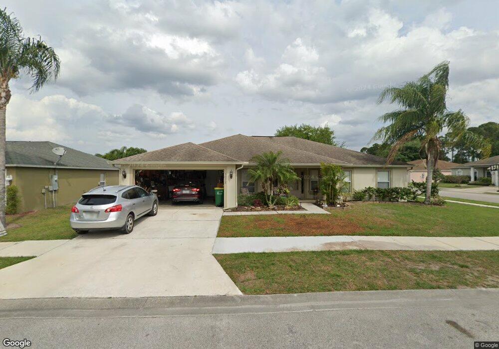
This home is located at 5672 Yaupon Holly Dr, Cocoa, FL 32927 and is currently estimated at $387,260, approximately $172 per square foot. 5672 Yaupon Holly Dr is a home located in Brevard County with nearby schools including Atlantis Elementary School, Space Coast Junior/Senior High School, and Sculptor Charter School.
Ownership History
Date
Name
Owned For
Owner Type
Purchase Details
Closed on
Apr 16, 2024
Sold by
Pommier Michael
Bought by
Pommier Nicole and Pommier Michael
Current Estimated Value
Purchase Details
Closed on
Jul 17, 2006
Sold by
Holiday Builders Inc
Bought by
Pommier Michael A
Home Financials for this Owner
Home Financials are based on the most recent Mortgage that was taken out on this home.
Original Mortgage
$193,119
Interest Rate
7.5%
Create a Home Valuation Report for This Property
The Home Valuation Report is an in-depth analysis detailing your home's value as well as a comparison with similar homes in the area
Home Values in the Area
Average Home Value in this Area
Purchase History
| Date | Buyer | Sale Price | Title Company |
|---|---|---|---|
| Pommier Nicole | $100 | None Listed On Document | |
| Pommier Michael A | $241,400 | Hbi Title Company |
Source: Public Records
Mortgage History
| Date | Status | Borrower | Loan Amount |
|---|---|---|---|
| Previous Owner | Pommier Michael A | $193,119 |
Source: Public Records
Tax History Compared to Growth
Tax History
| Year | Tax Paid | Tax Assessment Tax Assessment Total Assessment is a certain percentage of the fair market value that is determined by local assessors to be the total taxable value of land and additions on the property. | Land | Improvement |
|---|---|---|---|---|
| 2025 | $2,037 | $145,320 | -- | -- |
| 2024 | $1,994 | $141,230 | -- | -- |
| 2023 | $1,994 | $137,120 | $0 | $0 |
| 2022 | $1,867 | $133,130 | $0 | $0 |
| 2021 | $1,901 | $129,260 | $0 | $0 |
| 2020 | $1,818 | $127,480 | $0 | $0 |
| 2019 | $1,759 | $124,620 | $0 | $0 |
| 2018 | $1,753 | $122,300 | $0 | $0 |
| 2017 | $1,750 | $119,790 | $0 | $0 |
| 2016 | $1,762 | $117,330 | $25,000 | $92,330 |
| 2015 | $1,793 | $116,520 | $25,000 | $91,520 |
| 2014 | $1,799 | $115,600 | $22,000 | $93,600 |
Source: Public Records
Map
Nearby Homes
- 5730 Friendly St
- 7358 Crepe Myrtle Ct
- 7368 Crepe Myrtle Ct
- 5740 Friendly St
- 7469 Hackberry Rd
- TBD Freeport Rd
- 7230 Venus Ave
- 7635 Fringe Place
- 7545 Fringe Place
- 7065 Hundred Acre Dr
- 5170 Everett St
- 7310 Joshua Place
- 1389 Moscato Dr
- 5165 Patricia St
- 7302 Bumelia Dr
- 7275 Durban Ave
- 5155 Mayflower St
- 5200 Frisco St
- 5130 Carter St
- 7155 Export Ave
- 5682 Yaupon Holly Dr
- 5632 Yaupon Holly Dr
- 5643 Yaupon Holly Dr
- 5653 Yaupon Holly Dr
- 5673 Yaupon Holly Dr
- 5683 Yaupon Holly Dr
- 5461 Cinnamon Fern Blvd
- 5633 Yaupon Holly Dr
- 5592 Yaupon Holly Dr
- 5663 Yaupon Holly Dr
- 5582 Yaupon Holly Dr
- 5451 Cinnamon Fern Blvd
- 5693 Yaupon Holly Dr
- 5623 Yaupon Holly Dr
- 5441 Cinnamon Fern Blvd
- 5481 Cinnamon Fern Blvd
- 5630 Ranch Rd
- 5613 Yaupon Holly Dr
- 5593 Yaupon Holly Dr
- 5460 Cinnamon Fern Blvd