Estimated Value: $917,032 - $1,296,000
4
Beds
2
Baths
1,583
Sq Ft
$706/Sq Ft
Est. Value
About This Home
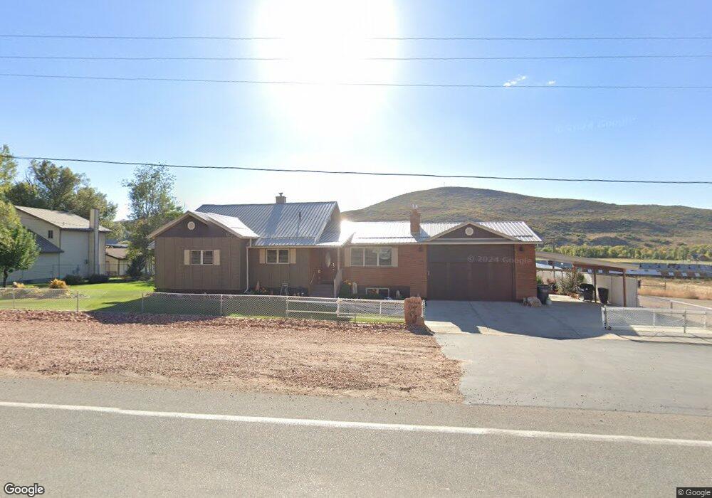
This home is located at 5685 Utah 32, Peoa, UT 84061 and is currently estimated at $1,117,508, approximately $705 per square foot. 5685 Utah 32 is a home located in Summit County with nearby schools including South Summit Elementary School and South Summit High School.
Ownership History
Date
Name
Owned For
Owner Type
Purchase Details
Closed on
Oct 25, 2019
Sold by
Marchant Jack W and Marchant Dixie R
Bought by
Marchant Jack W and Marchant Dixie R
Current Estimated Value
Purchase Details
Closed on
Mar 27, 2017
Sold by
Norval & Dorothy Estates Llc
Bought by
Marchant Jack W and Marchant Dixie R
Purchase Details
Closed on
Aug 29, 2011
Sold by
Norval & Dorothy Estates Llc
Bought by
Marchant Jack W and Marchant Dixie E
Create a Home Valuation Report for This Property
The Home Valuation Report is an in-depth analysis detailing your home's value as well as a comparison with similar homes in the area
Home Values in the Area
Average Home Value in this Area
Purchase History
| Date | Buyer | Sale Price | Title Company |
|---|---|---|---|
| Marchant Jack W | -- | None Available | |
| Marchant Jack W | -- | None Available | |
| Marchant Jack W | -- | Fonders Title Co | |
| Norval & Dorothy Estates Llc | -- | Founders Title Co |
Source: Public Records
Tax History
| Year | Tax Paid | Tax Assessment Tax Assessment Total Assessment is a certain percentage of the fair market value that is determined by local assessors to be the total taxable value of land and additions on the property. | Land | Improvement |
|---|---|---|---|---|
| 2025 | $2,371 | $441,588 | $118,250 | $323,338 |
| 2024 | $2,172 | $416,170 | $110,000 | $306,170 |
| 2023 | $2,172 | $416,170 | $110,000 | $306,170 |
| 2022 | $1,858 | $311,078 | $90,750 | $220,328 |
| 2021 | $1,419 | $192,570 | $49,500 | $143,070 |
| 2020 | $1,250 | $158,233 | $49,500 | $108,733 |
| 2019 | $1,267 | $145,033 | $36,300 | $108,733 |
| 2018 | $1,008 | $120,715 | $29,150 | $91,565 |
| 2017 | $900 | $113,342 | $27,500 | $85,842 |
| 2016 | $913 | $107,894 | $22,052 | $85,842 |
| 2015 | $933 | $107,894 | $0 | $0 |
| 2013 | $954 | $102,171 | $0 | $0 |
Source: Public Records
Map
Nearby Homes
- 5661 N State Road 32
- 5386 Wooden Shoe Ln
- 2575 W State Road 32
- 1896 W Farmhouse Flats Rd Unit 2
- 5386 N Wooden Shoe Ln
- 2554 W State Road 32
- 6117 Rocky Ridge Rd
- 6117 N Rocky Ridge Rd
- 6950 N River Valley Dr
- 7151 N River Valley Dr Unit 1
- 7795 Browns Rd
- 5325 Bridle Cir
- 919 River Haven Rd Unit 114
- 5426 E Colter Rd N
- 829 River Haven Ln Unit 111
- 972 River Haven Rd Unit 101
- 949 River Haven Rd S Unit 115
- 87 N Yosemite Unit 87A
- 5426 E Colter Unit 33
- 940 River Haven Rd W Unit 103
- 5685 N State Road 32
- 5619 N Highway 189
- 5661 N State Road 32 Unit 32
- 5651 N State Road 32
- 5651 Utah 32
- 5651 N State Route
- 5674 N State Road 32
- 5660 Utah 32
- 5660 N State Road 32
- 5736 N State Rd
- 5642 N Highway 32 Hwy
- 5627 N State Road 32
- 5615 N State Road 32
- 5736 N State Road 32
- 5626 N State Road 32
- 5742 N State Rd
- 5769 N State Road 32
- 5769 N State Road 32 Unit 32
- 5769 Utah 32
- 5616 N Highway 189
Your Personal Tour Guide
Ask me questions while you tour the home.