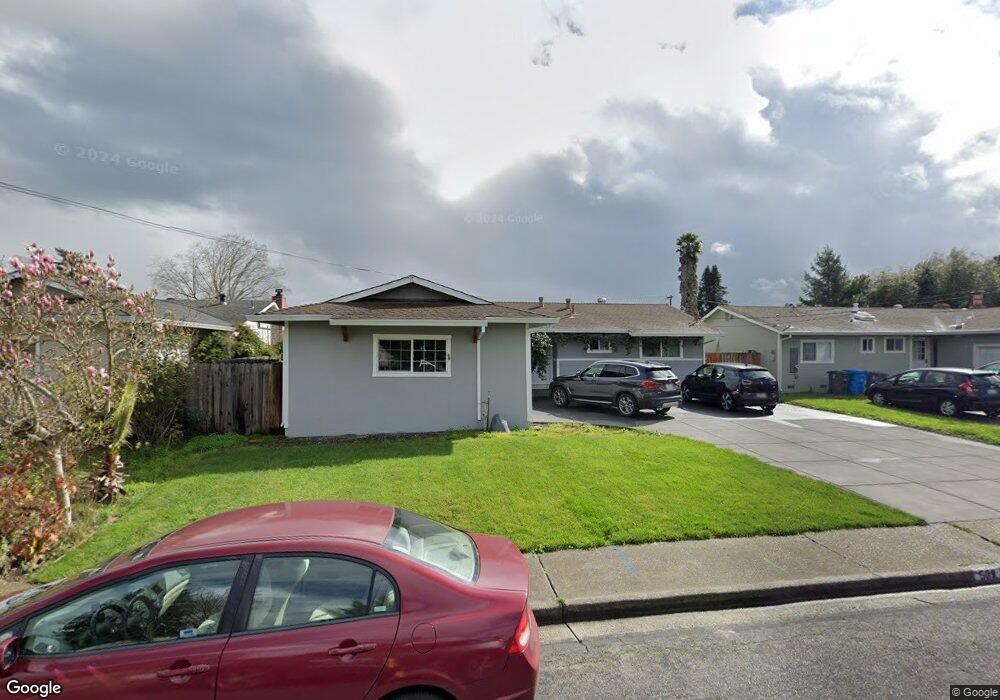
569 Anson Ave Rohnert Park, CA 94928
Estimated Value: $598,564 - $670,000
3
Beds
2
Baths
1,100
Sq Ft
$578/Sq Ft
Est. Value
About This Home
This home is located at 569 Anson Ave, Rohnert Park, CA 94928 and is currently estimated at $635,391, approximately $577 per square foot. 569 Anson Ave is a home located in Sonoma County with nearby schools including Rancho Cotate High School, Cross & Crown Lutheran School, and Bridghaven.
Ownership History
Date
Name
Owned For
Owner Type
Purchase Details
Closed on
Nov 28, 2012
Sold by
Prothero Donna Lee and Emma L Troudt Revocable Living
Bought by
Bailey Mark A and Bailey Ashley
Current Estimated Value
Home Financials for this Owner
Home Financials are based on the most recent Mortgage that was taken out on this home.
Original Mortgage
$244,000
Outstanding Balance
$168,733
Interest Rate
3.33%
Mortgage Type
New Conventional
Estimated Equity
$466,658
Purchase Details
Closed on
Feb 1, 1994
Sold by
Troudt Emma L
Bought by
Troudt Emma L
Create a Home Valuation Report for This Property
The Home Valuation Report is an in-depth analysis detailing your home's value as well as a comparison with similar homes in the area
Home Values in the Area
Average Home Value in this Area
Purchase History
| Date | Buyer | Sale Price | Title Company |
|---|---|---|---|
| Bailey Mark A | $279,000 | Fidelity National Title Co | |
| Troudt Emma L | -- | -- |
Source: Public Records
Mortgage History
| Date | Status | Borrower | Loan Amount |
|---|---|---|---|
| Open | Bailey Mark A | $244,000 |
Source: Public Records
Tax History Compared to Growth
Tax History
| Year | Tax Paid | Tax Assessment Tax Assessment Total Assessment is a certain percentage of the fair market value that is determined by local assessors to be the total taxable value of land and additions on the property. | Land | Improvement |
|---|---|---|---|---|
| 2025 | $3,894 | $343,557 | $137,298 | $206,259 |
| 2024 | $3,894 | $336,821 | $134,606 | $202,215 |
| 2023 | $3,894 | $330,217 | $131,967 | $198,250 |
| 2022 | $3,814 | $323,743 | $129,380 | $194,363 |
| 2021 | $4,576 | $317,396 | $126,844 | $190,552 |
| 2020 | $4,627 | $314,143 | $125,544 | $188,599 |
| 2019 | $4,574 | $307,984 | $123,083 | $184,901 |
| 2018 | $4,498 | $301,946 | $120,670 | $181,276 |
| 2017 | $4,433 | $296,026 | $118,304 | $177,722 |
| 2016 | $4,277 | $290,223 | $115,985 | $174,238 |
| 2015 | $4,190 | $285,864 | $114,243 | $171,621 |
| 2014 | $4,163 | $280,266 | $112,006 | $168,260 |
Source: Public Records
Map
Nearby Homes
- 530 Anson Ct
- 7301 Willlowglen Dr
- 7316 Willowglen Dr
- 566 Santa Alicia Dr
- 478 Santa Alicia Dr
- 77 Walnut Cir
- 138 Walnut Cir
- 746 Bernadette Ave
- 7530 Bernice Ave
- 6440 Country Club Dr
- 211 Apple Ln
- 229 Arlen Dr
- 950 Santa Alicia Dr
- 6469 Meadow Pines Ave
- 7449 Adrian Dr
- 928 Civic Center Dr
- 21 Avram Ave
- 7103 Camino Colegio Unit 55
- 6454 Amberwood St
- 11 Avram Ave