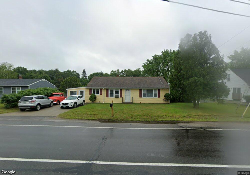
569 Daniel Webster Hwy MerriMacK, NH 03054
Estimated Value: $477,000 - $501,000
2
Beds
2
Baths
1,716
Sq Ft
$285/Sq Ft
Est. Value
About This Home
This home is located at 569 Daniel Webster Hwy, MerriMacK, NH 03054 and is currently estimated at $488,527, approximately $284 per square foot. 569 Daniel Webster Hwy is a home located in Hillsborough County with nearby schools including Reeds Ferry School, James Mastricola Upper Elementary School, and Merrimack Middle School.
Ownership History
Date
Name
Owned For
Owner Type
Purchase Details
Closed on
Nov 9, 2023
Sold by
Killpatrick James R and Killpatrick Janet M
Bought by
Killpatrick
Current Estimated Value
Purchase Details
Closed on
Nov 2, 1977
Bought by
Killpartrick James and Killpartrick Janet
Create a Home Valuation Report for This Property
The Home Valuation Report is an in-depth analysis detailing your home's value as well as a comparison with similar homes in the area
Home Values in the Area
Average Home Value in this Area
Purchase History
| Date | Buyer | Sale Price | Title Company |
|---|---|---|---|
| Killpatrick | -- | None Available | |
| Killpartrick James | -- | -- |
Source: Public Records
Mortgage History
| Date | Status | Borrower | Loan Amount |
|---|---|---|---|
| Previous Owner | Killpartrick James | $160,743 | |
| Previous Owner | Killpartrick James | $174,200 | |
| Previous Owner | Killpartrick James | $151,000 | |
| Previous Owner | Killpartrick James | $134,201 |
Source: Public Records
Tax History Compared to Growth
Tax History
| Year | Tax Paid | Tax Assessment Tax Assessment Total Assessment is a certain percentage of the fair market value that is determined by local assessors to be the total taxable value of land and additions on the property. | Land | Improvement |
|---|---|---|---|---|
| 2024 | $5,818 | $281,200 | $133,000 | $148,200 |
| 2023 | $5,469 | $281,200 | $133,000 | $148,200 |
| 2022 | $4,667 | $268,500 | $133,000 | $135,500 |
| 2021 | $4,610 | $268,500 | $133,000 | $135,500 |
| 2020 | $4,793 | $199,200 | $102,100 | $97,100 |
| 2019 | $4,855 | $201,200 | $102,100 | $99,100 |
| 2018 | $4,853 | $201,200 | $102,100 | $99,100 |
| 2017 | $4,702 | $201,200 | $102,100 | $99,100 |
| 2016 | $4,585 | $201,200 | $102,100 | $99,100 |
| 2015 | $4,798 | $194,100 | $100,000 | $94,100 |
| 2014 | $4,676 | $194,100 | $100,000 | $94,100 |
| 2013 | $4,641 | $194,100 | $100,000 | $94,100 |
Source: Public Records
Map
Nearby Homes
- 1 Pleasant St
- 19 Vista Way
- 10 Kingston Ct Unit 10
- 11 Essex Green Ct
- 22 Essex Green Ct
- 12 Clinton Ct
- 38 Mallard Point
- 29 Bedford Rd
- 22 Clay St
- 490 Charles Bancroft Hwy
- 1 Tallarico St Unit 14
- 0 Tallarico St Unit 3 5032471
- 0 Tallarico St Unit 5 5032751
- 0 Tallarico St Unit 25 5043170
- 0 Tallarico St Unit 10 5044310
- 0 Tallarico St Unit 12 5033131
- 0 Tallarico St Unit Lot 11 5056385
- 22 Kimberly Dr
- 5 Barbie Ct
- 98 Indian Rock Rd
- 567 Daniel Webster Hwy
- 571 Daniel Webster Hwy
- 573 Daniel Webster Hwy
- 3 Rainbow Ave
- 5 Rainbow Ave
- 1 Rainbow Ave
- 565 Daniel Webster Hwy
- 575 Dw Hwy
- 575 Daniel Webster Hwy
- 7 Rainbow Ave
- 3 Pine St
- 9 Rainbow Ave
- 4 Glen Forest Dr
- 6 Glen Forest Dr
- 11 Rainbow Ave
- 2 Glen Forest Dr
- 579 Daniels Webster Hwy
- 7 Pine St
- 579 Daniel Webster Hwy
- 579 Daniel Webster Hwy Unit 1