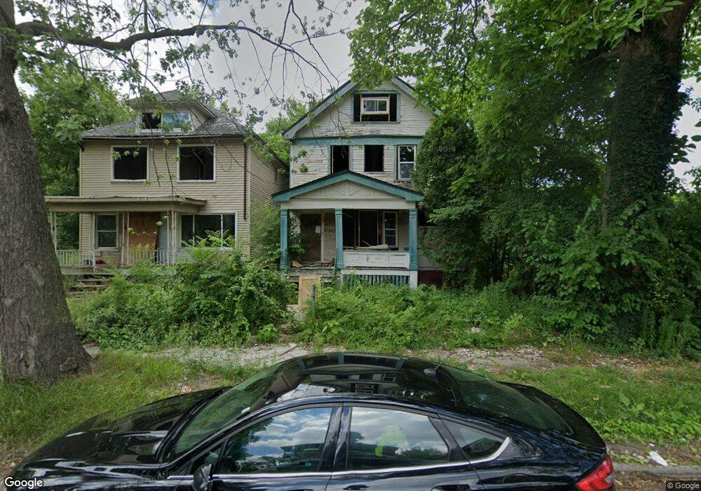
569 Rosedale Ct Detroit, MI 48202
Gateway Community NeighborhoodEstimated Value: $105,000 - $191,000
--
Bed
1
Bath
1,387
Sq Ft
$105/Sq Ft
Est. Value
About This Home
This home is located at 569 Rosedale Ct, Detroit, MI 48202 and is currently estimated at $145,089, approximately $104 per square foot. 569 Rosedale Ct is a home located in Wayne County with nearby schools including Golightly Education Center, Charles L. Spain Elementary-Middle School, and Edward 'Duke' Ellington Conservatory of Music and Art.
Ownership History
Date
Name
Owned For
Owner Type
Purchase Details
Closed on
Jan 2, 2023
Sold by
19133 Northlawn Llc
Bought by
Retro Revenue Llc
Current Estimated Value
Purchase Details
Closed on
May 28, 2021
Sold by
Detroit Land Bank Authority
Bought by
19133 Northlawn Llc
Purchase Details
Closed on
Jan 13, 2016
Sold by
Wayne County Treasurer
Bought by
Detroit Land Bank Authority
Purchase Details
Closed on
Nov 16, 2009
Sold by
Wojtowicz Raymond J
Bought by
Hogans Holdings
Create a Home Valuation Report for This Property
The Home Valuation Report is an in-depth analysis detailing your home's value as well as a comparison with similar homes in the area
Home Values in the Area
Average Home Value in this Area
Purchase History
| Date | Buyer | Sale Price | Title Company |
|---|---|---|---|
| Retro Revenue Llc | $50,000 | None Listed On Document | |
| 19133 Northlawn Llc | $12,900 | None Available | |
| Detroit Land Bank Authority | -- | None Available | |
| Hogans Holdings | $1,100 | None Available |
Source: Public Records
Tax History Compared to Growth
Tax History
| Year | Tax Paid | Tax Assessment Tax Assessment Total Assessment is a certain percentage of the fair market value that is determined by local assessors to be the total taxable value of land and additions on the property. | Land | Improvement |
|---|---|---|---|---|
| 2025 | $2,276 | $2,000 | $0 | $0 |
| 2024 | $2,276 | $26,900 | $0 | $0 |
| 2023 | $1,048 | $19,700 | $0 | $0 |
| 2022 | $1,114 | $10,000 | $0 | $0 |
| 2021 | $2,040 | $0 | $0 | $0 |
| 2020 | $0 | $0 | $0 | $0 |
| 2019 | $669 | $0 | $0 | $0 |
| 2018 | $0 | $0 | $0 | $0 |
| 2017 | $599 | $0 | $0 | $0 |
| 2016 | $240 | $0 | $0 | $0 |
| 2015 | $599 | $9,800 | $0 | $0 |
| 2013 | $580 | $11,643 | $0 | $0 |
| 2010 | -- | $15,440 | $513 | $14,927 |
Source: Public Records
Map
Nearby Homes
- 545 Rosedale Ct
- 537 Rosedale Ct
- 616 Englewood St
- 520 Englewood St
- 355 Rosedale Ct
- 224 Tennyson St
- 526 Harmon St
- 291 Englewood St
- 267 Harmon St
- 534 Trowbridge St
- 261 Woodland St
- 553 Belmont St
- 239 Trowbridge St
- 97 Tennyson St
- 10288 Cameron St
- 127 Rosedale Ct
- 10270 Cameron St
- 146 Harmon St
- 120 Woodland St
- 227 Belmont St
- 575 Rosedale Ct
- 563 Rosedale Ct
- 581 Rosedale Ct
- 557 Rosedale Ct
- 587 Rosedale Ct
- 593 Rosedale Ct
- 568 Englewood St
- 574 Englewood St
- 592 Englewood St
- 580 Englewood St
- 550 Englewood St
- 586 Englewood St
- 531 Rosedale Ct
- 570 Rosedale Ct
- 578 Rosedale Ct
- 611 Rosedale Ct
- 598 Englewood St
- 536 Englewood St
- 527 Rosedale Ct
- 546 Rosedale Ct