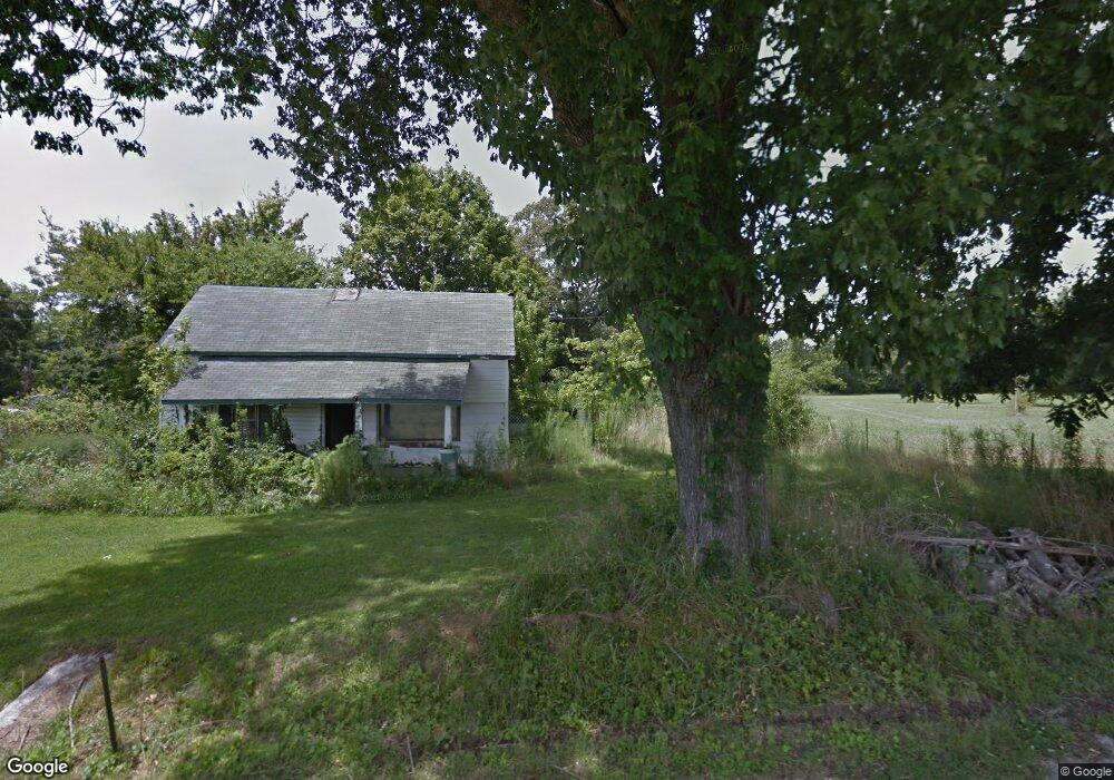
569 Shady Grove Rd Manchester, TN 37355
Estimated Value: $18,061 - $305,000
--
Bed
1
Bath
1,881
Sq Ft
$94/Sq Ft
Est. Value
About This Home
This home is located at 569 Shady Grove Rd, Manchester, TN 37355 and is currently estimated at $177,515, approximately $94 per square foot. 569 Shady Grove Rd is a home located in Coffee County with nearby schools including East Coffee Elementary School, Coffee County Middle School, and Coffee County Central High School.
Ownership History
Date
Name
Owned For
Owner Type
Purchase Details
Closed on
Aug 2, 2018
Sold by
Rackley Donald and Rackley Jovella
Bought by
Bunch William Travis and Bunch Sheila K
Current Estimated Value
Purchase Details
Closed on
Jun 7, 2018
Sold by
Bocchieri Salvatore and Bocchieri Joan
Bought by
Kennedy Deanna Darlene
Purchase Details
Closed on
Mar 7, 2014
Sold by
Bocchieri Salvatore
Bought by
Rackley Donald and Rackley Jovella
Purchase Details
Closed on
Dec 27, 1988
Purchase Details
Closed on
Apr 7, 1987
Create a Home Valuation Report for This Property
The Home Valuation Report is an in-depth analysis detailing your home's value as well as a comparison with similar homes in the area
Home Values in the Area
Average Home Value in this Area
Purchase History
| Date | Buyer | Sale Price | Title Company |
|---|---|---|---|
| Bunch William Travis | $10,000 | Gateway Title Services Llc | |
| Kennedy Deanna Darlene | $3,600 | None Available | |
| Rackley Donald | $5,000 | -- | |
| -- | $20,000 | -- | |
| -- | $37,500 | -- |
Source: Public Records
Tax History Compared to Growth
Tax History
| Year | Tax Paid | Tax Assessment Tax Assessment Total Assessment is a certain percentage of the fair market value that is determined by local assessors to be the total taxable value of land and additions on the property. | Land | Improvement |
|---|---|---|---|---|
| 2024 | $52 | $2,250 | $2,250 | -- |
| 2023 | $52 | $2,250 | $0 | $0 |
| 2022 | $52 | $2,250 | $2,250 | $0 |
| 2021 | $47 | $1,600 | $1,600 | $0 |
| 2020 | $47 | $1,600 | $1,600 | $0 |
| 2019 | $47 | $1,600 | $1,600 | $0 |
| 2018 | $47 | $1,600 | $1,600 | $0 |
| 2017 | $73 | $2,225 | $2,225 | $0 |
| 2016 | $73 | $2,225 | $2,225 | $0 |
| 2015 | $73 | $2,225 | $2,225 | $0 |
| 2014 | $72 | $2,213 | $0 | $0 |
Source: Public Records
Map
Nearby Homes
- 2498 Sp Anderson Rd
- 667 Pete Sain Rd
- 7807 McMinnville Hwy Unit 7807
- 0 Pete Sain Rd
- 0 Ramsey Rd
- 363 Willow Brook Dr
- 300 Willow Brook Dr
- 0 Mcafee Rd
- 2635 Pete Sain Rd
- 0 Mcafee E Unit RTC2865293
- 967 Mud Creek Rd
- 1037 Mcafee Rd
- 837 Circle Dr
- 781 Circle Dr
- 670 Old McMinnville Hwy
- 1694 Mcafee Rd
- 89 Saddle St
- 231 Tom Johnson Rd
- 4282 McMinnville Hwy Unit 4270
- 105 Barbara Spears Rd
- 551 Shady Grove Rd
- 637 Shady Grove Rd
- 490 Shady Grove Rd
- 487 Shady Grove Rd
- 1296 Summitville Rd
- 397 Shady Grove Rd
- 380 Shady Grove Rd
- 351 Shady Grove Rd
- 241 Onderka Ln
- 1230 Summitville Rd
- 830 Shady Grove Rd
- 1588 Summitville Rd
- 1223 Summitville Rd
- 1445 Summitville Rd
- 287 Shady Grove Rd
- 1477 Summitville Rd
- 863 Shady Grove Rd
- 667 Old Pocahontas Rd
- 1497 Summitville Rd
- 1742 Summitville Rd