


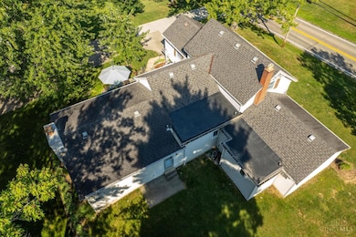


5695 Jessup Rd Cincinnati, OH 45247
White Oak West NeighborhoodEstimated payment $2,439/month
Highlights
- Wooded Lot
- Radiant Floor
- No HOA
- Transitional Architecture
- Main Floor Bedroom
- 4 Car Garage
About This Home
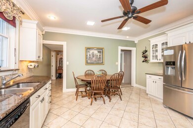
Charming farmhouse feel on nearly an acre! Built in 1880, this home has been lovingly cared for by the same owners for over 50 years. Large kitchen tastefully remodeled with granite countertops, upgraded stainless steel appliances with gas stove! The generous sized first floor primary suite features full updated bath with spacious closet space. Enjoy peaceful mornings or incredible sunsets on the patio overlooking well manicured backyard. The driveway offers plenty of parking and leads to the large detached garage for the car enthusiast or tinkerer! This home is a wonderful blend of historic charm and modern updates...a must see!
Home Details
Home Type
- Single Family
Est. Annual Taxes
- $4,336
Year Built
- Built in 1880
Lot Details
- 0.84 Acre Lot
- Lot Dimensions are 220 x 171
- Wooded Lot
Parking
- 4 Car Garage
- Driveway
Home Design
- Transitional Architecture
- Stone Foundation
- Shingle Roof
- Vinyl Siding
Interior Spaces
- 2,449 Sq Ft Home
- 1.5-Story Property
- Ceiling Fan
- Recessed Lighting
- Chandelier
- Wood Burning Fireplace
- Double Pane Windows
- Vinyl Clad Windows
- Window Treatments
- Family Room with Fireplace
- Unfinished Basement
- Partial Basement
- Fire and Smoke Detector
Kitchen
- Eat-In Kitchen
- Oven or Range
- Gas Cooktop
- Microwave
- Dishwasher
- Disposal
Flooring
- Radiant Floor
- Concrete
- Tile
- Vinyl
Bedrooms and Bathrooms
- 3 Bedrooms
- Main Floor Bedroom
- Walk-In Closet
Outdoor Features
- Patio
- Porch
Utilities
- Cooling System Mounted In Outer Wall Opening
- Window Unit Cooling System
- Baseboard Heating
- 220 Volts
- Gas Available at Street
- Gas Water Heater
- Septic Tank
- Cable TV Available
Community Details
- No Home Owners Association
Map
Home Values in the Area
Average Home Value in this Area
Tax History
| Year | Tax Paid | Tax Assessment Tax Assessment Total Assessment is a certain percentage of the fair market value that is determined by local assessors to be the total taxable value of land and additions on the property. | Land | Improvement |
|---|---|---|---|---|
| 2024 | $4,337 | $81,474 | $19,415 | $62,059 |
| 2023 | $4,352 | $81,474 | $19,415 | $62,059 |
| 2022 | $3,971 | $60,708 | $20,384 | $40,324 |
| 2021 | $3,646 | $60,708 | $20,384 | $40,324 |
| 2020 | $3,676 | $60,708 | $20,384 | $40,324 |
| 2019 | $3,865 | $57,817 | $19,415 | $38,402 |
| 2018 | $3,443 | $57,817 | $19,415 | $38,402 |
| 2017 | $3,258 | $57,817 | $19,415 | $38,402 |
| 2016 | $2,545 | $44,454 | $19,222 | $25,232 |
| 2015 | $2,567 | $44,454 | $19,222 | $25,232 |
| 2014 | $2,571 | $44,454 | $19,222 | $25,232 |
| 2013 | $2,429 | $44,902 | $19,415 | $25,487 |
Property History
| Date | Event | Price | List to Sale | Price per Sq Ft |
|---|---|---|---|---|
| 11/13/2025 11/13/25 | Pending | -- | -- | -- |
| 10/21/2025 10/21/25 | For Sale | $395,000 | -- | $161 / Sq Ft |
Purchase History
| Date | Type | Sale Price | Title Company |
|---|---|---|---|
| Warranty Deed | -- | None Available | |
| Interfamily Deed Transfer | -- | Elite Title Agency Inc |
Mortgage History
| Date | Status | Loan Amount | Loan Type |
|---|---|---|---|
| Previous Owner | $71,500 | Unknown |
Source: MLS of Greater Cincinnati (CincyMLS)
MLS Number: 1859297
APN: 550-0202-0110
Disclaimer: Certain information contained herein is derived from information provided by parties other than Homes.com. All information provided is deemed reliable, but is not guaranteed to be accurate and should be independently verified.
![]() The data relating to real estate for sale on this website comes in part from the Broker Reciprocity programs of the MLS of Greater Cincinnati, Inc.. Those listings held by brokerage firms other than Ten-X are marked with the Broker Reciprocity logo and house icon. The properties displayed may not be all of the properties available through Broker Reciprocity.
The data relating to real estate for sale on this website comes in part from the Broker Reciprocity programs of the MLS of Greater Cincinnati, Inc.. Those listings held by brokerage firms other than Ten-X are marked with the Broker Reciprocity logo and house icon. The properties displayed may not be all of the properties available through Broker Reciprocity.
IDX information is provided exclusively for personal, non-commercial use, and may not be used for any purpose other than to identify prospective properties consumers may be interested in purchasing.
Information is deemed reliable but not guaranteed.
Ten-X does not display the entire Cincinnati MLS Broker Reciprocity™ database on this web site. The listings of some real estate brokerage firms have been excluded.
Copyright 2025, MLS of Greater Cincinnati, Inc. All rights reserved
- 5991 Gaines Rd
- 6051 Shelrich Ct
- 5998 Brierly Ridge Dr
- 5980 Brierly Creek Rd
- 5160 Jessup Rd
- 6044 Eden Roc Place
- 5563 Haft Rd
- 6163 Sheed Rd
- 6130 W Fork Rd
- 6230 Castle Stone Ln
- 5804 Cedaridge Dr
- 4538 Philnoll Dr
- 4593 Farview Ln
- 6761 Schweitzerhoff Rd
- 6676 Daleview Rd
- 8211 Fawn Lake Ct
- 4600 Farcrest Ct
- 6662 Daleview Rd
- 6306 W Fork Rd
- 5410 Desertgold Dr
