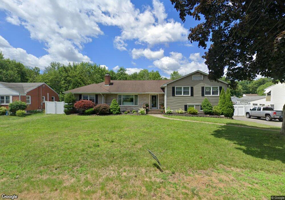
57 Barstow Dr Wethersfield, CT 06109
Estimated Value: $445,000 - $498,400
3
Beds
4
Baths
2,075
Sq Ft
$230/Sq Ft
Est. Value
About This Home
This home is located at 57 Barstow Dr, Wethersfield, CT 06109 and is currently estimated at $477,350, approximately $230 per square foot. 57 Barstow Dr is a home located in Hartford County with nearby schools including Charles Wright School, Silas Deane Middle School, and Wethersfield High School.
Ownership History
Date
Name
Owned For
Owner Type
Purchase Details
Closed on
Jul 1, 2009
Sold by
Wethersfield Town Of
Bought by
Mcgrath Sean P and Mcgrath Patricia E
Current Estimated Value
Home Financials for this Owner
Home Financials are based on the most recent Mortgage that was taken out on this home.
Original Mortgage
$151,000
Interest Rate
4.93%
Purchase Details
Closed on
Mar 1, 1999
Sold by
Juliano James J
Bought by
Mcgrath Sean P
Home Financials for this Owner
Home Financials are based on the most recent Mortgage that was taken out on this home.
Original Mortgage
$128,000
Interest Rate
6.78%
Purchase Details
Closed on
Nov 30, 1990
Sold by
Larkin Peter J
Bought by
Casale Jelsa M
Create a Home Valuation Report for This Property
The Home Valuation Report is an in-depth analysis detailing your home's value as well as a comparison with similar homes in the area
Home Values in the Area
Average Home Value in this Area
Purchase History
| Date | Buyer | Sale Price | Title Company |
|---|---|---|---|
| Mcgrath Sean P | $1,050 | -- | |
| Mcgrath Sean P | $160,000 | -- | |
| Casale Jelsa M | $239,900 | -- |
Source: Public Records
Mortgage History
| Date | Status | Borrower | Loan Amount |
|---|---|---|---|
| Closed | Casale Jelsa M | $151,000 | |
| Previous Owner | Casale Jelsa M | $145,000 | |
| Previous Owner | Casale Jelsa M | $128,000 |
Source: Public Records
Tax History Compared to Growth
Tax History
| Year | Tax Paid | Tax Assessment Tax Assessment Total Assessment is a certain percentage of the fair market value that is determined by local assessors to be the total taxable value of land and additions on the property. | Land | Improvement |
|---|---|---|---|---|
| 2025 | $12,581 | $305,220 | $74,970 | $230,250 |
| 2024 | $8,528 | $197,320 | $65,040 | $132,280 |
| 2023 | $8,244 | $197,320 | $65,040 | $132,280 |
| 2022 | $8,106 | $197,320 | $65,040 | $132,280 |
| 2021 | $8,025 | $197,320 | $65,040 | $132,280 |
| 2020 | $8,029 | $197,320 | $65,040 | $132,280 |
| 2019 | $7,657 | $187,950 | $65,040 | $122,910 |
| 2018 | $7,605 | $186,500 | $67,300 | $119,200 |
| 2017 | $7,417 | $186,500 | $67,300 | $119,200 |
| 2016 | $7,188 | $186,500 | $67,300 | $119,200 |
| 2015 | $7,122 | $186,500 | $67,300 | $119,200 |
| 2014 | $6,852 | $186,500 | $67,300 | $119,200 |
Source: Public Records
Map
Nearby Homes
- 193 Wolcott Hill Rd Unit 195
- 55 Rutledge Rd
- 11 Yale St
- 80 Spruce St
- 26 Tifton Rd
- 442 Wolcott Hill Rd
- 133 Wells Farm Dr
- 67 Oakdale St
- 373 Wells Rd
- 14 Fernwood St
- 358 Ridge Rd
- 53 Wolcott Hill Rd Unit C23
- 19 Albert Ave
- 481 Ridge Rd
- 18 Avalon Place
- 219 Crest St
- 317 Garden St Unit 319
- 51 Olney Rd
- 9 Avalon Place
- 615 Ridge Rd