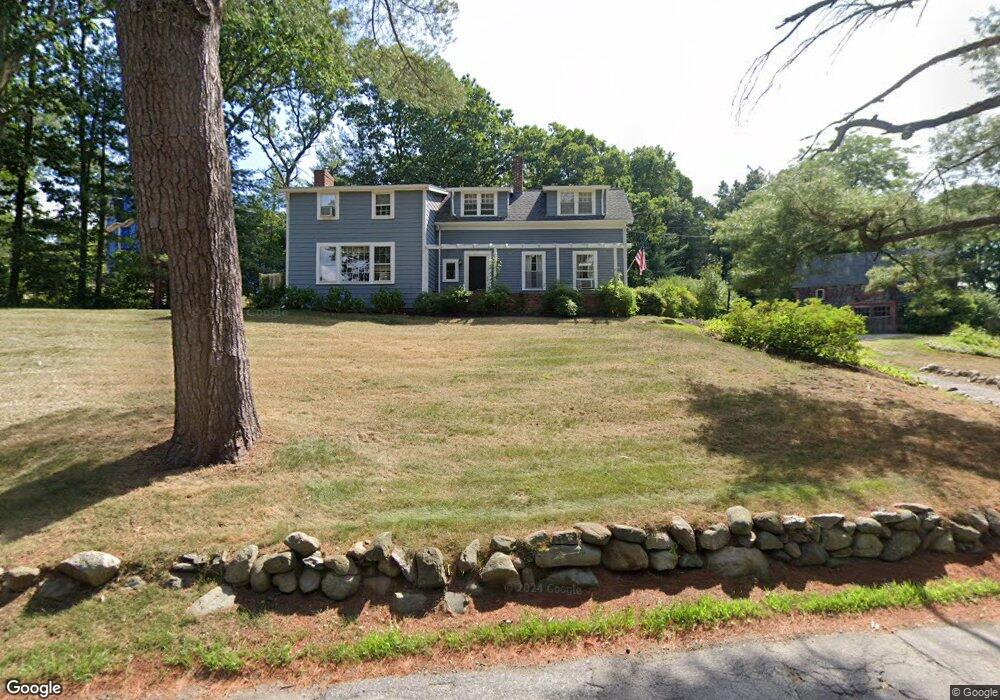
57 Brookside Rd Needham, MA 02492
Estimated Value: $1,235,000 - $1,381,000
4
Beds
2
Baths
2,398
Sq Ft
$540/Sq Ft
Est. Value
About This Home
This home is located at 57 Brookside Rd, Needham, MA 02492 and is currently estimated at $1,296,059, approximately $540 per square foot. 57 Brookside Rd is a home located in Norfolk County with nearby schools including Sunita L. Williams Elementary School, High Rock Middle School, and Pollard Middle School.
Ownership History
Date
Name
Owned For
Owner Type
Purchase Details
Closed on
Nov 12, 2025
Sold by
Murphy Margaret G
Bought by
Margaret G Murphy Ret and Murphy
Current Estimated Value
Purchase Details
Closed on
Nov 20, 2023
Sold by
Murphy Michael F
Bought by
Murphy Margaret G
Purchase Details
Closed on
Aug 23, 1995
Sold by
Hobson Edmund W and Hobson Shelley S
Bought by
Murphy Michael F and Murphy Margaretg
Purchase Details
Closed on
Aug 16, 1990
Sold by
Waters Joanne M
Bought by
Hobson W Edmund
Create a Home Valuation Report for This Property
The Home Valuation Report is an in-depth analysis detailing your home's value as well as a comparison with similar homes in the area
Home Values in the Area
Average Home Value in this Area
Purchase History
| Date | Buyer | Sale Price | Title Company |
|---|---|---|---|
| Margaret G Murphy Ret | -- | -- | |
| Murphy Margaret G | -- | None Available | |
| Murphy Margaret G | -- | None Available | |
| Murphy Michael F | $374,000 | -- | |
| Murphy Michael F | $374,000 | -- | |
| Hobson W Edmund | $349,600 | -- | |
| Murphy Michael F | $374,000 | -- | |
| Hobson W Edmund | $349,600 | -- |
Source: Public Records
Mortgage History
| Date | Status | Borrower | Loan Amount |
|---|---|---|---|
| Previous Owner | Hobson W Edmund | $402,000 | |
| Previous Owner | Hobson W Edmund | $414,000 | |
| Previous Owner | Hobson W Edmund | $290,000 |
Source: Public Records
Tax History
| Year | Tax Paid | Tax Assessment Tax Assessment Total Assessment is a certain percentage of the fair market value that is determined by local assessors to be the total taxable value of land and additions on the property. | Land | Improvement |
|---|---|---|---|---|
| 2025 | $11,713 | $1,105,000 | $764,400 | $340,600 |
| 2024 | $10,691 | $853,900 | $495,900 | $358,000 |
| 2023 | $10,798 | $828,100 | $495,900 | $332,200 |
| 2022 | $10,546 | $788,800 | $469,300 | $319,500 |
| 2021 | $10,278 | $788,800 | $469,300 | $319,500 |
| 2020 | $10,126 | $810,700 | $469,300 | $341,400 |
| 2019 | $9,435 | $761,500 | $429,100 | $332,400 |
| 2018 | $9,047 | $761,500 | $429,100 | $332,400 |
| 2017 | $8,604 | $723,600 | $429,100 | $294,500 |
| 2016 | $8,350 | $723,600 | $429,100 | $294,500 |
| 2015 | $8,169 | $723,600 | $429,100 | $294,500 |
| 2014 | $7,850 | $674,400 | $391,800 | $282,600 |
Source: Public Records
Map
Nearby Homes
- 70 Briarwood Cir
- 12 Hill St
- 151 Oakland St
- 48 Taylor St
- 36 Eliot Rd
- 102 Jarvis Cir Unit 102
- 81 Parish Rd
- 34 Pershing Rd
- 15 Mackintosh Ave
- 15 Alden Rd
- 345 Central Ave
- 19 Mason Rd
- 3 Hancock Rd
- 379 Hunnewell St Unit 379
- 5 Homsy Ln
- 140 Hillside Ave
- 140 Hillside Ave Unit a
- 3 Crescent Rd
- 134 Hillside Ave Unit 134
- 132 Hillside Ave
- 68 Clarke Cir
- 39 Brookside Rd
- 60 Brookside Rd
- 64 Clarke Cir
- 74 Brookside Rd
- 44 Brookside Rd
- 33 Brookside Rd
- 72 Clarke Cir
- 83 Brookside Rd
- 38 Brookside Rd
- 69 Clarke Cir
- 30 Brookside Rd
- 78 Clarke Cir
- 78 Brookside Rd
- 52 Clarke Cir
- 24 Brookside Rd
- 51 Clarke Cir
- 109 Brookside Rd
- 94 Brookside Rd
- 103 Brookside Rd
Your Personal Tour Guide
Ask me questions while you tour the home.