L
Seller's Agent in 2026
Lizneirie Rodriguez
Coldwell Banker Realty
(860) 888-6204
1 in this area
20 Total Sales
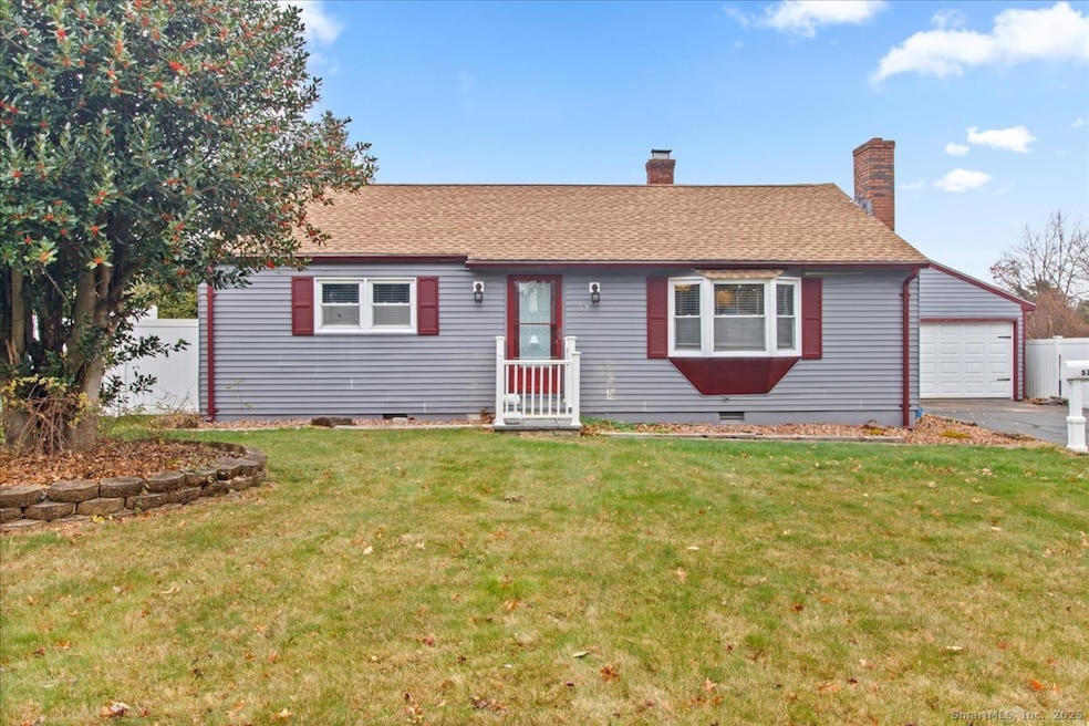
Welcome to 57 Concord Circle in Wethersfield. This well-maintained home features 3 bedrooms, 2 full baths, main-level laundry just off the kitchen, a paved driveway, and a detached 2-car garage. Conveniently located near town amenities, parks, dining, and commuter access. A great opportunity to make this property your next home.
Last Agent to Sell the Property
Coldwell Banker Realty Brokerage Phone: (860) 888-6204 License #RES.0828970 Listed on: 11/29/2025

| Date | Type | Sale Price | Title Company |
|---|---|---|---|
| Warranty Deed | $280,000 | -- | |
| Quit Claim Deed | -- | -- | |
| Warranty Deed | $119,000 | -- | |
| Deed | $162,500 | -- |
| Date | Status | Loan Amount | Loan Type |
|---|---|---|---|
| Previous Owner | $182,000 | No Value Available | |
| Previous Owner | $153,000 | No Value Available | |
| Previous Owner | $126,100 | No Value Available | |
| Previous Owner | $115,430 | Purchase Money Mortgage |
| Date | Event | Price | List to Sale | Price per Sq Ft |
|---|---|---|---|---|
| 01/14/2026 01/14/26 | Sold | $280,000 | -6.6% | $190 / Sq Ft |
| 12/08/2025 12/08/25 | Pending | -- | -- | -- |
| 11/29/2025 11/29/25 | For Sale | $299,900 | -- | $204 / Sq Ft |
| Year | Tax Paid | Tax Assessment Tax Assessment Total Assessment is a certain percentage of the fair market value that is determined by local assessors to be the total taxable value of land and additions on the property. | Land | Improvement |
|---|---|---|---|---|
| 2025 | $8,829 | $214,190 | $89,080 | $125,110 |
| 2024 | $5,832 | $134,930 | $62,510 | $72,420 |
| 2023 | $5,637 | $134,930 | $62,510 | $72,420 |
| 2022 | $5,543 | $134,930 | $62,510 | $72,420 |
| 2021 | $5,488 | $134,930 | $62,510 | $72,420 |
| 2020 | $5,490 | $134,930 | $62,510 | $72,420 |
| 2019 | $5,497 | $134,930 | $62,510 | $72,420 |
| 2018 | $5,358 | $131,400 | $61,300 | $70,100 |
| 2017 | $5,226 | $131,400 | $61,300 | $70,100 |
| 2016 | $5,064 | $131,400 | $61,300 | $70,100 |
| 2015 | $5,018 | $131,400 | $61,300 | $70,100 |
| 2014 | $4,828 | $131,400 | $61,300 | $70,100 |
L
Seller's Agent in 2026
Lizneirie Rodriguez
Coldwell Banker Realty
(860) 888-6204
1 in this area
20 Total Sales
Buyer's Agent in 2026
Guillermo Araujo
Five Stars Realty
(860) 794-5353
4 in this area
202 Total Sales
Source: SmartMLS
MLS Number: 24142416
APN: WETH-000065-000000-000008
Disclaimer: Certain information contained herein is derived from information provided by parties other than Homes.com. All information provided is deemed reliable, but is not guaranteed to be accurate and should be independently verified.
![]() IDX information is provided exclusively for personal, non-commercial use, and may not be used for any purpose other than to identify prospective properties consumers may be interested in purchasing. Information is deemed reliable but not guaranteed.
IDX information is provided exclusively for personal, non-commercial use, and may not be used for any purpose other than to identify prospective properties consumers may be interested in purchasing. Information is deemed reliable but not guaranteed.
Ask me questions while you tour the home.