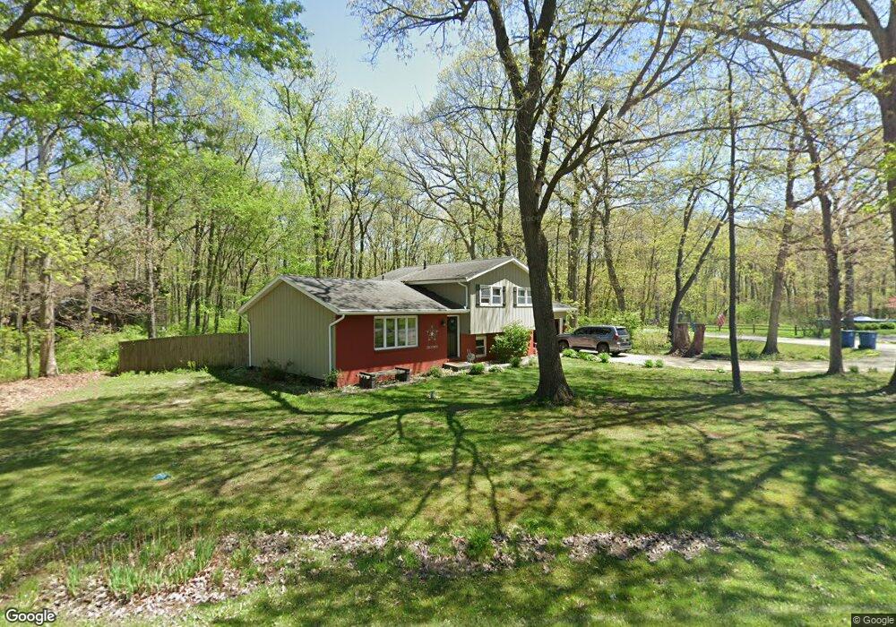
57 Deerpath Rd Valparaiso, IN 46385
Porter County NeighborhoodEstimated Value: $308,369 - $407,000
Studio
2
Baths
1,812
Sq Ft
$197/Sq Ft
Est. Value
About This Home
This home is located at 57 Deerpath Rd, Valparaiso, IN 46385 and is currently estimated at $357,092, approximately $197 per square foot. 57 Deerpath Rd is a home located in Porter County with nearby schools including Porter Lakes Elementary School, Boone Grove Elementary School, and Boone Grove Middle School.
Ownership History
Date
Name
Owned For
Owner Type
Purchase Details
Closed on
May 31, 2012
Sold by
Miller John R and Miller Leeann
Bought by
Miller Zachary R
Current Estimated Value
Home Financials for this Owner
Home Financials are based on the most recent Mortgage that was taken out on this home.
Original Mortgage
$104,000
Interest Rate
3.92%
Mortgage Type
New Conventional
Purchase Details
Closed on
Nov 28, 2011
Sold by
Miller John R and Miller Living Trust
Bought by
Miller John R and Miller Leeann
Create a Home Valuation Report for This Property
The Home Valuation Report is an in-depth analysis detailing your home's value as well as a comparison with similar homes in the area
Home Values in the Area
Average Home Value in this Area
Purchase History
| Date | Buyer | Sale Price | Title Company |
|---|---|---|---|
| Miller Zachary R | -- | Fidelity National Title Co | |
| Miller John R | -- | None Available |
Source: Public Records
Mortgage History
| Date | Status | Borrower | Loan Amount |
|---|---|---|---|
| Closed | Miller Zachary R | $104,000 |
Source: Public Records
Tax History
| Year | Tax Paid | Tax Assessment Tax Assessment Total Assessment is a certain percentage of the fair market value that is determined by local assessors to be the total taxable value of land and additions on the property. | Land | Improvement |
|---|---|---|---|---|
| 2024 | $1,612 | $243,900 | $38,300 | $205,600 |
| 2023 | $1,472 | $225,300 | $34,800 | $190,500 |
| 2022 | $1,410 | $204,000 | $34,800 | $169,200 |
| 2021 | $1,340 | $177,800 | $34,800 | $143,000 |
| 2020 | $1,348 | $188,200 | $30,300 | $157,900 |
| 2019 | $1,254 | $169,400 | $30,300 | $139,100 |
| 2018 | $1,210 | $164,600 | $30,300 | $134,300 |
| 2017 | $1,068 | $156,600 | $30,300 | $126,300 |
| 2016 | $1,005 | $151,700 | $28,900 | $122,800 |
| 2014 | $953 | $146,000 | $27,300 | $118,700 |
| 2013 | -- | $139,500 | $27,900 | $111,600 |
Source: Public Records
Map
Nearby Homes
- 267 W 100 S
- 217 S 450 W
- 306 W Prairie Ln
- 491 W Division Rd
- 283 Hawkwood Dr
- 45 Larwick Cir
- 47 Larwick Cir
- 49 Larwick Cir
- 253 Moncrief Dr
- 59 Larwick Cir
- 281 Larwick Cir
- 65 Larwick Cir
- 71 N 500 W
- 215 Dundee St
- 272 Bruntsfield Ct
- 394 W Ashton Ln
- 214 Abington St
- 16 S 200 W
- 83 Scotscraig Dr
- 57 Sanctuary Dr
- 30 Laurel Ln
- 0 Laurel Ln
- 55 Deerpath Rd
- 61 Deerpath Rd
- 56 Deerpath Rd
- 54 Deerpath Rd
- 60 Deerpath Rd
- 53 Deerpath Rd
- 63 Deerpath Rd
- 52 Deerpath Rd
- 64 Deerpath Rd
- 59 Goldenrod Dr
- 51 Deerpath Rd
- 55 Goldenrod Dr
- 61 Goldenrod Dr
- 382 Forest View Dr
- 65 Deerpath Rd
- 397 Greenleaf Dr
- 53 Goldenrod Dr
- 59 Greenleaf Dr
Your Personal Tour Guide
Ask me questions while you tour the home.