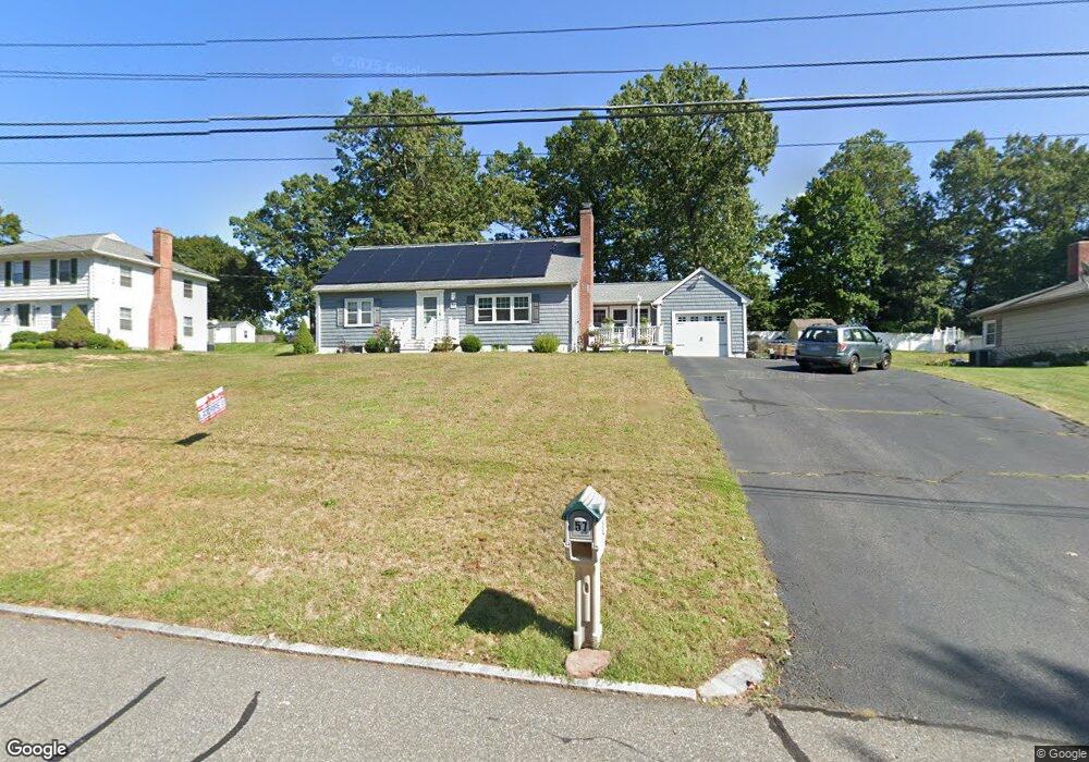
57 Newton Rd Springfield, MA 01118
East Forest Park NeighborhoodEstimated Value: $322,757 - $372,000
3
Beds
1
Bath
1,342
Sq Ft
$256/Sq Ft
Est. Value
About This Home
This home is located at 57 Newton Rd, Springfield, MA 01118 and is currently estimated at $343,439, approximately $255 per square foot. 57 Newton Rd is a home located in Hampden County with nearby schools including Frederick Harris Elementary School, M Marcus Kiley Middle, and Springfield High School of Science and Technology.
Ownership History
Date
Name
Owned For
Owner Type
Purchase Details
Closed on
Aug 27, 1999
Sold by
Macdonald Robert J and Gibson Kathleen A
Bought by
Dowd James and Dowd Pamela R
Current Estimated Value
Home Financials for this Owner
Home Financials are based on the most recent Mortgage that was taken out on this home.
Original Mortgage
$89,000
Interest Rate
7.53%
Mortgage Type
Purchase Money Mortgage
Create a Home Valuation Report for This Property
The Home Valuation Report is an in-depth analysis detailing your home's value as well as a comparison with similar homes in the area
Home Values in the Area
Average Home Value in this Area
Purchase History
| Date | Buyer | Sale Price | Title Company |
|---|---|---|---|
| Dowd James | $105,000 | -- |
Source: Public Records
Mortgage History
| Date | Status | Borrower | Loan Amount |
|---|---|---|---|
| Open | Dowd James | $41,300 | |
| Open | Dowd James | $136,000 | |
| Closed | Dowd James | $42,600 | |
| Closed | Dowd James | $89,000 |
Source: Public Records
Tax History
| Year | Tax Paid | Tax Assessment Tax Assessment Total Assessment is a certain percentage of the fair market value that is determined by local assessors to be the total taxable value of land and additions on the property. | Land | Improvement |
|---|---|---|---|---|
| 2025 | $4,789 | $305,400 | $41,700 | $263,700 |
| 2024 | $4,635 | $288,600 | $41,700 | $246,900 |
| 2023 | $4,469 | $262,100 | $43,300 | $218,800 |
| 2022 | $4,127 | $219,300 | $43,300 | $176,000 |
| 2021 | $3,980 | $210,600 | $39,400 | $171,200 |
| 2020 | $3,974 | $203,500 | $39,400 | $164,100 |
| 2019 | $3,977 | $202,100 | $39,400 | $162,700 |
| 2018 | $3,877 | $197,000 | $39,400 | $157,600 |
| 2017 | $3,256 | $165,600 | $39,400 | $126,200 |
| 2016 | $3,081 | $156,700 | $39,400 | $117,300 |
| 2015 | $3,061 | $155,600 | $39,400 | $116,200 |
Source: Public Records
Map
Nearby Homes
- 647 Plumtree Rd
- 101 Regal St
- 37 Chesterfield Ave
- 55 Old Farm Rd
- 120 Bridle Path Rd
- 509 Plumtree Rd
- 55 Allen St
- 384 Abbott St
- 81 W Crystal Brook Dr
- 744 Bradley Rd
- 86 Wildwood Ave
- 19 Manor Ct Unit 19
- 75 Gillette Cir
- 30 W Hill Rd
- 86 Talmadge Dr
- 24 Wands St
- 54 S Shore Dr
- 85 Talmadge Dr
- 17 Pebble Mill Rd
- 125 Manor Ct Unit 125
Your Personal Tour Guide
Ask me questions while you tour the home.