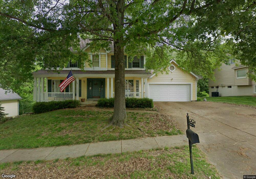
570 McBride Pointe Dr Ballwin, MO 63011
Estimated Value: $511,000 - $550,000
4
Beds
3
Baths
2,464
Sq Ft
$213/Sq Ft
Est. Value
About This Home
This home is located at 570 McBride Pointe Dr, Ballwin, MO 63011 and is currently estimated at $524,644, approximately $212 per square foot. 570 McBride Pointe Dr is a home located in St. Louis County with nearby schools including Babler Elementary School, Rockwood Valley Middle School, and Lafayette High School.
Ownership History
Date
Name
Owned For
Owner Type
Purchase Details
Closed on
Aug 21, 2000
Sold by
Lehmann Walter R and Ann Carol
Bought by
Lehmann Walter R
Current Estimated Value
Home Financials for this Owner
Home Financials are based on the most recent Mortgage that was taken out on this home.
Original Mortgage
$90,000
Interest Rate
7.87%
Create a Home Valuation Report for This Property
The Home Valuation Report is an in-depth analysis detailing your home's value as well as a comparison with similar homes in the area
Home Values in the Area
Average Home Value in this Area
Purchase History
| Date | Buyer | Sale Price | Title Company |
|---|---|---|---|
| Lehmann Walter R | -- | -- |
Source: Public Records
Mortgage History
| Date | Status | Borrower | Loan Amount |
|---|---|---|---|
| Closed | Lehmann Walter R | $90,000 |
Source: Public Records
Tax History
| Year | Tax Paid | Tax Assessment Tax Assessment Total Assessment is a certain percentage of the fair market value that is determined by local assessors to be the total taxable value of land and additions on the property. | Land | Improvement |
|---|---|---|---|---|
| 2025 | $5,208 | $74,390 | $23,750 | $50,640 |
| 2024 | $5,208 | $74,900 | $21,790 | $53,110 |
| 2023 | $5,208 | $74,900 | $21,790 | $53,110 |
| 2022 | $4,696 | $62,780 | $14,540 | $48,240 |
| 2021 | $4,662 | $62,780 | $14,540 | $48,240 |
| 2020 | $4,476 | $57,480 | $14,500 | $42,980 |
| 2019 | $4,494 | $57,480 | $14,500 | $42,980 |
| 2018 | $4,772 | $57,550 | $14,500 | $43,050 |
| 2017 | $4,658 | $57,550 | $14,500 | $43,050 |
| 2016 | $4,396 | $52,230 | $14,500 | $37,730 |
| 2015 | $4,306 | $52,230 | $14,500 | $37,730 |
| 2014 | $4,158 | $49,180 | $10,910 | $38,270 |
Source: Public Records
Map
Nearby Homes
- 1839 Sullivan Pointe Dr
- 16537 Clayton Rd
- 16597 Clayton Rd
- 1800 Wade Ct
- 1813 Wade Ct
- 16620 Clayton Rd
- 16404 Clayton Rd
- 2470 Indian Tree Cir
- 2525 Peppermill Ridge Dr
- 1525 Clayton Woods Ct
- 16641 Wycliffe Place Dr
- 1504 Englebrook Dr
- 2167 Wildwood Meadows Ct
- 220 Timber Meadow Dr
- 1640 Timber Hollow Dr
- 401 Thunderhead Canyon Dr
- 342 Clayton Trails Dr
- 2702 Hillcroft Dr
- 2209 Ridgley Woods Dr
- 16277 Autumn View Terrace Dr
- 574 McBride Pointe Dr
- 566 McBride Pointe Dr
- 562 McBride Pointe Dr
- 571 McBride Pointe Dr
- 567 McBride Pointe Dr
- 1856 Sullivan Pointe Dr
- 563 McBride Pointe Dr
- 1860 Sullivan Pointe Dr
- 1852 Sullivan Pointe Dr
- 579 McBride Pointe Dr
- 558 McBride Pointe Dr
- 621 Taylor Pointe Ct
- 559 McBride Pointe Dr
- 590 McBride Pointe Dr
- 583 McBride Pointe Dr
- 1927 Gastorf Pointe Ct
- 1921 Gastorf Pointe Ct
- 617 Taylor Pointe Ct
- 1915 Gastorf Pointe Ct
- 1855 Sullivan Pointe Dr
Your Personal Tour Guide
Ask me questions while you tour the home.