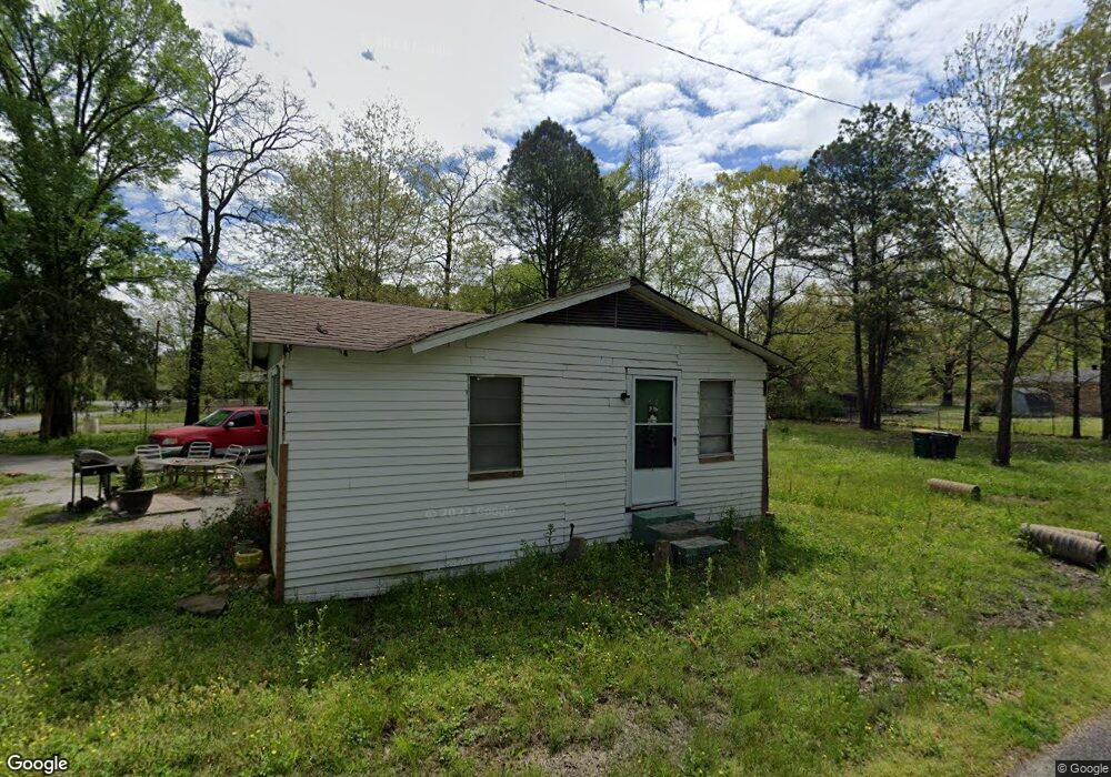
5701 Martin St Little Rock, AR 72206
Estimated Value: $34,000 - $166,000
--
Bed
1
Bath
968
Sq Ft
$82/Sq Ft
Est. Value
About This Home
This home is located at 5701 Martin St, Little Rock, AR 72206 and is currently estimated at $79,245, approximately $81 per square foot. 5701 Martin St is a home located in Pulaski County with nearby schools including Bates Elementary School and Mills University Studies High School.
Ownership History
Date
Name
Owned For
Owner Type
Purchase Details
Closed on
Jul 8, 2025
Sold by
Commissioner Of State Lands
Bought by
Rylwell Llc
Current Estimated Value
Purchase Details
Closed on
May 21, 2021
Sold by
Landnpulaski Llc
Bought by
Ryl Well Llc
Purchase Details
Closed on
May 2, 2017
Sold by
State Of Arkansas
Bought by
Landnpulaski Llc
Purchase Details
Closed on
Apr 12, 2007
Sold by
B&R Properties Llc
Bought by
Equity Trust Co
Purchase Details
Closed on
Aug 28, 2006
Sold by
Banning Jb
Bought by
B & R Properties Llc
Purchase Details
Closed on
Jan 4, 2006
Sold by
Banning Jb
Bought by
B & R Properties Llc
Purchase Details
Closed on
Nov 16, 2005
Sold by
Wilcox Mark
Bought by
Banning J B
Create a Home Valuation Report for This Property
The Home Valuation Report is an in-depth analysis detailing your home's value as well as a comparison with similar homes in the area
Home Values in the Area
Average Home Value in this Area
Purchase History
| Date | Buyer | Sale Price | Title Company |
|---|---|---|---|
| Rylwell Llc | $1,092 | None Listed On Document | |
| Ryl Well Llc | -- | None Available | |
| Landnpulaski Llc | $906 | None Available | |
| Equity Trust Co | -- | None Available | |
| B & R Properties Llc | -- | None Available | |
| B & R Properties Llc | -- | None Available | |
| Banning J B | $2,400 | -- |
Source: Public Records
Tax History Compared to Growth
Tax History
| Year | Tax Paid | Tax Assessment Tax Assessment Total Assessment is a certain percentage of the fair market value that is determined by local assessors to be the total taxable value of land and additions on the property. | Land | Improvement |
|---|---|---|---|---|
| 2025 | $224 | $4,007 | $800 | $3,207 |
| 2024 | $224 | $4,007 | $800 | $3,207 |
| 2023 | $224 | $4,007 | $800 | $3,207 |
| 2022 | $258 | $4,007 | $800 | $3,207 |
| 2021 | $156 | $2,190 | $400 | $1,790 |
| 2020 | $156 | $2,190 | $400 | $1,790 |
| 2019 | $156 | $2,190 | $400 | $1,790 |
| 2018 | $156 | $2,190 | $400 | $1,790 |
| 2017 | $122 | $2,190 | $400 | $1,790 |
| 2016 | $142 | $2,540 | $100 | $2,440 |
| 2015 | $142 | $2,540 | $100 | $2,440 |
| 2014 | $142 | $2,540 | $100 | $2,440 |
Source: Public Records
Map
Nearby Homes
- 14200 Arkansas 365
- 2312 Center St
- 14690 Hwy 365
- 0 Church St Unit 25028160
- 0 Holly St
- 16304 Arkansas 365
- 000 Lorance
- 2710 Marshfield Ct
- 5 Pine Thicket Ct
- 9425 Arkansas 365
- 9305 Highway 365 S
- 00 Pratt Rd
- 11505 Mona Ln
- 11601 Mona Ln
- 3629 Williams Rd
- 510 Binghamwood Rd
- 15105 Jenny Ln
- 00 Harper Rd
- 00 Highway 365 Hwy S
- 17825 Cullipher Ln