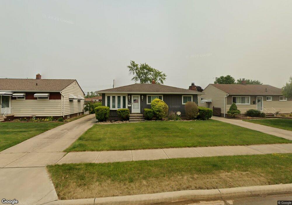
5721 Michael Dr Brookpark, OH 44142
Estimated Value: $210,000 - $230,000
3
Beds
1
Bath
944
Sq Ft
$231/Sq Ft
Est. Value
About This Home
This home is located at 5721 Michael Dr, Brookpark, OH 44142 and is currently estimated at $217,732, approximately $230 per square foot. 5721 Michael Dr is a home located in Cuyahoga County with nearby schools including Berea-Midpark Middle School, Berea-Midpark High School, and Huber Heights Preparatory Academy Parma Academy.
Ownership History
Date
Name
Owned For
Owner Type
Purchase Details
Closed on
Apr 12, 2001
Sold by
Kalas Kenneth K
Bought by
Fenn Linda K
Current Estimated Value
Home Financials for this Owner
Home Financials are based on the most recent Mortgage that was taken out on this home.
Original Mortgage
$100,000
Outstanding Balance
$36,946
Interest Rate
7.05%
Estimated Equity
$180,786
Purchase Details
Closed on
Jul 22, 1998
Sold by
Ogurchak Edward J and Ogurchak Genevieve M
Bought by
Kalas Kenneth K
Home Financials for this Owner
Home Financials are based on the most recent Mortgage that was taken out on this home.
Original Mortgage
$60,000
Interest Rate
7.03%
Purchase Details
Closed on
Jul 22, 1977
Sold by
Ogurchak Edward J and G M
Bought by
Ogurchak Edward J
Purchase Details
Closed on
Jan 1, 1975
Bought by
Ogurchak Edward J and G M
Create a Home Valuation Report for This Property
The Home Valuation Report is an in-depth analysis detailing your home's value as well as a comparison with similar homes in the area
Home Values in the Area
Average Home Value in this Area
Purchase History
| Date | Buyer | Sale Price | Title Company |
|---|---|---|---|
| Fenn Linda K | $133,000 | -- | |
| Kalas Kenneth K | $130,000 | Midland Title Security Inc | |
| Ogurchak Edward J | -- | -- | |
| Ogurchak Edward J | -- | -- |
Source: Public Records
Mortgage History
| Date | Status | Borrower | Loan Amount |
|---|---|---|---|
| Open | Fenn Linda K | $100,000 | |
| Previous Owner | Kalas Kenneth K | $60,000 |
Source: Public Records
Tax History Compared to Growth
Tax History
| Year | Tax Paid | Tax Assessment Tax Assessment Total Assessment is a certain percentage of the fair market value that is determined by local assessors to be the total taxable value of land and additions on the property. | Land | Improvement |
|---|---|---|---|---|
| 2024 | $2,816 | $55,825 | $10,640 | $45,185 |
| 2023 | $3,164 | $51,950 | $8,160 | $43,790 |
| 2022 | $3,142 | $51,940 | $8,155 | $43,785 |
| 2021 | $3,124 | $51,940 | $8,160 | $43,790 |
| 2020 | $2,817 | $41,230 | $6,480 | $34,760 |
| 2019 | $2,733 | $117,800 | $18,500 | $99,300 |
| 2018 | $1,361 | $41,230 | $6,480 | $34,760 |
| 2017 | $2,837 | $39,700 | $6,480 | $33,220 |
| 2016 | $2,813 | $39,700 | $6,480 | $33,220 |
| 2015 | $2,780 | $39,700 | $6,480 | $33,220 |
| 2014 | $2,780 | $41,800 | $6,830 | $34,970 |
Source: Public Records
Map
Nearby Homes
- 5677 Gateway Ln Unit E504
- 14417 Parkman Blvd
- 14344 Fayette Blvd
- 5348 W 147th St
- 5198 W 148th St
- 14055 Donald Dr
- 13489 Havendale Dr
- 13602 Holland Rd
- 6330 Michael Dr
- 15450 Holland Rd
- 13971 Park Dr
- 15665 Holland Rd
- 15800 Holland Rd
- 13931 Franklyn Blvd
- 16051 Holland Rd
- 6363 Lockhaven Dr
- 6378 Edgehurst Dr
- 13879 Zaremba Dr
- 6321 W 130th St
- 6274 Anita Dr
- 5727 Michael Dr
- 5713 Michael Dr
- 5735 Michael Dr
- 5707 Michael Dr
- 5724 Champaign Ave
- 5716 Champaign Ave
- 5732 Champaign Ave
- 5743 Michael Dr
- 5708 Champaign Ave
- 5726 Michael Dr
- 5718 Michael Dr
- 5734 Michael Dr
- 5710 Michael Dr
- 5751 Michael Dr
- 5746 Champaign Ave
- 5742 Michael Dr
- 5757 Michael Dr
- 5754 Champaign Ave
- 5750 Michael Dr
- 5721 Champaign Ave