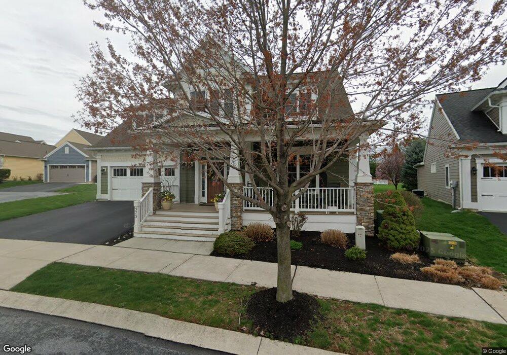
573 Constitution Dr Unit 13 Ephrata, PA 17522
Estimated Value: $574,657 - $666,000
2
Beds
2
Baths
2,014
Sq Ft
$302/Sq Ft
Est. Value
About This Home
This home is located at 573 Constitution Dr Unit 13, Ephrata, PA 17522 and is currently estimated at $607,914, approximately $301 per square foot. 573 Constitution Dr Unit 13 is a home located in Lancaster County with nearby schools including Ephrata Intermediate School, Clay Elementary School, and Ephrata Senior High School.
Ownership History
Date
Name
Owned For
Owner Type
Purchase Details
Closed on
Aug 22, 2016
Sold by
Rutt Jeffrey M and Rutt Cindia S
Bought by
Scanlon Thomas G and Scanlon Kathleen C
Current Estimated Value
Home Financials for this Owner
Home Financials are based on the most recent Mortgage that was taken out on this home.
Original Mortgage
$160,000
Outstanding Balance
$127,538
Interest Rate
3.45%
Mortgage Type
New Conventional
Estimated Equity
$480,376
Purchase Details
Closed on
May 27, 2010
Sold by
Lincoln Land Group Inc
Bought by
Rutt Jeffrey M and Rutt Cindia S
Home Financials for this Owner
Home Financials are based on the most recent Mortgage that was taken out on this home.
Original Mortgage
$313,000
Interest Rate
4.55%
Mortgage Type
New Conventional
Create a Home Valuation Report for This Property
The Home Valuation Report is an in-depth analysis detailing your home's value as well as a comparison with similar homes in the area
Home Values in the Area
Average Home Value in this Area
Purchase History
| Date | Buyer | Sale Price | Title Company |
|---|---|---|---|
| Scanlon Thomas G | $350,000 | Attorney | |
| Rutt Jeffrey M | $392,802 | None Available |
Source: Public Records
Mortgage History
| Date | Status | Borrower | Loan Amount |
|---|---|---|---|
| Open | Scanlon Thomas G | $160,000 | |
| Previous Owner | Rutt Jeffrey M | $313,000 |
Source: Public Records
Tax History Compared to Growth
Tax History
| Year | Tax Paid | Tax Assessment Tax Assessment Total Assessment is a certain percentage of the fair market value that is determined by local assessors to be the total taxable value of land and additions on the property. | Land | Improvement |
|---|---|---|---|---|
| 2025 | $7,750 | $338,400 | $87,300 | $251,100 |
| 2024 | $7,750 | $338,400 | $87,300 | $251,100 |
| 2023 | $7,550 | $338,400 | $87,300 | $251,100 |
| 2022 | $7,377 | $338,400 | $87,300 | $251,100 |
| 2021 | $7,218 | $338,400 | $87,300 | $251,100 |
| 2020 | $7,218 | $338,400 | $87,300 | $251,100 |
| 2019 | $7,117 | $338,400 | $87,300 | $251,100 |
| 2018 | $5,608 | $338,400 | $87,300 | $251,100 |
| 2017 | $7,253 | $284,600 | $42,200 | $242,400 |
| 2016 | $7,253 | $284,600 | $42,200 | $242,400 |
| 2015 | $1,433 | $284,600 | $42,200 | $242,400 |
| 2014 | $5,451 | $284,600 | $42,200 | $242,400 |
Source: Public Records
Map
Nearby Homes
- 308 Liberty St
- 124 Morning Dr
- 230 Meadowlark Dr
- 00 Morning Dr
- 131 Sunrise Ln
- Amberbrook Plan at Wyndale
- Northfield Plan at Wyndale
- Logan Plan at Wyndale
- Stonecroft Plan at Wyndale
- Darien Plan at Wyndale
- Atworth Plan at Wyndale
- Magnolia Plan at Wyndale
- Baker Plan at Wyndale
- Huntington Plan at Wyndale
- Westbrooke Plan at Wyndale
- Perry Plan at Wyndale
- Charlotte Plan at Wyndale
- Kingston Plan at Wyndale
- Brookfield Plan at Wyndale
- Silverbrooke Plan at Wyndale
- 573 Constitution Dr Unit 4
- 569 Constitution Dr
- 501 Nathan Dr
- 505 Nathan Dr
- 565 Constitution Dr
- 302 Declaration Ave
- 509 Nathan Dr
- 306 Declaration Ave
- 561 Constitution Dr
- 560 Constitution Dr
- 301 Declaration Ave
- 310 Declaration Ave
- 556 Constitution Dr
- 0 Harmony Dr Unit 10 1004574655
- 0 Harmony Dr Unit 153961
- 71 Gentleness Dr
- 75 Gentleness Drive L 14
- 67 Gentleness Dr
- 79 Gentleness Dr
- 305 Declaration Ave