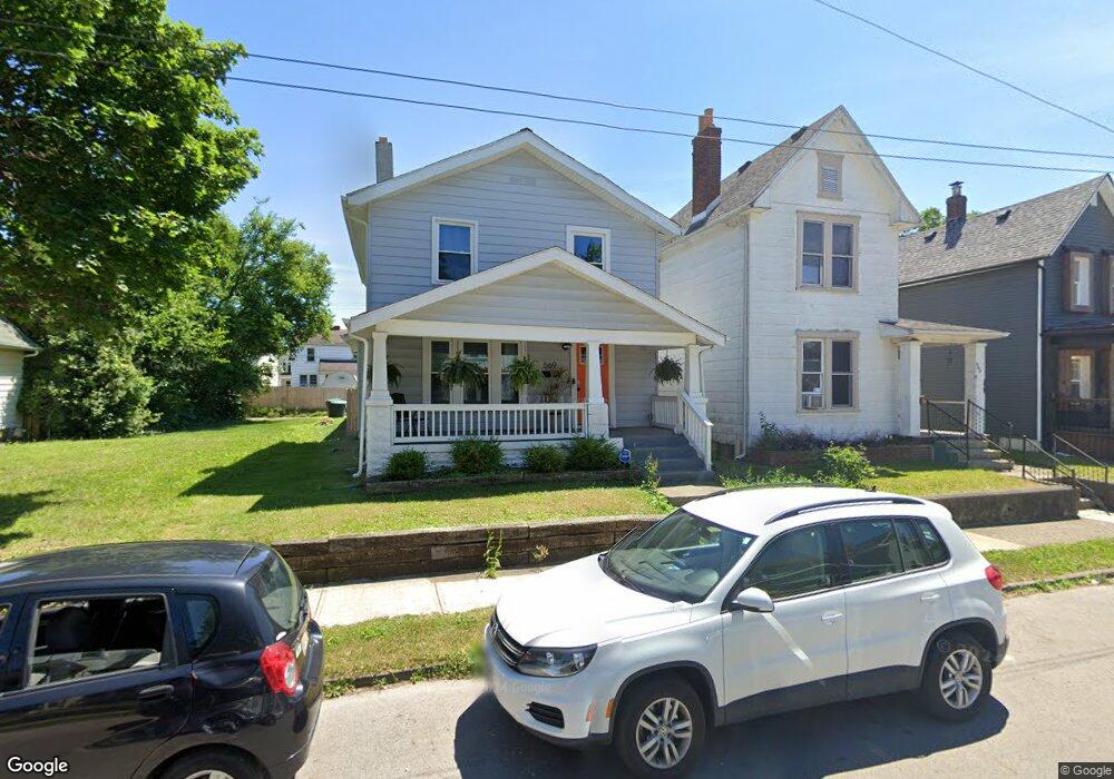
573 Stewart Ave Columbus, OH 43206
Karns Park NeighborhoodEstimated Value: $67,000
2
Beds
1
Bath
1,540
Sq Ft
$44/Sq Ft
Est. Value
About This Home
This home is located at 573 Stewart Ave, Columbus, OH 43206 and is currently priced at $67,000, approximately $43 per square foot. 573 Stewart Ave is a home located in Franklin County with nearby schools including Lincoln Park Elementary School, South High School, and South Columbus Preparatory Academy.
Ownership History
Date
Name
Owned For
Owner Type
Purchase Details
Closed on
Jun 18, 2019
Sold by
Central Ohio Community Improvement Corp
Bought by
City Of Columbus
Current Estimated Value
Purchase Details
Closed on
Apr 25, 2019
Sold by
Municipal Tax Property Llc
Bought by
Central Ohio Community Improvement Corp
Purchase Details
Closed on
Jun 4, 2008
Sold by
Burke Crystal L and Burke Crystal
Bought by
Burke Crystal L and The Crystal L Burke Living Trust
Purchase Details
Closed on
Jan 1, 2006
Sold by
Burke James F and Burke James
Bought by
Burke Crystal L
Purchase Details
Closed on
Apr 19, 1988
Bought by
Burke James
Create a Home Valuation Report for This Property
The Home Valuation Report is an in-depth analysis detailing your home's value as well as a comparison with similar homes in the area
Home Values in the Area
Average Home Value in this Area
Purchase History
| Date | Buyer | Sale Price | Title Company |
|---|---|---|---|
| City Of Columbus | -- | None Available | |
| Central Ohio Community Improvement Corp | -- | None Available | |
| Burke Crystal L | -- | Attorney | |
| Burke Crystal L | -- | None Available | |
| Burke James | $15,000 | -- |
Source: Public Records
Tax History Compared to Growth
Tax History
| Year | Tax Paid | Tax Assessment Tax Assessment Total Assessment is a certain percentage of the fair market value that is determined by local assessors to be the total taxable value of land and additions on the property. | Land | Improvement |
|---|---|---|---|---|
| 2024 | -- | $17,050 | $17,050 | -- |
| 2023 | -- | $17,045 | $17,045 | $0 |
| 2022 | $0 | $4,100 | $4,100 | $0 |
| 2021 | $0 | $4,100 | $4,100 | $0 |
| 2020 | $0 | $4,100 | $4,100 | $0 |
| 2019 | $16,583 | $3,150 | $3,150 | $0 |
| 2018 | $866 | $3,150 | $3,150 | $0 |
| 2017 | $7,922 | $3,150 | $3,150 | $0 |
| 2016 | $875 | $12,880 | $3,220 | $9,660 |
| 2015 | $998 | $12,880 | $3,220 | $9,660 |
| 2014 | $799 | $12,880 | $3,220 | $9,660 |
| 2013 | $490 | $13,580 | $3,395 | $10,185 |
Source: Public Records
Map
Nearby Homes
- 578 Stewart Ave
- 611 Siebert St
- 613 Siebert St
- 520 Cline St
- 531 E Deshler Ave
- 519-521 E Deshler Ave
- 1178 Wager St
- 1106-1116 Parsons Ave
- 524 Thurman Ave
- 1240 S 17th St
- 479 Siebert St
- 480 Siebert St
- 565 E Mithoff St
- 547 E Whittier St
- 515 E Mithoff St
- 650 E Mithoff St
- 596 E Whittier St
- 718 Reinhard Ave
- 1274 Wager St
- 693 Thurman Ave