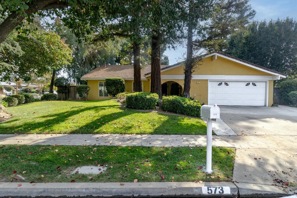


573 W Fremont Ave Fresno, CA 93704
Bullard NeighborhoodEstimated payment $3,117/month
Highlights
- In Ground Pool
- Mature Landscaping
- Fenced Yard
- 1 Fireplace
- Covered Patio or Porch
- Bathtub with Shower
About This Home
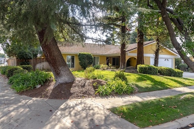
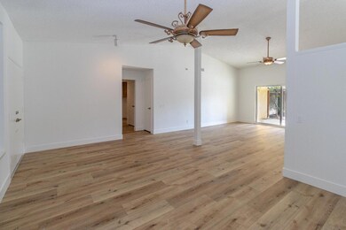
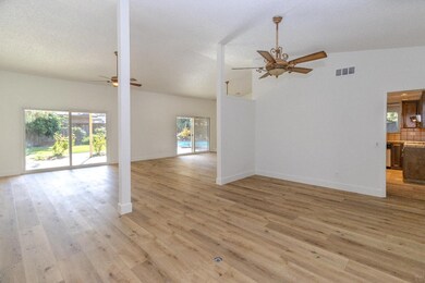
Stylish updates meet timeless charm in this beautifully renovated4-bedroom, 2-bath home on one of the largest lots in the neighborhood (approx. 12,000 sq. ft.), offering comfort, style, and plenty of space inside and out! Step into a generous living area with room for entertaining, complemented by additional space for dining. The home features all new LVP flooring throughout and fresh interior paint for a clean, modern feel. Both bathrooms have been tastefully remodeled with new cabinets, countertops, and faucets. Enjoy added comfort with an energy-saving whole house fan.
Enjoy the outdoors surrounded by mature landscaping, lush plants, and large shade trees. The sparkling pool is perfect for relaxing or entertaining.
Listing Agent
Michelle Dibuduo
Realty Concepts, Ltd. - Fresno License #01835519 Listed on: 11/05/2025
Home Details
Home Type
- Single Family
Year Built
- Built in 1978
Lot Details
- 0.28 Acre Lot
- Lot Dimensions are 100x120
- Fenced Yard
- Mature Landscaping
- Front and Back Yard Sprinklers
- Property is zoned RS4
Home Design
- Concrete Foundation
- Tile Roof
- Stucco
Interior Spaces
- 2,146 Sq Ft Home
- 1-Story Property
- Whole House Fan
- 1 Fireplace
- Laundry in Utility Room
Bedrooms and Bathrooms
- 4 Bedrooms
- 2 Bathrooms
- Bathtub with Shower
- Separate Shower
Outdoor Features
- In Ground Pool
- Covered Patio or Porch
Utilities
- Central Heating and Cooling System
Map
Home Values in the Area
Average Home Value in this Area
Tax History
| Year | Tax Paid | Tax Assessment Tax Assessment Total Assessment is a certain percentage of the fair market value that is determined by local assessors to be the total taxable value of land and additions on the property. | Land | Improvement |
|---|---|---|---|---|
| 2025 | $4,016 | $309,436 | $67,184 | $242,252 |
| 2023 | $3,863 | $297,422 | $64,576 | $232,846 |
| 2022 | $3,648 | $291,591 | $63,310 | $228,281 |
| 2021 | $3,546 | $285,874 | $62,069 | $223,805 |
| 2020 | $3,530 | $282,944 | $61,433 | $221,511 |
| 2019 | $3,393 | $277,397 | $60,229 | $217,168 |
| 2018 | $3,317 | $271,959 | $59,049 | $212,910 |
| 2017 | $3,259 | $266,628 | $57,892 | $208,736 |
| 2016 | $3,149 | $261,401 | $56,757 | $204,644 |
| 2015 | $3,100 | $257,476 | $55,905 | $201,571 |
| 2014 | $3,041 | $252,433 | $54,810 | $197,623 |
Property History
| Date | Event | Price | List to Sale | Price per Sq Ft |
|---|---|---|---|---|
| 11/17/2025 11/17/25 | Pending | -- | -- | -- |
| 11/05/2025 11/05/25 | For Sale | $529,000 | -- | $247 / Sq Ft |
Purchase History
| Date | Type | Sale Price | Title Company |
|---|---|---|---|
| Interfamily Deed Transfer | -- | None Available | |
| Interfamily Deed Transfer | -- | -- | |
| Interfamily Deed Transfer | -- | Fidelity National Title Co |
Mortgage History
| Date | Status | Loan Amount | Loan Type |
|---|---|---|---|
| Previous Owner | $113,500 | No Value Available |
Source: Fresno MLS
MLS Number: 639260
APN: 407-550-49S
Disclaimer: Certain information contained herein is derived from information provided by parties other than Homes.com. All information provided is deemed reliable, but is not guaranteed to be accurate and should be independently verified.
![]() IDX information is provided exclusively for personal, non-commercial use, and may not be used for any purpose other than to identify prospective properties consumers may be interested in purchasing. Information is deemed reliable but not guaranteed.
IDX information is provided exclusively for personal, non-commercial use, and may not be used for any purpose other than to identify prospective properties consumers may be interested in purchasing. Information is deemed reliable but not guaranteed.
- 6607 N Maroa Ave
- 744 W Palo Altp Ave
- 744 W Magill Ave
- 7013 N Maroa Ave
- 1 Palm Ave
- 491 W Fir Ave
- 355 W Sierra Ave Unit 106
- 6300 N Palm Ave Unit 105
- 6300 N Palm Ave Unit 109
- 221 W Herndon Ave Unit 120
- 221 W Herndon Ave Unit 87
- 221 W Herndon Ave Unit 59
- 221 W Herndon Ave Unit 49
- 221 W Herndon Ave Unit 27
- 221 W Herndon Ave Unit 130
- 221 W Herndon Ave Unit 50
- 221 W Herndon Ave Unit 192
- 375 W Fir Ave
- 6260 N Palm Ave Unit 111
- 1041 W Sierra Ave