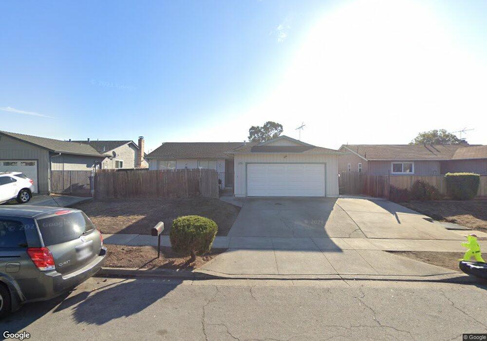
5736 Saint Paul Dr Newark, CA 94560
Estimated Value: $1,170,794 - $1,300,000
4
Beds
2
Baths
1,464
Sq Ft
$851/Sq Ft
Est. Value
About This Home
This home is located at 5736 Saint Paul Dr, Newark, CA 94560 and is currently estimated at $1,245,699, approximately $850 per square foot. 5736 Saint Paul Dr is a home located in Alameda County with nearby schools including Birch Grove Intermediate School, Newark Junior High School, and Newark Memorial High School.
Ownership History
Date
Name
Owned For
Owner Type
Purchase Details
Closed on
Nov 16, 2017
Sold by
Schuck Daniel W and Schuck Muriel
Bought by
Dranga Schuck Daniel Winfield and Dranga Schuck Muriel Anne
Current Estimated Value
Purchase Details
Closed on
Jun 25, 2002
Sold by
Schuck Daniel W and Schuck Muriel
Bought by
Schuck Daniel W and Schuck Muriel
Home Financials for this Owner
Home Financials are based on the most recent Mortgage that was taken out on this home.
Original Mortgage
$170,000
Interest Rate
6.78%
Create a Home Valuation Report for This Property
The Home Valuation Report is an in-depth analysis detailing your home's value as well as a comparison with similar homes in the area
Home Values in the Area
Average Home Value in this Area
Purchase History
| Date | Buyer | Sale Price | Title Company |
|---|---|---|---|
| Dranga Schuck Daniel Winfield | -- | None Available | |
| Schuck Daniel W | -- | First American Title |
Source: Public Records
Mortgage History
| Date | Status | Borrower | Loan Amount |
|---|---|---|---|
| Closed | Schuck Daniel W | $170,000 |
Source: Public Records
Tax History Compared to Growth
Tax History
| Year | Tax Paid | Tax Assessment Tax Assessment Total Assessment is a certain percentage of the fair market value that is determined by local assessors to be the total taxable value of land and additions on the property. | Land | Improvement |
|---|---|---|---|---|
| 2025 | $1,759 | $88,696 | $21,152 | $67,544 |
| 2024 | $1,759 | $86,956 | $20,737 | $66,219 |
| 2023 | $1,691 | $85,252 | $20,331 | $64,921 |
| 2022 | $1,641 | $83,580 | $19,932 | $63,648 |
| 2021 | $1,607 | $81,941 | $19,541 | $62,400 |
| 2020 | $1,503 | $81,101 | $19,341 | $61,760 |
| 2019 | $1,488 | $79,512 | $18,962 | $60,550 |
| 2018 | $1,459 | $77,952 | $18,590 | $59,362 |
| 2017 | $1,422 | $76,425 | $18,226 | $58,199 |
| 2016 | $1,390 | $74,925 | $17,868 | $57,057 |
| 2015 | $1,384 | $73,800 | $17,600 | $56,200 |
| 2014 | $1,340 | $72,355 | $17,255 | $55,100 |
Source: Public Records
Map
Nearby Homes
- 5669 Civic Terrace Ave
- 5859 Central Ave
- 6198 Civic Terrace Ave Unit A
- 5912 Mayhews Landing Rd
- 36931 Newark Blvd Unit E
- 6176 Thomas Ave
- 37088 Arden St
- 37659 Granville Dr
- 6245 Thornton Ave
- 6189 Thornton Ave Unit C
- 5268 Keeler Ct
- 6234 Zulmida Ave
- 6433 Thornton Ave
- 6257 Honeysuckle Dr
- 6065 Robertson Ave
- 36720 Charles St
- 36593 Leone St
- 6364 Noel Ave
- 5879 Caleb Ct
- 36686 Charles St
- 5722 Saint Paul Dr
- 5727 Saint Matthew Dr
- 5715 Saint Matthew Dr
- 5741 Saint Matthew Dr
- 5764 Saint Paul Dr
- 5708 Saint Paul Dr
- 5753 Saint Matthew Dr
- 5703 Saint Matthew Dr
- 5739 Saint Paul Dr
- 5723 Saint Paul Dr
- 5751 Saint Paul Dr
- 37183 Saint Matthew Dr
- 5772 Saint Paul Dr
- 5765 Saint Matthew Dr
- 5767 Saint Paul Dr
- 37165 Saint Matthew Dr
- 5784 Saint Paul Dr
- 5724 Civic Terrace Ave
- 5710 Civic Terrace Ave
- 5775 Saint Paul Dr