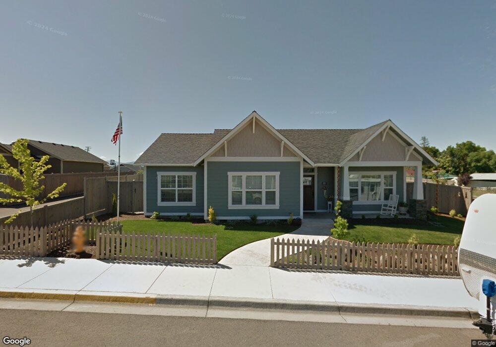
575 Barton Rd Unit Lt3 Eagle Point, OR 97524
Estimated Value: $400,337 - $439,000
3
Beds
2
Baths
1,586
Sq Ft
$260/Sq Ft
Est. Value
About This Home
This home is located at 575 Barton Rd Unit Lt3, Eagle Point, OR 97524 and is currently estimated at $412,584, approximately $260 per square foot. 575 Barton Rd Unit Lt3 is a home located in Jackson County with nearby schools including Eagle Rock Elementary School, Eagle Point Middle School, and White Mountain Middle School.
Ownership History
Date
Name
Owned For
Owner Type
Purchase Details
Closed on
Apr 15, 2022
Sold by
Breckenridge Property Fund 2016 Llc
Bought by
Gunther David Allen and Little Billie J
Current Estimated Value
Home Financials for this Owner
Home Financials are based on the most recent Mortgage that was taken out on this home.
Original Mortgage
$72,000
Outstanding Balance
$67,832
Interest Rate
5%
Mortgage Type
New Conventional
Estimated Equity
$344,752
Purchase Details
Closed on
Apr 14, 2022
Sold by
Breckenridge Property Fund 2016 Llc
Bought by
Gunther David Allen and Little Billie J
Home Financials for this Owner
Home Financials are based on the most recent Mortgage that was taken out on this home.
Original Mortgage
$72,000
Outstanding Balance
$67,832
Interest Rate
5%
Mortgage Type
New Conventional
Estimated Equity
$344,752
Purchase Details
Closed on
Jan 20, 2022
Sold by
Welhelm Calvin
Bought by
Breckenridge Property Fund 201
Purchase Details
Closed on
Sep 15, 2016
Sold by
Loyd Jan M and Loyd Todd M
Bought by
Pfau Elaine B
Home Financials for this Owner
Home Financials are based on the most recent Mortgage that was taken out on this home.
Original Mortgage
$394,500
Interest Rate
3.45%
Mortgage Type
Reverse Mortgage Home Equity Conversion Mortgage
Purchase Details
Closed on
Apr 27, 2016
Sold by
Padilla Yvonne A and Gonzalez Leonardo J
Bought by
Welhelm Calvin
Purchase Details
Closed on
Sep 3, 2009
Sold by
Sullivan Michael E and Sullivan Sandra M
Bought by
Padilla Yvonne A and Gonzalez Leonardo J
Home Financials for this Owner
Home Financials are based on the most recent Mortgage that was taken out on this home.
Original Mortgage
$214,285
Interest Rate
5.19%
Mortgage Type
New Conventional
Purchase Details
Closed on
Feb 25, 2009
Sold by
Future Concepts Llc
Bought by
Sullivan Michael E and Sullivan Sandra M
Home Financials for this Owner
Home Financials are based on the most recent Mortgage that was taken out on this home.
Original Mortgage
$146,555
Interest Rate
4.91%
Mortgage Type
Commercial
Create a Home Valuation Report for This Property
The Home Valuation Report is an in-depth analysis detailing your home's value as well as a comparison with similar homes in the area
Home Values in the Area
Average Home Value in this Area
Purchase History
| Date | Buyer | Sale Price | Title Company |
|---|---|---|---|
| Gunther David Allen | $405,000 | Ticor Title | |
| Gunther David Allen | $405,000 | Ticor Title | |
| Breckenridge Property Fund 201 | $305,000 | Ticor Title | |
| Pfau Elaine B | $263,000 | Ticor Title Company Of Or | |
| Welhelm Calvin | $259,900 | Ticor Title Company Of Or | |
| Padilla Yvonne A | $210,000 | First American Title | |
| Sullivan Michael E | $72,500 | First American Title |
Source: Public Records
Mortgage History
| Date | Status | Borrower | Loan Amount |
|---|---|---|---|
| Open | Gunther David Allen | $72,000 | |
| Closed | Gunther David Allen | $72,000 | |
| Previous Owner | Pfau Elaine B | $394,500 | |
| Previous Owner | Padilla Yvonne A | $214,285 | |
| Previous Owner | Sullivan Michael E | $146,555 |
Source: Public Records
Tax History
| Year | Tax Paid | Tax Assessment Tax Assessment Total Assessment is a certain percentage of the fair market value that is determined by local assessors to be the total taxable value of land and additions on the property. | Land | Improvement |
|---|---|---|---|---|
| 2026 | $2,770 | $203,540 | -- | -- |
| 2025 | $2,704 | $197,620 | $83,580 | $114,040 |
| 2024 | $2,704 | $191,870 | $81,150 | $110,720 |
| 2023 | $2,613 | $186,290 | $78,790 | $107,500 |
| 2022 | $2,541 | $186,290 | $78,790 | $107,500 |
| 2021 | $2,466 | $180,870 | $76,490 | $104,380 |
| 2020 | $2,620 | $175,610 | $74,260 | $101,350 |
| 2019 | $2,580 | $165,540 | $70,010 | $95,530 |
| 2018 | $2,531 | $160,720 | $67,970 | $92,750 |
| 2017 | $2,469 | $160,720 | $67,970 | $92,750 |
| 2016 | $2,421 | $151,500 | $64,070 | $87,430 |
| 2015 | $2,341 | $151,500 | $64,070 | $87,430 |
| 2014 | $2,274 | $142,810 | $60,390 | $82,420 |
Source: Public Records
Map
Nearby Homes
- 584 Barton Rd
- 945 Win Way
- 700 Nottingham Terrace
- 208 Northview Dr Unit 1B
- 712 Nottingham Terrace
- 190 Barton Rd
- 1017 Havenwood Dr
- 417 E Rolling Hills Dr
- 110 Linton Way
- 1023 Highlands Dr
- 925 Sellwood Dr
- 912 Stonewater Dr
- 911 Stonewater Dr
- 917 Stonewater Dr
- 426 Westminster Dr
- 438 Westminster Dr
- 407 N Deanjou Ave
- 403 N Deanjou Ave
- 460 Montclair Way
- 250 Tierra Cir
- 575 Barton Rd
- 569 Barton Rd Unit Lt2
- 569 Barton Rd
- 581 Barton Rd Unit Lt4
- 581 Barton Rd
- 563 Barton Rd Unit Lt1
- 563 Barton Rd
- 587 Barton Rd
- 587 Barton Rd Unit Lt5
- 663 Sheffield Dr Unit Lt7
- 663 Sheffield Dr
- 669 Sheffield Dr Unit Lt8
- 669 Sheffield Dr
- 657 Sheffield Dr
- 657 Sheffield Dr Unit Lt6
- 675 Sheffield Dr Unit Lt9
- 675 Sheffield Dr
- 693 Sheffield Dr
- 375 Barton Rd
- 578 Barton Rd
Your Personal Tour Guide
Ask me questions while you tour the home.