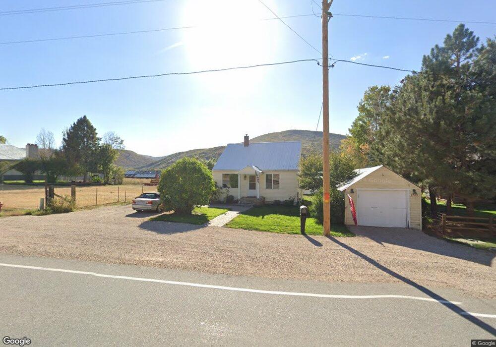
5769 Utah 32 Peoa, UT 84061
Kamas Valley NeighborhoodEstimated Value: $474,059 - $530,000
2
Beds
1
Bath
1,456
Sq Ft
$343/Sq Ft
Est. Value
About This Home
This home is located at 5769 Utah 32, Peoa, UT 84061 and is currently estimated at $499,020, approximately $342 per square foot. 5769 Utah 32 is a home located in Summit County with nearby schools including South Summit Elementary School and South Summit High School.
Ownership History
Date
Name
Owned For
Owner Type
Purchase Details
Closed on
Aug 29, 2019
Sold by
Meredith Neal
Bought by
Winter Farms Llc
Current Estimated Value
Purchase Details
Closed on
Feb 20, 2015
Sold by
Zimmerman Teresa M and The James H Murnin Trust
Bought by
Meredith Neal
Home Financials for this Owner
Home Financials are based on the most recent Mortgage that was taken out on this home.
Original Mortgage
$152,295
Interest Rate
3.57%
Mortgage Type
New Conventional
Purchase Details
Closed on
Jun 13, 2006
Sold by
Larson Nels Olaf and Larson Diana M
Bought by
Zimmerman Teresa M
Create a Home Valuation Report for This Property
The Home Valuation Report is an in-depth analysis detailing your home's value as well as a comparison with similar homes in the area
Home Values in the Area
Average Home Value in this Area
Purchase History
| Date | Buyer | Sale Price | Title Company |
|---|---|---|---|
| Winter Farms Llc | -- | Real Advantage Ttl Ins Agcy | |
| Meredith Neal | -- | North American Title | |
| Zimmerman Teresa M | -- | Inwest Title Services Inc |
Source: Public Records
Mortgage History
| Date | Status | Borrower | Loan Amount |
|---|---|---|---|
| Previous Owner | Meredith Neal | $152,295 |
Source: Public Records
Tax History Compared to Growth
Tax History
| Year | Tax Paid | Tax Assessment Tax Assessment Total Assessment is a certain percentage of the fair market value that is determined by local assessors to be the total taxable value of land and additions on the property. | Land | Improvement |
|---|---|---|---|---|
| 2024 | $1,081 | $207,052 | $93,500 | $113,552 |
| 2023 | $1,081 | $207,052 | $93,500 | $113,552 |
| 2022 | $885 | $148,078 | $66,000 | $82,078 |
| 2021 | $583 | $79,051 | $25,300 | $53,751 |
| 2020 | $525 | $66,461 | $25,300 | $41,161 |
| 2019 | $581 | $66,461 | $25,300 | $41,161 |
| 2018 | $461 | $55,216 | $20,350 | $34,866 |
| 2017 | $422 | $53,118 | $20,350 | $32,768 |
| 2016 | $400 | $47,309 | $14,541 | $32,768 |
| 2015 | $409 | $47,309 | $0 | $0 |
| 2013 | $422 | $45,210 | $0 | $0 |
Source: Public Records
Map
Nearby Homes
- 5685 N State Road 32
- 5661 N State Road 32
- 2640 W State Road 32
- 1788 W Farmhouse Flats Rd
- 1788 W Farmhouse Flats Rd Unit 5
- 2575 W State Road 32
- 6117 N Rocky Ridge Rd
- 6117 Rocky Ridge Rd
- 7795 Browns Canyon Rd
- 6950 N River Valley Dr
- 7050 N River Valley Dr
- 7795 Browns Rd
- 6325 N Elk Ridge Rd Unit 5
- 5167 Rodeo Cir
- 5167 Rodeo Cir Unit 6
- 5402 N 750 W
- 919 River Haven Rd Unit 114
- 972 River Haven Rd Unit 101
- 949 River Haven Rd S Unit 115
- 1400 E Weber Wild Rd
- 5769 N State Road 32
- 5769 N State Road 32 Unit 32
- 5800 N State Road 32
- 5790 N State Road 32
- 5736 N State Road 32
- 5742 N State Rd
- 5736 N State Rd
- 5750 N State Road 32
- 5830 N State Road 32
- 5685 Utah 32
- 5619 N Highway 189
- 5674 N State Road 32
- 5739 N State Road 32
- 5661 N State Road 32 Unit 32
- 5880 N State Road 32
- 5660 Utah 32
- 5660 N State Road 32
- 5651 N State Road 32
- 5651 Utah 32
- 5651 N State Route