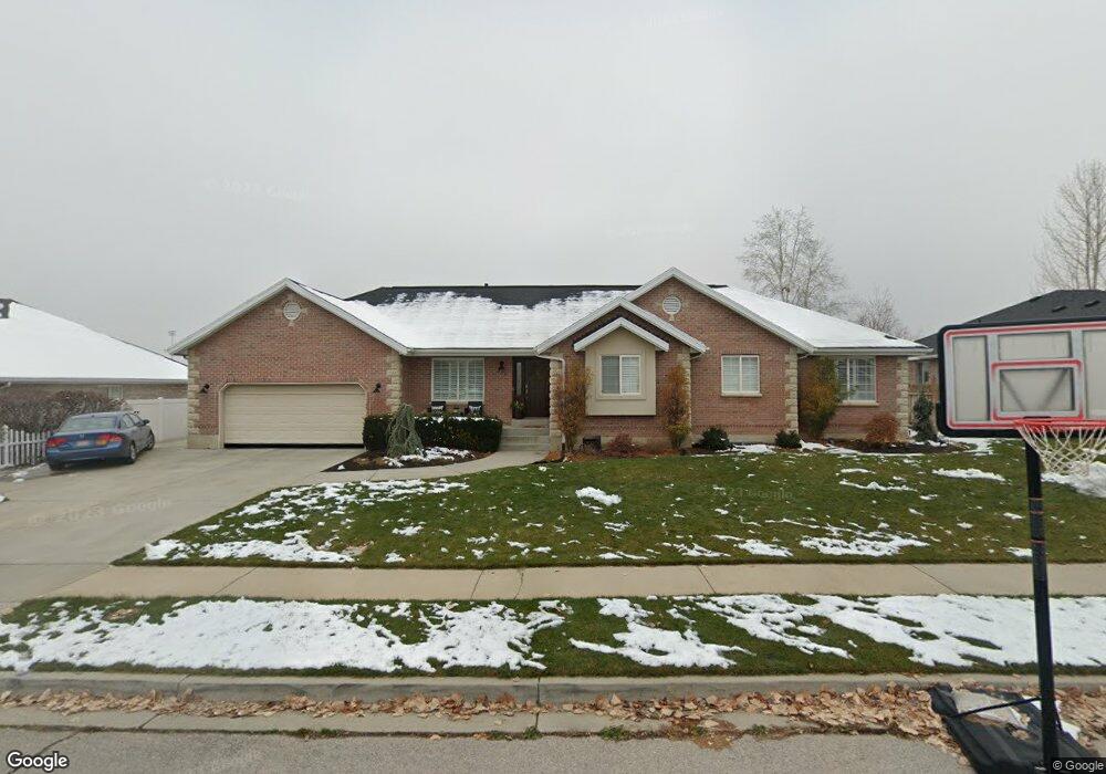
577 N 800 E American Fork, UT 84003
Estimated Value: $580,000 - $703,615
3
Beds
4
Baths
1,931
Sq Ft
$340/Sq Ft
Est. Value
About This Home
This home is located at 577 N 800 E, American Fork, UT 84003 and is currently estimated at $656,538, approximately $339 per square foot. 577 N 800 E is a home located in Utah County with nearby schools including Barratt Elementary School, American Fork Junior High School, and American Fork High School.
Ownership History
Date
Name
Owned For
Owner Type
Purchase Details
Closed on
Aug 15, 2019
Sold by
Caroll Curtis R and Carroll Annette
Bought by
Blackhurst David Reese and Blackhurst Ashley
Current Estimated Value
Home Financials for this Owner
Home Financials are based on the most recent Mortgage that was taken out on this home.
Original Mortgage
$360,000
Outstanding Balance
$315,293
Interest Rate
3.7%
Estimated Equity
$341,245
Purchase Details
Closed on
Mar 7, 2003
Sold by
Carroll Curtis and Carroll Annette
Bought by
Carroll Curtis R and Carroll Annette
Home Financials for this Owner
Home Financials are based on the most recent Mortgage that was taken out on this home.
Original Mortgage
$172,000
Interest Rate
5.83%
Create a Home Valuation Report for This Property
The Home Valuation Report is an in-depth analysis detailing your home's value as well as a comparison with similar homes in the area
Home Values in the Area
Average Home Value in this Area
Purchase History
| Date | Buyer | Sale Price | Title Company |
|---|---|---|---|
| Blackhurst David Reese | -- | Inwest Title Orem | |
| Carroll Curtis R | -- | Precision Title Company |
Source: Public Records
Mortgage History
| Date | Status | Borrower | Loan Amount |
|---|---|---|---|
| Open | Blackhurst David Reese | $360,000 | |
| Previous Owner | Carroll Curtis R | $172,000 |
Source: Public Records
Tax History
| Year | Tax Paid | Tax Assessment Tax Assessment Total Assessment is a certain percentage of the fair market value that is determined by local assessors to be the total taxable value of land and additions on the property. | Land | Improvement |
|---|---|---|---|---|
| 2025 | $3,128 | $366,960 | -- | -- |
| 2024 | $3,128 | $347,600 | $0 | $0 |
| 2023 | $2,915 | $343,365 | $0 | $0 |
| 2022 | $2,754 | $320,210 | $0 | $0 |
| 2021 | $2,423 | $439,900 | $183,200 | $256,700 |
| 2020 | $2,351 | $414,100 | $169,600 | $244,500 |
| 2019 | $2,188 | $398,600 | $162,400 | $236,200 |
| 2018 | $2,081 | $362,500 | $126,300 | $236,200 |
| 2017 | $2,121 | $199,375 | $0 | $0 |
| 2016 | $2,224 | $194,260 | $0 | $0 |
| 2015 | $2,128 | $176,330 | $0 | $0 |
| 2014 | $1,962 | $160,435 | $0 | $0 |
Source: Public Records
Map
Nearby Homes
- 837 E 475 N
- 474 N 850 E
- 912 E Ellens St Unit 1
- 462 N 950 E Unit 5
- 410 N 600 E
- 322 N 900 E
- 474 E 580 N
- 1121 E 580 N
- 266 N 500 E
- 198 N 600 E
- 261 N 500 E
- 1045 N 930 E Unit 58
- 649 N 1280 E
- 610 N 300 E
- 1058 N 930 E Unit 64
- 1089 N 950 E
- 2421 Renaissance Ct
- 16 N 700 E Unit 21
- 22 S 700 East St
- 80 N 400 E Unit G-2
Your Personal Tour Guide
Ask me questions while you tour the home.