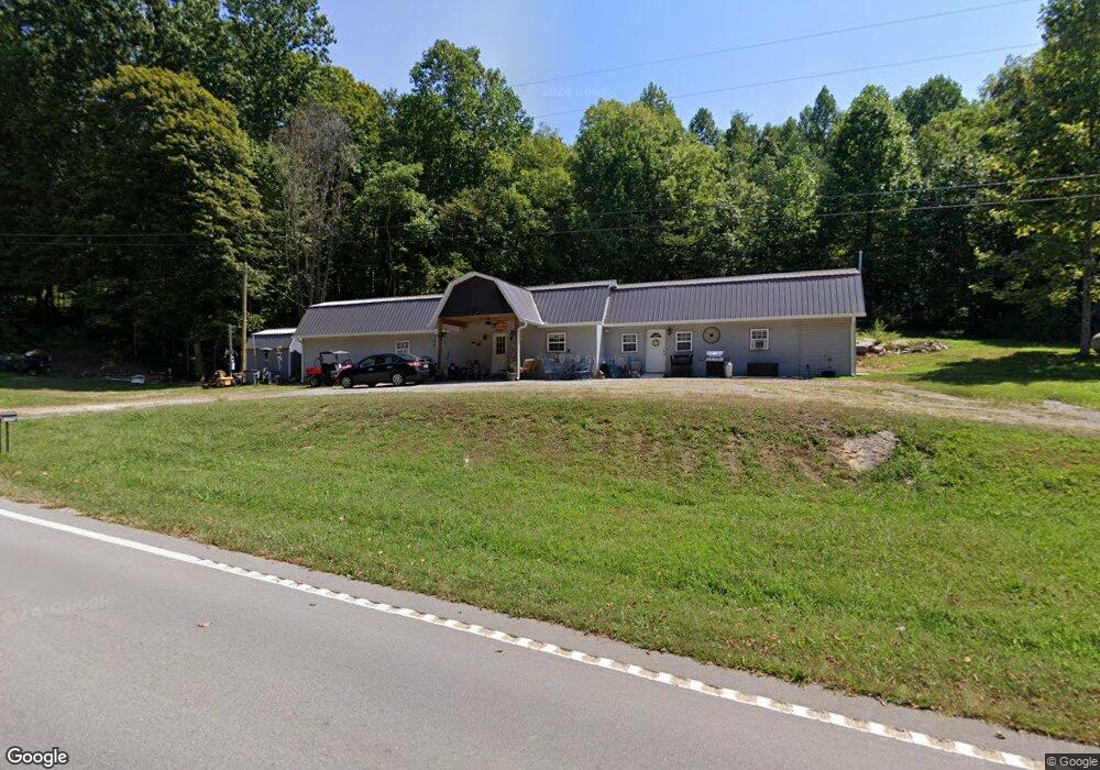
5770 Jamestown Hwy Alpine, TN 38543
Estimated Value: $189,303 - $347,000
--
Bed
--
Bath
1,300
Sq Ft
$207/Sq Ft
Est. Value
About This Home
This home is located at 5770 Jamestown Hwy, Alpine, TN 38543 and is currently estimated at $268,826, approximately $206 per square foot. 5770 Jamestown Hwy is a home located in Overton County with nearby schools including Pickett County Elementary School and Pickett County High School.
Ownership History
Date
Name
Owned For
Owner Type
Purchase Details
Closed on
Sep 24, 2021
Sold by
Craig Clyde and Craig Vickie
Bought by
Smith Michael J and Smith Michelle Faith
Current Estimated Value
Purchase Details
Closed on
Mar 11, 2003
Bought by
Craig Clyde and Craig Vickie
Purchase Details
Closed on
Aug 22, 2002
Bought by
Suggs Ronnie and Suggs Kelli
Purchase Details
Closed on
Sep 17, 1996
Bought by
Linder Jim
Create a Home Valuation Report for This Property
The Home Valuation Report is an in-depth analysis detailing your home's value as well as a comparison with similar homes in the area
Home Values in the Area
Average Home Value in this Area
Purchase History
| Date | Buyer | Sale Price | Title Company |
|---|---|---|---|
| Smith Michael J | $20,000 | None Available | |
| Smith Michael J | $20,000 | None Listed On Document | |
| Craig Clyde | $50,700 | -- | |
| Suggs Ronnie | $42,500 | -- | |
| Linder Jim | $35,000 | -- |
Source: Public Records
Tax History Compared to Growth
Tax History
| Year | Tax Paid | Tax Assessment Tax Assessment Total Assessment is a certain percentage of the fair market value that is determined by local assessors to be the total taxable value of land and additions on the property. | Land | Improvement |
|---|---|---|---|---|
| 2025 | $687 | $40,200 | $0 | $0 |
| 2024 | $687 | $40,200 | $4,925 | $35,275 |
| 2023 | $276 | $40,200 | $4,925 | $35,275 |
| 2022 | $92 | $3,800 | $3,800 | $0 |
| 2021 | $92 | $3,800 | $3,800 | $0 |
| 2020 | $92 | $3,800 | $3,800 | $0 |
| 2019 | $93 | $3,800 | $3,800 | $0 |
| 2018 | $65 | $3,800 | $3,800 | $0 |
| 2017 | $63 | $3,350 | $3,350 | $0 |
| 2016 | $63 | $3,350 | $3,350 | $0 |
| 2015 | $63 | $3,350 | $0 | $0 |
| 2014 | $63 | $3,350 | $0 | $0 |
Source: Public Records
Map
Nearby Homes
- 37 Lot 37 Milky Way
- 0 Lot 55 Milky Way
- 2021 Milky Way
- 0 Milky Way Rd Unit RTC2996177
- 5735 E East Port Rd
- 0 Bolestown Loop
- 0 Bolestown Loop
- 00 Bolestown Loop
- 0 Cliff Edge Rd
- Lot Cliff Edge Rd
- 1100 Eastport Dock Rd
- 0 Jamestown Hwy Unit 11586513
- 770 Eastport Dock Rd
- 221 Cedar Grove Ln
- 464 Wilder Hwy (76 Ac)
- 1255 Winningham Rd
- 43.36 ac Winningham Rd
- 464 Wilder Hwy 76 Ac
- 464 Wilder Hwy 25 Ac
- 464 Wilder Hwy Unit 76 Ac
- 5770 Jamestown Hwy
- 5770 Jamestown Hwy
- 5835 Jamestown Hwy
- 5835 Jamestown Hwy Unit 5835
- 135 AC Jamestown Hwy
- 5065 Cooper Rd
- 5700 Jamestown Hwy Unit 5200
- 5700 Jamestown Hwy
- 54.92 AC Garfield Whited Rd
- 5869 Jamestown Hwy
- 5655 Jamestown Hwy Unit 5655
- 5005 Eastport Rd
- 5920 Jamestown Hwy
- 726 King Loop
- 5597 Jamestown Hwy
- 5009 Eastport Rd
- 715 King Loop
- 790 King Loop
- 760 King Loop
- 5139 Eastport Rd