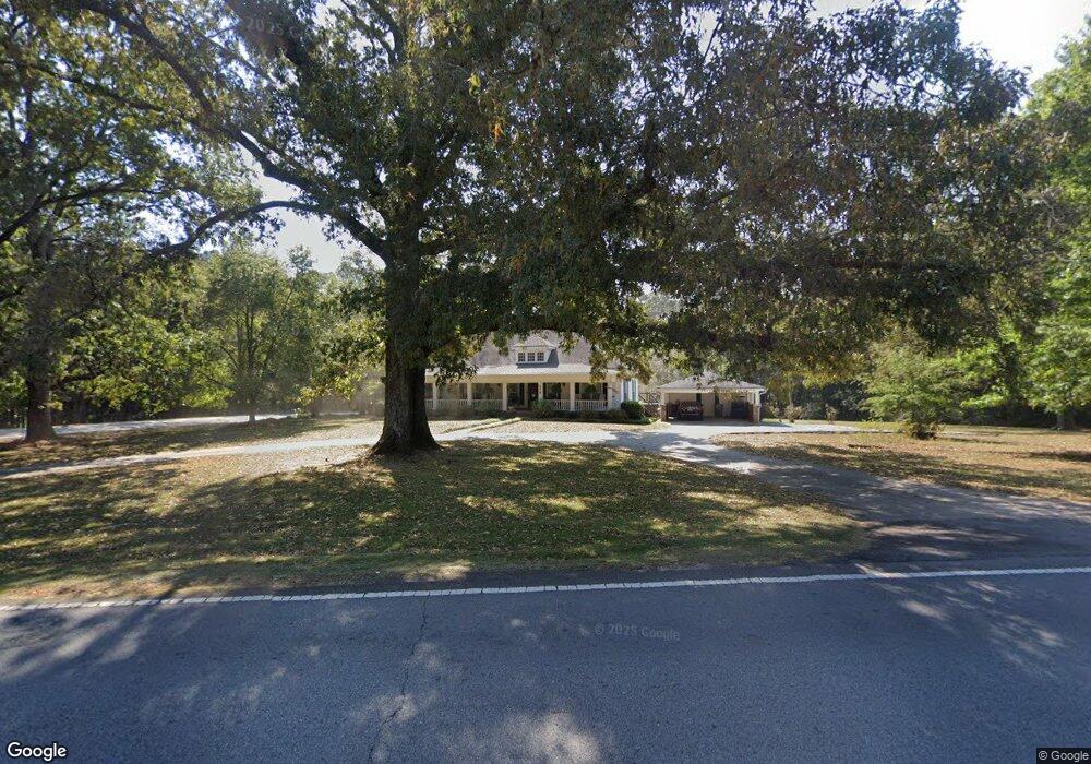
578 Tyus Carrollton Rd Carrollton, GA 30117
Estimated Value: $343,514 - $400,000
3
Beds
2
Baths
2,422
Sq Ft
$153/Sq Ft
Est. Value
About This Home
This home is located at 578 Tyus Carrollton Rd, Carrollton, GA 30117 and is currently estimated at $370,879, approximately $153 per square foot. 578 Tyus Carrollton Rd is a home located in Carroll County with nearby schools including Central Elementary School, Central Middle School, and Central High School.
Ownership History
Date
Name
Owned For
Owner Type
Purchase Details
Closed on
Oct 22, 1997
Sold by
Dye James and Dye Marth
Bought by
Grisham William B
Current Estimated Value
Purchase Details
Closed on
Jul 23, 1996
Sold by
Woodall Roy L and Woodall Cind
Bought by
Dye James and Dye Marth
Purchase Details
Closed on
Sep 12, 1995
Sold by
Woodall Roy
Bought by
Woodall Roy L and Woodall Cind
Purchase Details
Closed on
Aug 4, 1995
Sold by
Lovvorn Reba
Bought by
Woodall Roy
Purchase Details
Closed on
Mar 25, 1992
Bought by
Lovvorn Reba
Create a Home Valuation Report for This Property
The Home Valuation Report is an in-depth analysis detailing your home's value as well as a comparison with similar homes in the area
Home Values in the Area
Average Home Value in this Area
Purchase History
| Date | Buyer | Sale Price | Title Company |
|---|---|---|---|
| Grisham William B | $120,000 | -- | |
| Dye James | $120,000 | -- | |
| Woodall Roy L | -- | -- | |
| Woodall Roy | $95,000 | -- | |
| Lovvorn Reba | -- | -- |
Source: Public Records
Tax History Compared to Growth
Tax History
| Year | Tax Paid | Tax Assessment Tax Assessment Total Assessment is a certain percentage of the fair market value that is determined by local assessors to be the total taxable value of land and additions on the property. | Land | Improvement |
|---|---|---|---|---|
| 2024 | $2,498 | $139,039 | $11,493 | $127,546 |
| 2023 | $2,498 | $125,349 | $9,195 | $116,154 |
| 2022 | $2,029 | $99,359 | $6,130 | $93,229 |
| 2021 | $1,823 | $85,077 | $4,904 | $80,173 |
| 2020 | $1,679 | $77,033 | $4,458 | $72,575 |
| 2019 | $1,571 | $70,479 | $4,458 | $66,021 |
| 2018 | $1,462 | $63,410 | $4,166 | $59,244 |
| 2017 | $1,466 | $63,410 | $4,166 | $59,244 |
| 2016 | $1,304 | $57,219 | $4,166 | $53,053 |
| 2015 | $1,158 | $45,389 | $5,416 | $39,974 |
| 2014 | $1,163 | $45,390 | $5,416 | $39,974 |
Source: Public Records
Map
Nearby Homes
- 399 Old Camp Church Rd
- 0 Bonner Rd Unit 10635754
- 20 Camp Ct
- 345 Piney Grove Rd
- 95 Camp Ln
- 105 Woodbine Dr
- The Coleman Plan at Summerfield Place
- The Pearson Plan at Summerfield Place
- The Piedmont Plan at Summerfield Place
- The Harrington Plan at Summerfield Place
- The McGinnis Plan at Summerfield Place
- The Telfair Plan at Summerfield Place
- 21 Crabapple Place
- 115 Greenwood Ln
- 40 Red Holly Gap
- 0 Buffalo Creek Rd Unit 10624169
- 533 Buffalo Creek Rd
- 295 Timber Ridge Trail
- 394 Maple View Dr
- 390 Maple View Dr
- 602 Tyus Carrollton Rd
- 597 Tyus Carrollton Rd
- 530 Tyus Carrollton Rd
- 657 Tyus Carrollton Rd
- 501 Old Camp Church Rd Unit B
- 501 Old Camp Church Rd
- 520 Tyus Carrollton Rd
- 505 Old Camp Church Rd
- 25 Boulder Dr
- 632 Tyus Carrollton Rd
- 531 Tyus Carrollton Rd
- 366 Old Camp Church Rd
- 37 Boulder Dr
- 627 Tyus Carrollton Rd
- 653 Tyus Carrollton Rd
- 0 Boulder Dr Unit 3202002
- 0 Boulder Dr Unit 7512270
- 525 Old Camp Church Rd
- 654 Tyus Carrollton Rd
- 526 Old Camp Church Rd