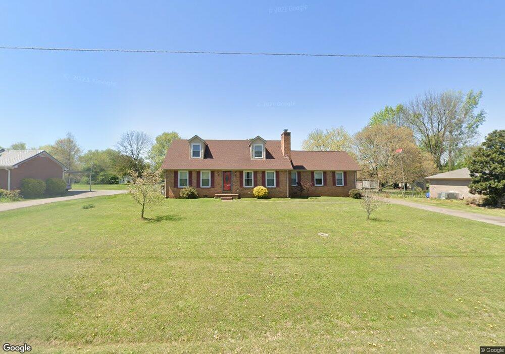
579 Deerfield Dr Murfreesboro, TN 37129
Estimated Value: $407,762 - $434,000
Studio
3
Baths
2,176
Sq Ft
$194/Sq Ft
Est. Value
About This Home
This home is located at 579 Deerfield Dr, Murfreesboro, TN 37129 and is currently estimated at $422,941, approximately $194 per square foot. 579 Deerfield Dr is a home located in Rutherford County with nearby schools including Blackman Elementary School, Blackman Middle School, and Blackman High School.
Ownership History
Date
Name
Owned For
Owner Type
Purchase Details
Closed on
May 30, 2003
Sold by
Hajjafar and April
Bought by
Simpson David E and Simpson Carol
Current Estimated Value
Home Financials for this Owner
Home Financials are based on the most recent Mortgage that was taken out on this home.
Original Mortgage
$122,815
Outstanding Balance
$53,838
Interest Rate
5.79%
Estimated Equity
$369,103
Create a Home Valuation Report for This Property
The Home Valuation Report is an in-depth analysis detailing your home's value as well as a comparison with similar homes in the area
Home Values in the Area
Average Home Value in this Area
Purchase History
| Date | Buyer | Sale Price | Title Company |
|---|---|---|---|
| Simpson David E | $133,500 | -- |
Source: Public Records
Mortgage History
| Date | Status | Borrower | Loan Amount |
|---|---|---|---|
| Open | Simpson David E | $122,815 |
Source: Public Records
Tax History
| Year | Tax Paid | Tax Assessment Tax Assessment Total Assessment is a certain percentage of the fair market value that is determined by local assessors to be the total taxable value of land and additions on the property. | Land | Improvement |
|---|---|---|---|---|
| 2025 | $1,588 | $85,075 | $13,750 | $71,325 |
| 2024 | $1,596 | $85,075 | $13,750 | $71,325 |
| 2023 | $1,596 | $85,075 | $13,750 | $71,325 |
| 2022 | $1,375 | $85,075 | $13,750 | $71,325 |
| 2021 | $1,329 | $59,900 | $9,250 | $50,650 |
| 2020 | $1,329 | $59,900 | $9,250 | $50,650 |
| 2019 | $1,329 | $59,900 | $9,250 | $50,650 |
| 2018 | $1,258 | $59,900 | $0 | $0 |
| 2017 | $1,222 | $45,600 | $0 | $0 |
| 2016 | $1,222 | $45,600 | $0 | $0 |
| 2015 | $1,222 | $45,600 | $0 | $0 |
| 2014 | $1,134 | $45,600 | $0 | $0 |
| 2013 | -- | $44,575 | $0 | $0 |
Source: Public Records
Map
Nearby Homes
- 689 Doe Dr
- 452 Campfire Dr
- 810 Staten Dr
- 3715 Red Willow Ct
- 3719 Red Willow Ct
- 3741 Southbend Dr
- 1011 Maricopa Dr
- 411 Campfire Dr
- 876 Wolves Den Place
- 516 Gresham Ln
- 1026 Wolves Den Place
- 825 Kaylee Cir
- 1022 Sitting Bull Crossing
- 1039 Sitting Bull Crossing
- 3437 Axelwood Dr
- 4014 Cannonsgate Ln
- 510 Nightcap Ln
- 2301 Miranda Dr
- 524 Gresham Ln
- 3520 Boxelder Way
- 536 Deerfield Dr
- 589 Deerfield Dr
- 570 Buck Ln
- 2504 Foxfire Ct
- 597 Deerfield Dr
- 580 Buck Ln
- 578 Deerfield Dr
- 2540 Foxfire Ct
- 566 Deerfield Dr
- 588 Deerfield Dr
- 590 Buck Ln
- 607 Deerfield Dr
- 598 Deerfield Dr
- 2503 Foxfire Ct
- 610 Buck Ln
- 606 Deerfield Dr
- 2527 Foxfire Ct
- 2481 Foxfire Ct
- 619 Deerfield Dr
- 563 Foxfire Ct
Your Personal Tour Guide
Ask me questions while you tour the home.