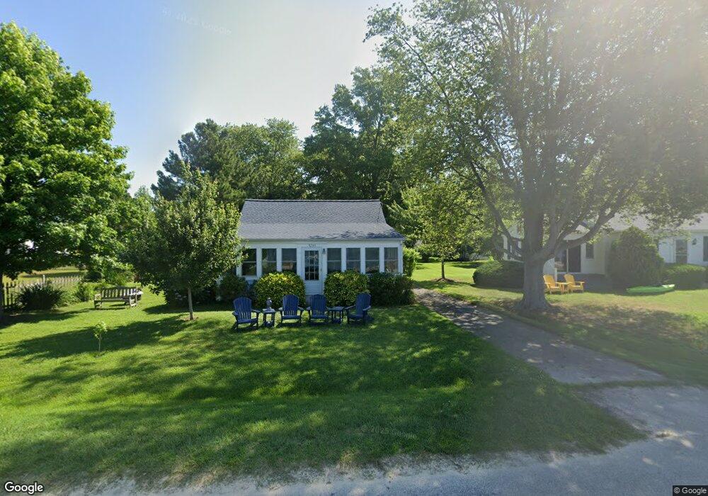
5795 Beach Rd Rock Hall, MD 21661
Estimated Value: $303,000 - $406,000
--
Bed
1
Bath
832
Sq Ft
$434/Sq Ft
Est. Value
About This Home
This home is located at 5795 Beach Rd, Rock Hall, MD 21661 and is currently estimated at $361,015, approximately $433 per square foot. 5795 Beach Rd is a home located in Kent County with nearby schools including Center for Innovation, Kent County Middle School, and Kent County High School.
Ownership History
Date
Name
Owned For
Owner Type
Purchase Details
Closed on
Aug 24, 2001
Sold by
Eld Llc
Bought by
Privor and Dumm Lios
Current Estimated Value
Purchase Details
Closed on
Jun 4, 2001
Sold by
Dinning Ernest L
Bought by
Eld Llc
Purchase Details
Closed on
May 11, 2001
Sold by
Miller George R and Miller Susan
Bought by
Dinning Ernest L
Purchase Details
Closed on
Nov 9, 1998
Sold by
Ashby Virginia T
Bought by
Miller George Riley
Purchase Details
Closed on
Apr 29, 1997
Sold by
Ashby Robert L and Ashby Virginia T
Bought by
Ashby Virginia T and Miller George R
Create a Home Valuation Report for This Property
The Home Valuation Report is an in-depth analysis detailing your home's value as well as a comparison with similar homes in the area
Home Values in the Area
Average Home Value in this Area
Purchase History
| Date | Buyer | Sale Price | Title Company |
|---|---|---|---|
| Privor | $174,500 | -- | |
| Eld Llc | -- | -- | |
| Dinning Ernest L | $142,000 | -- | |
| Miller George Riley | $28,500 | -- | |
| Miller George R | -- | -- | |
| Ashby Virginia T | -- | -- |
Source: Public Records
Tax History Compared to Growth
Tax History
| Year | Tax Paid | Tax Assessment Tax Assessment Total Assessment is a certain percentage of the fair market value that is determined by local assessors to be the total taxable value of land and additions on the property. | Land | Improvement |
|---|---|---|---|---|
| 2025 | $3,689 | $243,667 | $0 | $0 |
| 2024 | $3,648 | $239,400 | $181,100 | $58,300 |
| 2023 | $3,583 | $238,800 | $0 | $0 |
| 2022 | $3,583 | $238,200 | $0 | $0 |
| 2021 | $3,479 | $237,600 | $181,100 | $56,500 |
| 2020 | $3,479 | $236,000 | $0 | $0 |
| 2019 | $3,455 | $234,400 | $0 | $0 |
| 2018 | $3,385 | $232,800 | $181,100 | $51,700 |
| 2017 | $3,371 | $231,833 | $0 | $0 |
| 2016 | -- | $230,867 | $0 | $0 |
| 2015 | $3,635 | $229,900 | $0 | $0 |
| 2014 | $3,635 | $229,900 | $0 | $0 |
Source: Public Records
Map
Nearby Homes
- 5750 Walnut St
- 5980 Lawton Ave
- #2 Lawton Ave
- 5697 Walnut St
- 6119 New St Unit 2
- 5791 S Hawthorne Ave
- 21090 W Sharp St Unit 133
- 21090 W Sharp St Unit 112
- 21119 Striper Run
- 21163 Chesapeake Ave
- 21131 Striper Run
- 21133 Striper Run
- 21139 Striper Run
- 21141 Striper Run
- 5829 N Main St
- 21305 Haven Rd
- 5686 S Main St
- 5898 Williams St
- 21332 E Sharp St
- 21336 Haven Rd
- 5799 Beach Rd
- 5791 Beach Rd
- 0 Beach Rd Unit KE9779516
- 0 Beach Rd Unit MDKE2002912
- 0 Beach Rd Unit MDKE116600
- 0 Beach Rd Unit MDKE116552
- 0 Beach Rd Unit 1000083811
- 5787 Beach Rd
- 20685 Mercer Ave
- 5783 Beach Rd
- 20693 Bayside Ave
- 5798 Beach Rd
- 5815 Beach Rd
- 20697 Bayside Ave
- 20674 Mercer Ave
- 5779 Beach Rd
- 20705 Bayside Ave
- 5804 Beach Rd
- 5775 Beach Rd
- 20664 Mercer Ave