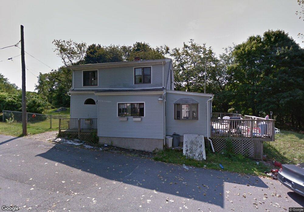
58 Clinton Ave Saugus, MA 01906
Downtown Saugus NeighborhoodEstimated Value: $576,000 - $656,000
2
Beds
1
Bath
1,436
Sq Ft
$427/Sq Ft
Est. Value
About This Home
This home is located at 58 Clinton Ave, Saugus, MA 01906 and is currently estimated at $613,157, approximately $426 per square foot. 58 Clinton Ave is a home located in Essex County with nearby schools including Saugus High School, Pioneer Charter School Of Science II, and Sacred Heart School.
Ownership History
Date
Name
Owned For
Owner Type
Purchase Details
Closed on
Nov 6, 2012
Sold by
Harris Ann M and Harris David A
Bought by
Mulry Anne M
Current Estimated Value
Purchase Details
Closed on
Sep 3, 2002
Sold by
Kilbride Ajmes T and Kilbride Susan J
Bought by
Harris David A and Harris Ann Marie
Purchase Details
Closed on
Oct 30, 1998
Sold by
Miller Gary L and Miller Deborah A
Bought by
Kilbride James T and Kilbride Susan J
Purchase Details
Closed on
Jun 14, 1995
Sold by
Bambury James C and Bambury Susan A
Bought by
Miller Garyl and Miller Deborah A
Purchase Details
Closed on
May 3, 1991
Sold by
Saugus Federal Cu
Bought by
Bambury James C
Create a Home Valuation Report for This Property
The Home Valuation Report is an in-depth analysis detailing your home's value as well as a comparison with similar homes in the area
Home Values in the Area
Average Home Value in this Area
Purchase History
| Date | Buyer | Sale Price | Title Company |
|---|---|---|---|
| Mulry Anne M | -- | -- | |
| Harris David A | $250,000 | -- | |
| Kilbride James T | $169,000 | -- | |
| Miller Garyl | $135,500 | -- | |
| Bambury James C | $105,000 | -- |
Source: Public Records
Mortgage History
| Date | Status | Borrower | Loan Amount |
|---|---|---|---|
| Previous Owner | Bambury James C | $72,500 | |
| Previous Owner | Bambury James C | $39,200 |
Source: Public Records
Tax History Compared to Growth
Tax History
| Year | Tax Paid | Tax Assessment Tax Assessment Total Assessment is a certain percentage of the fair market value that is determined by local assessors to be the total taxable value of land and additions on the property. | Land | Improvement |
|---|---|---|---|---|
| 2025 | $5,531 | $517,900 | $316,800 | $201,100 |
| 2024 | $5,286 | $496,300 | $298,700 | $197,600 |
| 2023 | $5,136 | $456,100 | $262,500 | $193,600 |
| 2022 | $4,972 | $414,000 | $240,700 | $173,300 |
| 2021 | $4,566 | $370,000 | $209,100 | $160,900 |
| 2020 | $4,291 | $360,000 | $199,100 | $160,900 |
| 2019 | $4,164 | $341,900 | $181,000 | $160,900 |
| 2018 | $3,797 | $327,900 | $175,600 | $152,300 |
| 2017 | $3,551 | $294,700 | $163,800 | $130,900 |
| 2016 | $3,167 | $259,600 | $163,600 | $96,000 |
| 2015 | $2,971 | $247,200 | $155,800 | $91,400 |
| 2014 | $3,064 | $263,900 | $155,800 | $108,100 |
Source: Public Records
Map
Nearby Homes
- 22 Laconia Ave
- 431 Central St
- 33 Springdale Ave
- 9 Oakwood Ave
- 483 Central St Unit A
- 5 Springdale Ave
- 25 Auburn St
- 17 Elaine Ave
- 4 Foss Ave
- 36 Jasper St
- 5 Stanley Terrace
- 32 Staaf Rd
- 18 Nason Rd
- 28 Emory St
- 6 Sim Rd Unit 1
- 12 Seagirt Ave
- 62 Chestnut St Unit 4
- 62 Chestnut St Unit 2
- 22 Seagirt Ave
- 4 Oneil Way