
Seller's Agent in 2025
Holly Bellucci
Keller Williams Realty Leading Edge
(401) 225-4943
1 in this area
169 Total Sales
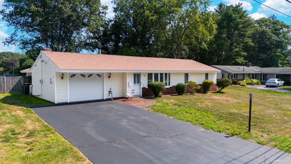
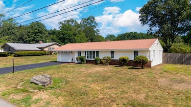
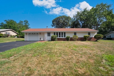
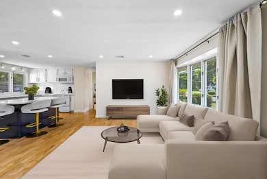
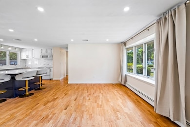
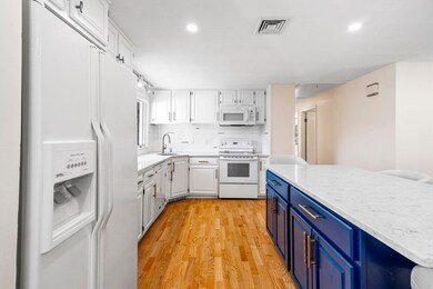
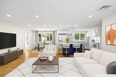
**OPEN HOUSE CANCELLED** Welcome to this fully updated oversized ranch nestled in a highly desirable neighborhood! This stunning home features a spacious great room with soaring ceilings, perfect for relaxing or entertaining. Enjoy warm summer days in your private backyard oasis with an inground pool, surrounded by meticulous landscaping and an irrigation system for easy maintenance. Inside, you'll find gleaming hardwood floors throughout, central air for year-round comfort, and a modern kitchen that flows seamlessly into the living and dining areas. The home also includes an alarm system for peace of mind and thoughtful updates throughout. Don’t miss this rare opportunity to own a move-in-ready home in a sought-after location—schedule your private showing today!
Last Agent to Sell the Property
Keller Williams Realty Leading Edge Listed on: 07/25/2025
| Date | Type | Sale Price | Title Company |
|---|---|---|---|
| Deed | $715,000 | -- | |
| Quit Claim Deed | $557,000 | None Available | |
| Quit Claim Deed | $557,000 | None Available | |
| Deed | $420,000 | -- | |
| Deed | $420,000 | -- | |
| Deed | $420,000 | -- |
| Date | Status | Loan Amount | Loan Type |
|---|---|---|---|
| Open | $643,500 | New Conventional | |
| Previous Owner | $473,450 | Purchase Money Mortgage | |
| Previous Owner | $89,617 | No Value Available | |
| Previous Owner | $315,000 | Purchase Money Mortgage |
| Date | Event | Price | List to Sale | Price per Sq Ft |
|---|---|---|---|---|
| 09/26/2025 09/26/25 | Sold | $715,000 | +2.2% | $481 / Sq Ft |
| 08/11/2025 08/11/25 | Pending | -- | -- | -- |
| 07/25/2025 07/25/25 | For Sale | $699,900 | -- | $470 / Sq Ft |
| Year | Tax Paid | Tax Assessment Tax Assessment Total Assessment is a certain percentage of the fair market value that is determined by local assessors to be the total taxable value of land and additions on the property. | Land | Improvement |
|---|---|---|---|---|
| 2025 | $6,935 | $580,800 | $272,300 | $308,500 |
| 2024 | $6,573 | $527,500 | $243,200 | $284,300 |
| 2023 | $6,228 | $475,800 | $217,100 | $258,700 |
| 2022 | $5,910 | $430,100 | $197,000 | $233,100 |
| 2021 | $5,761 | $410,000 | $189,400 | $220,600 |
| 2020 | $5,769 | $385,100 | $172,100 | $213,000 |
| 2019 | $5,652 | $367,500 | $172,100 | $195,400 |
| 2018 | $5,524 | $338,500 | $165,600 | $172,900 |
| 2017 | $5,377 | $321,800 | $160,800 | $161,000 |
| 2016 | $5,403 | $310,900 | $160,800 | $150,100 |
| 2015 | $5,301 | $297,500 | $161,100 | $136,400 |
Seller's Agent in 2025
Holly Bellucci
Keller Williams Realty Leading Edge
(401) 225-4943
1 in this area
169 Total Sales
S
Buyer's Agent in 2025
Strobeck Antonell Group
Compass
(617) 510-0375
1 in this area
158 Total Sales
Source: MLS Property Information Network (MLS PIN)
MLS Number: 73409396
APN: FRAM-000009-000040-007448
Disclaimer: Certain information contained herein is derived from information provided by parties other than Homes.com. All information provided is deemed reliable, but is not guaranteed to be accurate and should be independently verified.
![]() The property listing data and information, or the Images, set forth herein were provided to MLS Property Information Network, Inc. from third party sources, including sellers, lessors and public records, and were compiled by MLS Property Information Network, Inc. The property listing data and information, and the Images, are for the personal, non-commercial use of consumers having a good faith interest in purchasing or leasing listed properties of the type displayed to them and may not be used for any purpose other than to identify prospective properties which such consumers may have a good faith interest in purchasing or leasing. MLS Property Information Network, Inc. and its subscribers disclaim any and all representations and warranties as to the accuracy of the property listing data and information, or as to the accuracy of any of the Images, set forth herein.
The property listing data and information, or the Images, set forth herein were provided to MLS Property Information Network, Inc. from third party sources, including sellers, lessors and public records, and were compiled by MLS Property Information Network, Inc. The property listing data and information, and the Images, are for the personal, non-commercial use of consumers having a good faith interest in purchasing or leasing listed properties of the type displayed to them and may not be used for any purpose other than to identify prospective properties which such consumers may have a good faith interest in purchasing or leasing. MLS Property Information Network, Inc. and its subscribers disclaim any and all representations and warranties as to the accuracy of the property listing data and information, or as to the accuracy of any of the Images, set forth herein.