
Seller's Agent in 2025
Aziz Seyal
William Raveis Real Estate
(203) 209-9396
9 in this area
206 Total Sales
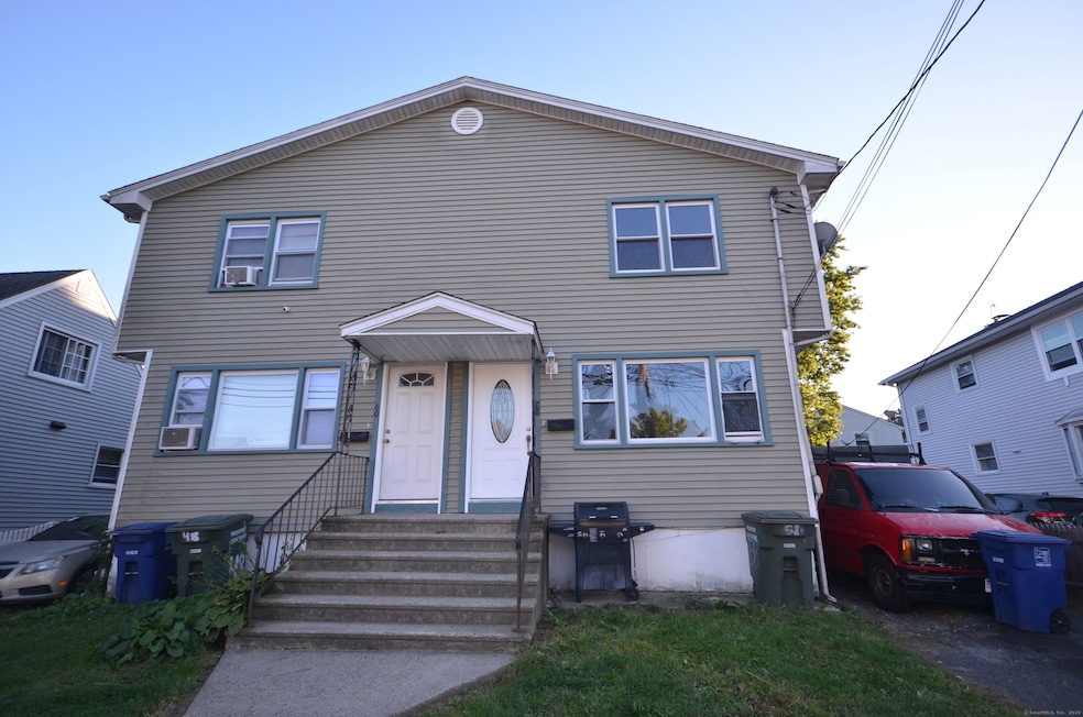
H&B by Saturday 10/4/25 at 7 pm. Great Duplex style side by side 2 family spacious house with 3 bedrooms and 1.5 bath on each side. Right side fully remodeled with Fresh Paint, New Kitchen and baths, Hardwood floors. Kitchen equipped with beautiful Custom-built white Shaker Cabinets, Quartz Countertops and stainless-steel appliances, quality tiles in kitchen and baths and hardwood floors throughout the house. Basement fully finished for family room/Playroom or Gym. Left side is rented for $2400 a month and is partially remodeled. Nice yard in the back. Great family Neighborhood near new Harding High School, Bridgeport Hospital, Shopping and restaurants. Also, Bus line is few minutes away.
Last Agent to Sell the Property
William Raveis Real Estate Brokerage Phone: (203) 209-9396 License #REB.0758112 Listed on: 09/26/2025
| Date | Type | Sale Price | Title Company |
|---|---|---|---|
| Warranty Deed | $475,000 | None Available | |
| Warranty Deed | $475,000 | None Available | |
| Warranty Deed | $259,900 | -- | |
| Warranty Deed | $259,900 | -- |
| Date | Status | Loan Amount | Loan Type |
|---|---|---|---|
| Previous Owner | $290,000 | No Value Available | |
| Previous Owner | $36,250 | No Value Available | |
| Previous Owner | $255,000 | No Value Available | |
| Previous Owner | $207,920 | Purchase Money Mortgage |
| Date | Event | Price | List to Sale | Price per Sq Ft |
|---|---|---|---|---|
| 11/05/2025 11/05/25 | Sold | $625,000 | 0.0% | $174 / Sq Ft |
| 11/04/2025 11/04/25 | Pending | -- | -- | -- |
| 09/28/2025 09/28/25 | For Sale | $625,000 | -- | $174 / Sq Ft |
| Year | Tax Paid | Tax Assessment Tax Assessment Total Assessment is a certain percentage of the fair market value that is determined by local assessors to be the total taxable value of land and additions on the property. | Land | Improvement |
|---|---|---|---|---|
| 2025 | $8,904 | $204,930 | $54,190 | $150,740 |
| 2024 | $8,904 | $204,930 | $54,190 | $150,740 |
| 2023 | $8,904 | $204,930 | $54,190 | $150,740 |
| 2022 | $8,904 | $204,930 | $54,190 | $150,740 |
| 2021 | $8,904 | $204,930 | $54,190 | $150,740 |
| 2020 | $7,708 | $142,760 | $25,400 | $117,360 |
| 2019 | $7,708 | $142,760 | $25,400 | $117,360 |
| 2018 | $7,762 | $142,760 | $25,400 | $117,360 |
| 2017 | $7,762 | $142,760 | $25,400 | $117,360 |
| 2016 | $7,762 | $142,760 | $25,400 | $117,360 |
| 2015 | $8,439 | $199,970 | $43,040 | $156,930 |
| 2014 | $8,439 | $199,970 | $43,040 | $156,930 |
Seller's Agent in 2025
Aziz Seyal
William Raveis Real Estate
(203) 209-9396
9 in this area
206 Total Sales
Buyer's Agent in 2025
Kimone Vassell
eXp Realty
(203) 600-6819
1 in this area
93 Total Sales
Source: SmartMLS
MLS Number: 24128534
APN: BRID-001913-000037B
Disclaimer: Certain information contained herein is derived from information provided by parties other than Homes.com. All information provided is deemed reliable, but is not guaranteed to be accurate and should be independently verified.
![]() IDX information is provided exclusively for personal, non-commercial use, and may not be used for any purpose other than to identify prospective properties consumers may be interested in purchasing. Information is deemed reliable but not guaranteed.
IDX information is provided exclusively for personal, non-commercial use, and may not be used for any purpose other than to identify prospective properties consumers may be interested in purchasing. Information is deemed reliable but not guaranteed.