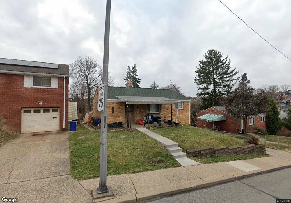
580 Beaufort Ave Pittsburgh, PA 15226
Brookline NeighborhoodEstimated Value: $181,000 - $200,000
3
Beds
1
Bath
875
Sq Ft
$222/Sq Ft
Est. Value
About This Home
This home is located at 580 Beaufort Ave, Pittsburgh, PA 15226 and is currently estimated at $194,600, approximately $222 per square foot. 580 Beaufort Ave is a home located in Allegheny County with nearby schools including Pittsburgh West Liberty K-5, Pittsburgh South Brook, and Pittsburgh Carrick High School.
Ownership History
Date
Name
Owned For
Owner Type
Purchase Details
Closed on
Jul 25, 2018
Sold by
Williams Marcia E
Bought by
Merichko Brian A and Williams Tiffany Lynn
Current Estimated Value
Home Financials for this Owner
Home Financials are based on the most recent Mortgage that was taken out on this home.
Original Mortgage
$105,000
Interest Rate
4.6%
Mortgage Type
New Conventional
Purchase Details
Closed on
Oct 14, 2017
Sold by
Williams Brian F and Williams Marcia E
Bought by
Williams Marcia E
Purchase Details
Closed on
Jul 8, 1993
Bought by
Williams Brian F and Williams Marcia E
Create a Home Valuation Report for This Property
The Home Valuation Report is an in-depth analysis detailing your home's value as well as a comparison with similar homes in the area
Home Values in the Area
Average Home Value in this Area
Purchase History
| Date | Buyer | Sale Price | Title Company |
|---|---|---|---|
| Merichko Brian A | $142,000 | Federal Appraisal & Closing | |
| Williams Marcia E | -- | None Available | |
| Williams Brian F | $50,000 | -- |
Source: Public Records
Mortgage History
| Date | Status | Borrower | Loan Amount |
|---|---|---|---|
| Previous Owner | Merichko Brian A | $105,000 |
Source: Public Records
Tax History Compared to Growth
Tax History
| Year | Tax Paid | Tax Assessment Tax Assessment Total Assessment is a certain percentage of the fair market value that is determined by local assessors to be the total taxable value of land and additions on the property. | Land | Improvement |
|---|---|---|---|---|
| 2025 | $1,493 | $64,800 | $26,100 | $38,700 |
| 2024 | $1,493 | $64,800 | $26,100 | $38,700 |
| 2023 | $1,493 | $64,800 | $26,100 | $38,700 |
| 2022 | $1,474 | $64,800 | $26,100 | $38,700 |
| 2021 | $1,904 | $64,800 | $26,100 | $38,700 |
| 2020 | $1,874 | $82,800 | $26,100 | $56,700 |
| 2019 | $1,874 | $82,800 | $26,100 | $56,700 |
| 2018 | $1,084 | $64,800 | $26,100 | $38,700 |
| 2017 | $1,466 | $64,800 | $26,100 | $38,700 |
| 2016 | $307 | $64,800 | $26,100 | $38,700 |
| 2015 | $307 | $64,800 | $26,100 | $38,700 |
| 2014 | $1,434 | $64,800 | $26,100 | $38,700 |
Source: Public Records
Map
Nearby Homes
- 405 Fernhill Ave
- 339 Fernhill Ave
- 320 Fernhill Ave
- 2033 Plainview Ave
- 711 Mayville Ave
- 728 Mayville Ave
- 2007 Plainview Ave
- 661 Dunster St
- 714 Dunster St
- 742 Mayville Ave
- 603 Crysler St
- 720 Dunster St
- 1937 Plainview Ave
- 2403 Lynnbrook Ave
- 2143 Plainview Ave
- 2054 Woodward Ave
- 2400 Pioneer Ave
- 863 Dunster St
- 2445 Edgebrook Ave
- 616 Rossmore Ave
- 586 Beaufort Ave
- 576 Beaufort Ave
- 608 Hartranft St
- 612 Hartranft St
- 619 Elmbank St
- 615 Elmbank St
- 566 Beaufort Ave
- 625 Elmbank St
- 585 Beaufort Ave
- 581 Beaufort Ave
- 616 Hartranft St
- 629 Elmbank St
- 589 Beaufort Ave
- 573 Beaufort Ave
- 000 Elwyn Rd
- 602 Beaufort Ave
- 567 Beaufort Ave
- 633 Elmbank St
- 613 Hartranft St
- 620 Hartranft St