Estimated Value: $539,420 - $584,000
3
Beds
3
Baths
1,832
Sq Ft
$308/Sq Ft
Est. Value
About This Home
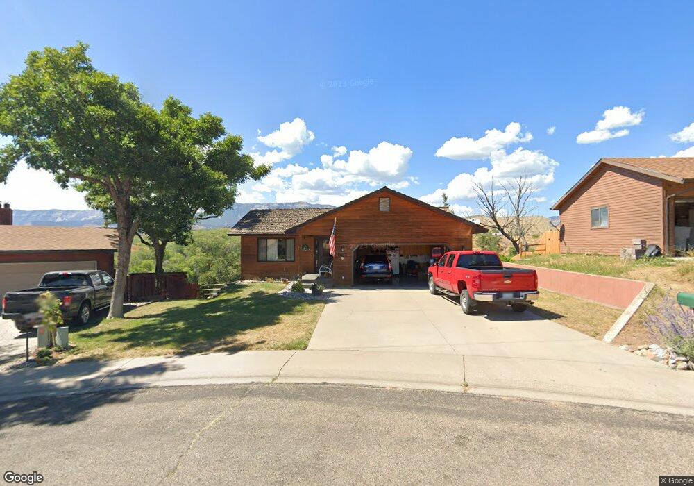
This home is located at 581 Mesa Ave, Rifle, CO 81650 and is currently estimated at $565,105, approximately $308 per square foot. 581 Mesa Ave is a home located in Garfield County with nearby schools including Graham Mesa Elementary School, Rifle Middle School, and Rifle High School.
Ownership History
Date
Name
Owned For
Owner Type
Purchase Details
Closed on
Aug 9, 2013
Sold by
Hatfield Fred D and Hatfield Marilyn I
Bought by
Kramp Donald R and Kramp Julie A
Current Estimated Value
Home Financials for this Owner
Home Financials are based on the most recent Mortgage that was taken out on this home.
Original Mortgage
$50,000
Interest Rate
4.49%
Mortgage Type
New Conventional
Purchase Details
Closed on
Oct 11, 2002
Sold by
Fenner Frederick R and Fenner Melanie A
Bought by
Hatfield Fred D and Hatfield Marilyn I
Home Financials for this Owner
Home Financials are based on the most recent Mortgage that was taken out on this home.
Original Mortgage
$162,400
Interest Rate
6.09%
Purchase Details
Closed on
Aug 13, 1999
Sold by
Walters Bradley E and Walters Jacqueline L
Bought by
Fenner Frederick R and Fenner Melanie A
Purchase Details
Closed on
Apr 8, 1992
Purchase Details
Closed on
Aug 27, 1990
Create a Home Valuation Report for This Property
The Home Valuation Report is an in-depth analysis detailing your home's value as well as a comparison with similar homes in the area
Home Values in the Area
Average Home Value in this Area
Purchase History
| Date | Buyer | Sale Price | Title Company |
|---|---|---|---|
| Kramp Donald R | $215,000 | Cwt | |
| Hatfield Fred D | $203,000 | -- | |
| Fenner Frederick R | $191,800 | -- | |
| Fenner Frederick R | $191,800 | -- | |
| -- | $9,500 | -- | |
| -- | $9,500 | -- | |
| -- | $8,500 | -- | |
| -- | $8,500 | -- |
Source: Public Records
Mortgage History
| Date | Status | Borrower | Loan Amount |
|---|---|---|---|
| Closed | Kramp Donald R | $50,000 | |
| Previous Owner | Hatfield Fred D | $162,400 |
Source: Public Records
Tax History
| Year | Tax Paid | Tax Assessment Tax Assessment Total Assessment is a certain percentage of the fair market value that is determined by local assessors to be the total taxable value of land and additions on the property. | Land | Improvement |
|---|---|---|---|---|
| 2024 | $2,548 | $28,770 | $5,640 | $23,130 |
| 2023 | $2,194 | $28,770 | $5,640 | $23,130 |
| 2022 | $1,663 | $23,230 | $5,210 | $18,020 |
| 2021 | $1,911 | $23,900 | $5,360 | $18,540 |
| 2020 | $1,515 | $20,710 | $3,150 | $17,560 |
| 2019 | $1,434 | $20,710 | $3,150 | $17,560 |
| 2018 | $1,354 | $19,130 | $2,950 | $16,180 |
| 2017 | $1,224 | $19,130 | $2,950 | $16,180 |
| 2016 | $969 | $17,150 | $2,870 | $14,280 |
| 2015 | $895 | $17,150 | $2,870 | $14,280 |
| 2014 | $558 | $10,620 | $1,950 | $8,670 |
Source: Public Records
Map
Nearby Homes
- 1617 W 7th St
- 124 Daniel Ave
- 1008 Wamsley Way
- 824 W 5th St
- 500 Fairway Ave
- 381 W 5th St Unit 2
- 751 Park Ave
- 2432 Pioneer Way
- 232 W 4th St
- 1165 Park Ave
- 758 Railroad Ave
- 629 Whiteriver Ave
- 216 E 1st St
- 292 Cowboy Dr
- 440 Whiteriver Ave
- 260 Cowboy Dr
- 258 Cowboy Dr
- 246 Cowboy Dr
- 224 Cowboy Dr
- 420 W 16th St
Your Personal Tour Guide
Ask me questions while you tour the home.