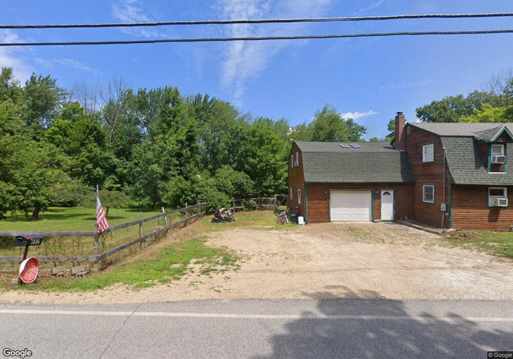
582 1st Crown Point Rd Strafford, NH 03884
Estimated Value: $552,000 - $675,000
4
Beds
2
Baths
3,000
Sq Ft
$207/Sq Ft
Est. Value
About This Home
This home is located at 582 1st Crown Point Rd, Strafford, NH 03884 and is currently estimated at $622,243, approximately $207 per square foot. 582 1st Crown Point Rd is a home located in Strafford County with nearby schools including Strafford School and Coe-Brown Northwood Academy.
Ownership History
Date
Name
Owned For
Owner Type
Purchase Details
Closed on
Dec 8, 2023
Sold by
Burkhead Maria E
Bought by
Burkhead Charles W
Current Estimated Value
Home Financials for this Owner
Home Financials are based on the most recent Mortgage that was taken out on this home.
Original Mortgage
$463,000
Outstanding Balance
$456,288
Interest Rate
7.76%
Mortgage Type
Stand Alone Refi Refinance Of Original Loan
Estimated Equity
$165,955
Purchase Details
Closed on
Apr 20, 2020
Sold by
Burkhead Maria E
Bought by
Burkhead Charles W and Burkhead Maria E
Home Financials for this Owner
Home Financials are based on the most recent Mortgage that was taken out on this home.
Original Mortgage
$267,000
Interest Rate
3.6%
Mortgage Type
New Conventional
Purchase Details
Closed on
Apr 27, 2018
Sold by
Richards Seth and Richards Abby
Bought by
Burkhead Maria E
Home Financials for this Owner
Home Financials are based on the most recent Mortgage that was taken out on this home.
Original Mortgage
$268,000
Interest Rate
3.99%
Mortgage Type
New Conventional
Create a Home Valuation Report for This Property
The Home Valuation Report is an in-depth analysis detailing your home's value as well as a comparison with similar homes in the area
Home Values in the Area
Average Home Value in this Area
Purchase History
| Date | Buyer | Sale Price | Title Company |
|---|---|---|---|
| Burkhead Charles W | -- | None Available | |
| Burkhead Charles W | -- | None Available | |
| Burkhead Charles W | -- | None Available | |
| Burkhead Maria E | $335,000 | -- | |
| Burkhead Maria E | $335,000 | -- |
Source: Public Records
Mortgage History
| Date | Status | Borrower | Loan Amount |
|---|---|---|---|
| Open | Burkhead Charles W | $463,000 | |
| Previous Owner | Burkhead Charles W | $267,000 | |
| Previous Owner | Burkhead Maria E | $268,000 |
Source: Public Records
Tax History Compared to Growth
Tax History
| Year | Tax Paid | Tax Assessment Tax Assessment Total Assessment is a certain percentage of the fair market value that is determined by local assessors to be the total taxable value of land and additions on the property. | Land | Improvement |
|---|---|---|---|---|
| 2024 | $7,568 | $383,000 | $66,300 | $316,700 |
| 2023 | $7,139 | $383,000 | $66,300 | $316,700 |
| 2022 | $6,566 | $383,300 | $66,600 | $316,700 |
| 2021 | $6,708 | $363,400 | $66,700 | $296,700 |
| 2020 | $6,333 | $246,900 | $59,600 | $187,300 |
| 2019 | $5,795 | $246,900 | $59,600 | $187,300 |
| 2018 | $5,865 | $248,200 | $59,500 | $188,700 |
| 2016 | $5,279 | $248,400 | $59,700 | $188,700 |
| 2015 | $4,909 | $225,100 | $72,700 | $152,400 |
| 2014 | $5,213 | $225,100 | $72,700 | $152,400 |
| 2013 | $5,160 | $227,500 | $72,800 | $154,700 |
| 2012 | $5,094 | $227,600 | $72,900 | $154,700 |
Source: Public Records
Map
Nearby Homes
- 825 Second Crown Point Rd
- 8 King Arthur Dr
- 30 Avalon Rd
- TBD Merlin Rd
- 00 Squire Rd
- 948 Strafford Rd
- 1226 First Crown Point Rd
- 0 Strafford Rd Unit 5057984
- 38 Strafford Rd
- 479 Ten Rod Rd
- 83 Sloper Rd
- Map 220 Lot 16 Four Rod Rd
- 0 Sloper Rd Unit 6
- 243 Second Crown Point Rd
- 86 Long Shores Dr
- 68 Berry River Rd
- 22 Stonewall Dr
- 57 Batchelder Ln
- 0 Long Shores Dr Unit 5057687
- 210 Ten Rod Rd
- 582 1st Crown Point Rd
- 574 1st Crown Point Rd
- 575 1st Crown Point Rd
- 592 1st Crown Point Rd
- 567 1st Crown Point Rd
- 591 First Crown Point Rd
- 591 1st Crown Point Rd
- 562 1st Crown Point Rd
- 562 1st Crown Point Rd
- 599 1st Crown Point Rd
- 602 1st Crown Point Rd
- 609 1st Crown Point Rd
- 552 1st Crown Point Rd
- 620 1st Crown Point Rd
- 620 1st Crown Point Rd
- 533 1st Crown Point Rd
- 550 1st Crown Point Rd
- 550 1st Crown Point Rd
- 526 1st Crown Point Rd
- 636 1st Crown Point Rd