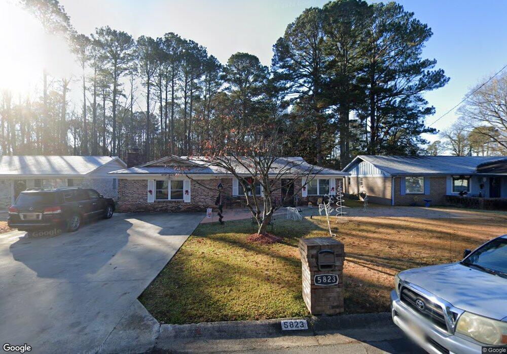
5823 Palo Alto Dr Little Rock, AR 72209
Upper Baseline NeighborhoodEstimated Value: $125,303 - $157,000
--
Bed
2
Baths
1,650
Sq Ft
$87/Sq Ft
Est. Value
About This Home
This home is located at 5823 Palo Alto Dr, Little Rock, AR 72209 and is currently estimated at $144,326, approximately $87 per square foot. 5823 Palo Alto Dr is a home located in Pulaski County with nearby schools including Watson Elementary School, Cloverdale Middle School, and Little Rock Southwest High School.
Ownership History
Date
Name
Owned For
Owner Type
Purchase Details
Closed on
Jun 15, 2001
Sold by
Higgins Loretta P and Little Doris P
Bought by
Cokeley James J and Cokeley Gwendolyn D
Current Estimated Value
Home Financials for this Owner
Home Financials are based on the most recent Mortgage that was taken out on this home.
Original Mortgage
$66,150
Outstanding Balance
$25,143
Interest Rate
7.11%
Mortgage Type
VA
Estimated Equity
$119,183
Create a Home Valuation Report for This Property
The Home Valuation Report is an in-depth analysis detailing your home's value as well as a comparison with similar homes in the area
Home Values in the Area
Average Home Value in this Area
Purchase History
| Date | Buyer | Sale Price | Title Company |
|---|---|---|---|
| Cokeley James J | $65,000 | First National Title Company |
Source: Public Records
Mortgage History
| Date | Status | Borrower | Loan Amount |
|---|---|---|---|
| Open | Cokeley James J | $66,150 |
Source: Public Records
Tax History Compared to Growth
Tax History
| Year | Tax Paid | Tax Assessment Tax Assessment Total Assessment is a certain percentage of the fair market value that is determined by local assessors to be the total taxable value of land and additions on the property. | Land | Improvement |
|---|---|---|---|---|
| 2025 | $1,156 | $23,414 | $2,600 | $20,814 |
| 2024 | $1,156 | $23,414 | $2,600 | $20,814 |
| 2023 | $1,156 | $23,414 | $2,600 | $20,814 |
| 2022 | $1,156 | $23,414 | $2,600 | $20,814 |
| 2021 | $1,165 | $16,520 | $4,300 | $12,220 |
| 2020 | $781 | $16,520 | $4,300 | $12,220 |
| 2019 | $781 | $16,520 | $4,300 | $12,220 |
| 2018 | $806 | $16,520 | $4,300 | $12,220 |
| 2017 | $806 | $16,520 | $4,300 | $12,220 |
| 2016 | $776 | $16,090 | $2,760 | $13,330 |
| 2015 | $1,128 | $16,090 | $2,760 | $13,330 |
| 2014 | $1,128 | $15,977 | $2,760 | $13,217 |
Source: Public Records
Map
Nearby Homes
- 5817 Drexel Ave
- 5823 Liberty Cove
- 10407 Republic Ln
- 22 Old Glory Ct
- 00 Lovett Dr
- 6711 Woodfield Rd
- 10001 Warren Dr
- 5300 Southboro Ct
- 000 Geyer Springs Rd
- 6611 Fairfield Dr
- 6313 Senate Dr
- 9901 Eva Ln
- 0000 Eva Ln
- 7101 Redwood Dr
- 7216 Mabelvale Cut Off
- 7009 Guinevere Dr
- 7120 Redwood Dr
- 9220 Reck Rd
- 8616 Dreher Ln
- 7307 Knollwood Rd
- 5819 Palo Alto Dr
- 5901 Palo Alto Dr
- 5909 Palo Alto Dr
- 5811 Palo Alto Dr
- 5824 Palo Alto Dr
- 5915 Palo Alto Dr
- 5818 Palo Alto Dr
- 5812 Palo Alto Dr
- 5910 Palo Alto Dr
- 5801 Palo Alto Dr
- 5919 Palo Alto Dr
- 5808 Palo Alto Dr
- 5914 Palo Alto Dr
- 5800 Palo Alto Dr
- 5920 Palo Alto Dr
- 5723 Palo Alto Dr
- 5821 Drexel Ave
- 10119 Geyer Springs Rd
- 10223 Geyer Springs Rd