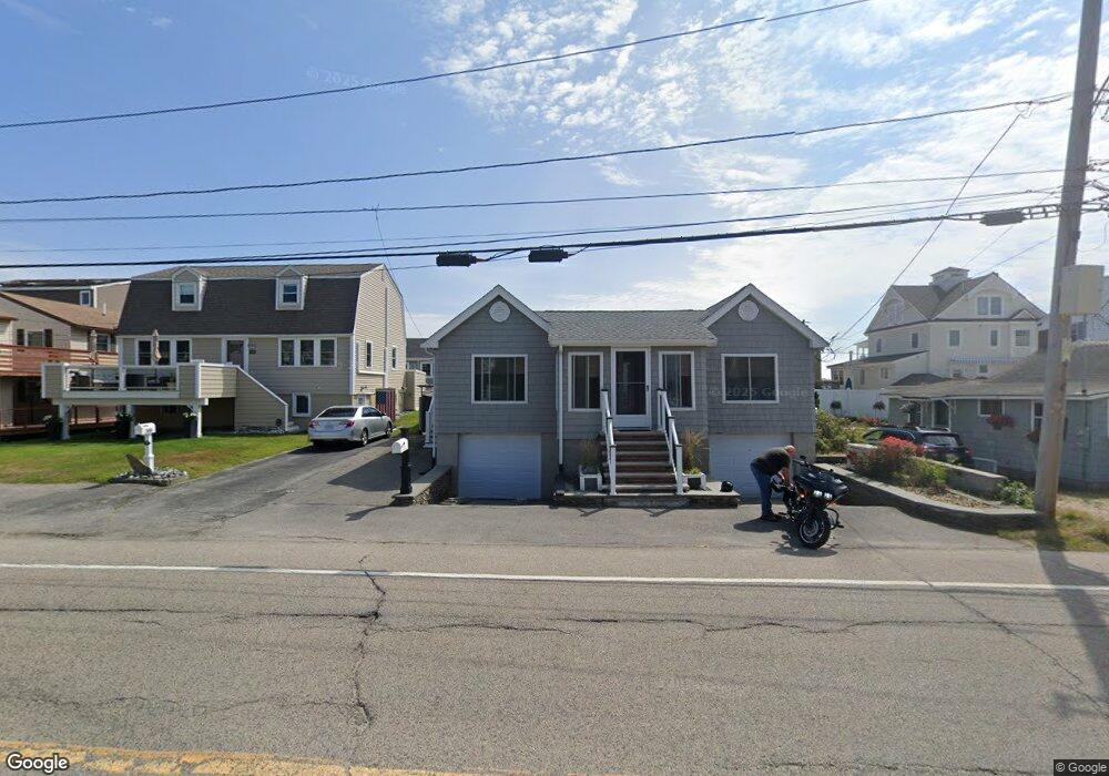
586 North End Blvd Salisbury, MA 01952
Estimated Value: $687,000 - $853,000
3
Beds
2
Baths
1,176
Sq Ft
$657/Sq Ft
Est. Value
About This Home
This home is located at 586 North End Blvd, Salisbury, MA 01952 and is currently estimated at $772,688, approximately $657 per square foot. 586 North End Blvd is a home located in Essex County with nearby schools including Triton Regional High School.
Ownership History
Date
Name
Owned For
Owner Type
Purchase Details
Closed on
Aug 13, 2024
Sold by
Underwood Jill M and Underwood Kevin J
Bought by
K J & J M Underwood Ret and Underwood
Current Estimated Value
Purchase Details
Closed on
Mar 31, 2020
Sold by
Jay F Zaino Ret
Bought by
Underwood Kevin J and Underwood Jill M
Home Financials for this Owner
Home Financials are based on the most recent Mortgage that was taken out on this home.
Original Mortgage
$750,000
Interest Rate
3.4%
Mortgage Type
Purchase Money Mortgage
Purchase Details
Closed on
Mar 17, 2020
Sold by
Howes Brandon and Howes Holly
Bought by
Gabriel Kenneth M and Gabriel Jamie L
Home Financials for this Owner
Home Financials are based on the most recent Mortgage that was taken out on this home.
Original Mortgage
$750,000
Interest Rate
3.4%
Mortgage Type
Purchase Money Mortgage
Purchase Details
Closed on
Mar 28, 2018
Sold by
Rubin Mark D and Rubin Gloria B
Bought by
Howes Brandon and Donahue Holly
Home Financials for this Owner
Home Financials are based on the most recent Mortgage that was taken out on this home.
Original Mortgage
$900,000
Interest Rate
4.38%
Mortgage Type
Purchase Money Mortgage
Purchase Details
Closed on
Dec 12, 2016
Sold by
Dorman Eric V
Bought by
Jay F Zaino Ret and Zaino
Purchase Details
Closed on
Apr 15, 2011
Sold by
Auclair Ronald L and Auclair Deborah
Bought by
Dorman Eric V
Purchase Details
Closed on
Jun 13, 2008
Sold by
Daher George R Est and Daher
Bought by
Auclair Deborah and Auclair Ronald L
Purchase Details
Closed on
Nov 28, 2005
Sold by
Mulligan John J
Bought by
Rubin Gloria B and Rubin Mark D
Purchase Details
Closed on
Sep 5, 2000
Sold by
Willis Family Nt
Bought by
Mulligan John J and Mulligan Maureen A
Home Financials for this Owner
Home Financials are based on the most recent Mortgage that was taken out on this home.
Original Mortgage
$428,000
Interest Rate
8.16%
Mortgage Type
Purchase Money Mortgage
Create a Home Valuation Report for This Property
The Home Valuation Report is an in-depth analysis detailing your home's value as well as a comparison with similar homes in the area
Home Values in the Area
Average Home Value in this Area
Purchase History
| Date | Buyer | Sale Price | Title Company |
|---|---|---|---|
| K J & J M Underwood Ret | -- | None Available | |
| K J & J M Underwood Ret | -- | None Available | |
| Underwood Kevin J | $561,000 | None Available | |
| Gabriel Kenneth M | $1,185,000 | None Available | |
| Howes Brandon | $1,250,000 | -- | |
| Jay F Zaino Ret | $550,000 | -- | |
| Dorman Eric V | $340,000 | -- | |
| Auclair Deborah | $385,000 | -- | |
| Auclair Deborah | $385,000 | -- | |
| Rubin Gloria B | $1,193,656 | -- | |
| Mulligan John J | $535,000 | -- | |
| Auclair Deborah | $385,000 | -- |
Source: Public Records
Mortgage History
| Date | Status | Borrower | Loan Amount |
|---|---|---|---|
| Previous Owner | Gabriel Kenneth M | $750,000 | |
| Previous Owner | Howes Brandon | $900,000 | |
| Previous Owner | Mulligan John J | $428,000 | |
| Closed | Mulligan John J | $26,750 |
Source: Public Records
Tax History
| Year | Tax Paid | Tax Assessment Tax Assessment Total Assessment is a certain percentage of the fair market value that is determined by local assessors to be the total taxable value of land and additions on the property. | Land | Improvement |
|---|---|---|---|---|
| 2025 | $7,439 | $738,000 | $409,000 | $329,000 |
| 2024 | $7,682 | $735,100 | $409,000 | $326,100 |
| 2023 | $4,885 | $596,600 | $361,500 | $235,100 |
| 2022 | $4,728 | $596,600 | $361,500 | $235,100 |
| 2021 | $4,765 | $583,000 | $361,500 | $221,500 |
| 2020 | $6,818 | $594,900 | $361,500 | $233,400 |
| 2019 | $4,723 | $556,900 | $342,500 | $214,400 |
| 2018 | $4,685 | $550,800 | $342,500 | $208,300 |
| 2017 | $4,425 | $449,700 | $320,900 | $128,800 |
| 2016 | $4,884 | $418,500 | $288,800 | $129,700 |
Source: Public Records
Map
Nearby Homes
- 42 Commonwealth Ave
- 308 State Route 286 Unit Lot 73
- 308 State Route 286 Unit Lot 108
- 308 State Route 286 Unit Lot 23
- 308 State Route 286 Unit Lot 87
- 492 N End Blvd
- 432 N End Blvd
- 308 Route 286 Unit Lot 58
- 3 Tyngsboro St
- 9 Tyngsboro St
- 27 Cross Beach Rd
- 376 Ocean Blvd
- 78 Pembroke St
- 23 River St
- 108 Ocean Dr Unit 1
- 178 N End Blvd Unit G
- 19 Viola Cir
- 8 Portsmouth Ave
- 71 Cynthia Cir
- 17 Brown Ave
- 586 N End Blvd
- 584 North End Blvd
- 588 N End Blvd
- 588 North End Blvd
- 590 North End Blvd Unit 4
- 590 North End Blvd Unit 3
- 590 North End Blvd Unit 2
- 590 North End Blvd Unit 1
- 8 Commonwealth Ave
- 8 Commonwealth Ave Unit 1
- 8 Commonwealth Ave Unit 2
- 8 Commonwealth Ave Unit 2 UP
- 8 Commonwealth Ave Unit 1 down
- 8 Commonwealth Ave Unit 2
- 8 Commonwealth Ave Unit 1
- 590 N End Blvd
- 6 Commonwealth Ave
- 582 North End Blvd
- 4 Commonwealth Ave
- 10 Commonwealth Ave
Your Personal Tour Guide
Ask me questions while you tour the home.