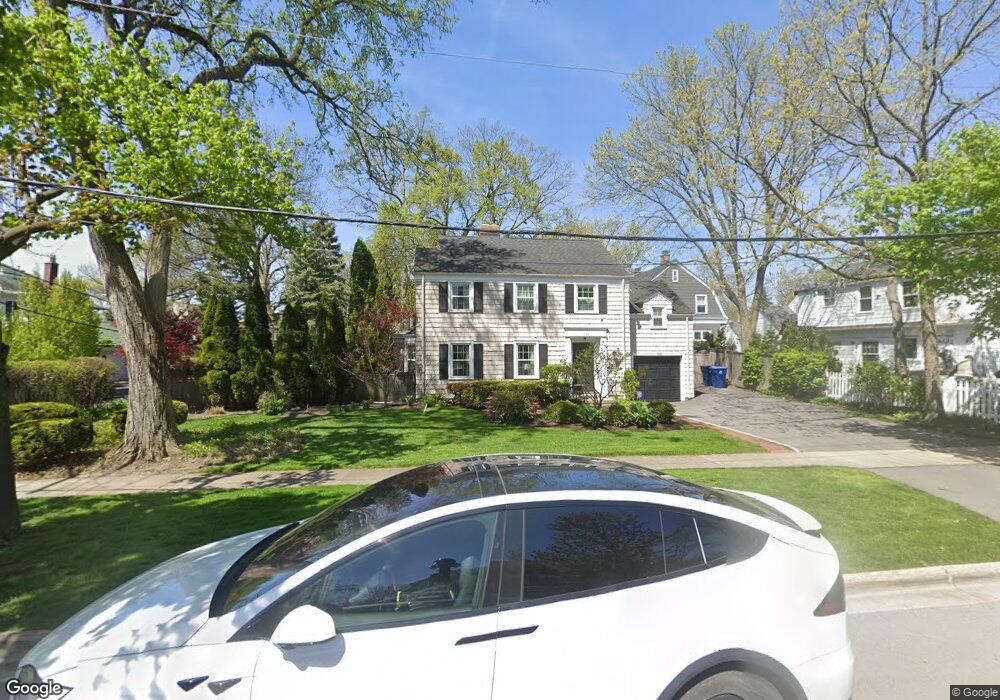
588 Grove St Glencoe, IL 60022
Estimated Value: $963,000 - $1,142,000
4
Beds
3
Baths
1,856
Sq Ft
$585/Sq Ft
Est. Value
About This Home
This home is located at 588 Grove St, Glencoe, IL 60022 and is currently estimated at $1,085,769, approximately $585 per square foot. 588 Grove St is a home located in Cook County with nearby schools including South Elementary School, Central School, and West School.
Ownership History
Date
Name
Owned For
Owner Type
Purchase Details
Closed on
Jul 7, 2001
Sold by
Falk Joel C and Falk Barbara A
Bought by
Roth Laura G
Current Estimated Value
Home Financials for this Owner
Home Financials are based on the most recent Mortgage that was taken out on this home.
Original Mortgage
$350,000
Outstanding Balance
$127,582
Interest Rate
6.87%
Estimated Equity
$958,187
Purchase Details
Closed on
Apr 20, 1994
Sold by
American National Bk & Tr Co Of Chicago
Bought by
Falk Joel C and Falk Barbara A
Home Financials for this Owner
Home Financials are based on the most recent Mortgage that was taken out on this home.
Original Mortgage
$315,000
Interest Rate
7%
Create a Home Valuation Report for This Property
The Home Valuation Report is an in-depth analysis detailing your home's value as well as a comparison with similar homes in the area
Home Values in the Area
Average Home Value in this Area
Purchase History
| Date | Buyer | Sale Price | Title Company |
|---|---|---|---|
| Roth Laura G | $575,000 | Commonwealth Land Title Ins | |
| Falk Joel C | -- | Centennial Title Incorporate |
Source: Public Records
Mortgage History
| Date | Status | Borrower | Loan Amount |
|---|---|---|---|
| Open | Roth Laura G | $350,000 | |
| Previous Owner | Falk Joel C | $315,000 |
Source: Public Records
Tax History Compared to Growth
Tax History
| Year | Tax Paid | Tax Assessment Tax Assessment Total Assessment is a certain percentage of the fair market value that is determined by local assessors to be the total taxable value of land and additions on the property. | Land | Improvement |
|---|---|---|---|---|
| 2025 | $14,865 | $79,879 | $20,405 | $59,474 |
| 2024 | $14,865 | $60,512 | $17,266 | $43,246 |
| 2023 | $16,369 | $68,915 | $17,266 | $51,649 |
| 2022 | $16,369 | $75,000 | $17,266 | $57,734 |
| 2021 | $13,392 | $50,040 | $14,126 | $35,914 |
| 2020 | $13,065 | $50,040 | $14,126 | $35,914 |
| 2019 | $13,312 | $57,259 | $14,126 | $43,133 |
| 2018 | $13,311 | $55,796 | $11,772 | $44,024 |
| 2017 | $12,946 | $55,796 | $11,772 | $44,024 |
| 2016 | $14,593 | $65,429 | $11,772 | $53,657 |
| 2015 | $13,695 | $54,911 | $9,810 | $45,101 |
| 2014 | $13,584 | $55,746 | $9,810 | $45,936 |
| 2013 | $12,942 | $55,746 | $9,810 | $45,936 |
Source: Public Records
Map
Nearby Homes
- 476 Park Ave
- 488 Park Ave
- 490 Jefferson Ave
- 590 Green Bay Rd Unit 590
- 343 Washington Ave
- 794 Greenwood Ave
- 410 Green Bay Rd
- 396 Forest Edge Dr
- 677 Greenleaf Ave
- 285 Vernon Ave
- 265 Randolph St
- 908 Elm Place
- 64 Crescent Dr
- 610 Drexel Ave
- 219 Lincoln Dr
- 165 Lapier St
- 759 Strawberry Hill Dr
- 1492 Asbury Ave
- 130 Maple Hill Rd
- 150 Linden Ave