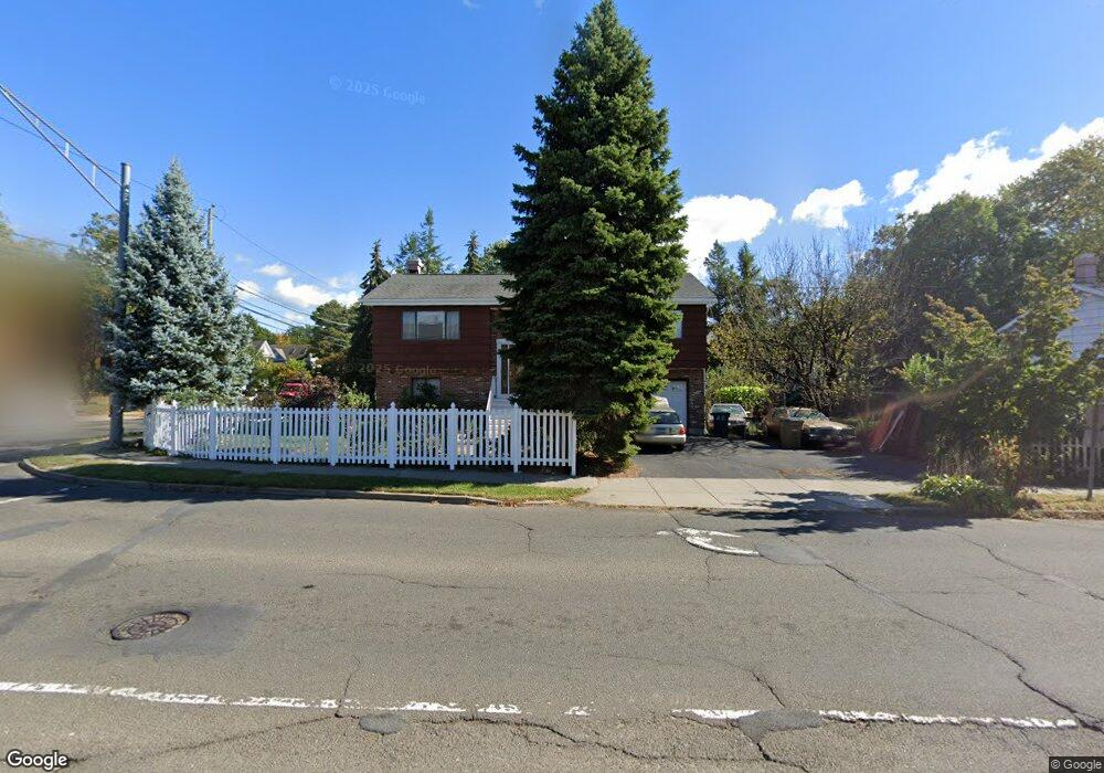
589 Glenbrook Rd Stamford, CT 06906
Glenbrook NeighborhoodEstimated Value: $729,000 - $781,735
4
Beds
2
Baths
2,102
Sq Ft
$357/Sq Ft
Est. Value
About This Home
This home is located at 589 Glenbrook Rd, Stamford, CT 06906 and is currently estimated at $749,934, approximately $356 per square foot. 589 Glenbrook Rd is a home located in Fairfield County with nearby schools including Julia A. Stark Elementary School, Dolan School, and Stamford High School.
Ownership History
Date
Name
Owned For
Owner Type
Purchase Details
Closed on
Jul 14, 1988
Sold by
Hauschild J
Bought by
Kapakos Dimitrios
Current Estimated Value
Create a Home Valuation Report for This Property
The Home Valuation Report is an in-depth analysis detailing your home's value as well as a comparison with similar homes in the area
Home Values in the Area
Average Home Value in this Area
Purchase History
| Date | Buyer | Sale Price | Title Company |
|---|---|---|---|
| Kapakos Dimitrios | $260,000 | -- |
Source: Public Records
Mortgage History
| Date | Status | Borrower | Loan Amount |
|---|---|---|---|
| Open | Kapakos Dimitrios | $137,500 | |
| Closed | Kapakos Dimitrios | $100,000 | |
| Closed | Kapakos Dimitrios | $188,600 | |
| Closed | Kapakos Dimitrios | $177,500 |
Source: Public Records
Tax History Compared to Growth
Tax History
| Year | Tax Paid | Tax Assessment Tax Assessment Total Assessment is a certain percentage of the fair market value that is determined by local assessors to be the total taxable value of land and additions on the property. | Land | Improvement |
|---|---|---|---|---|
| 2025 | $9,067 | $383,200 | $220,910 | $162,290 |
| 2024 | $8,867 | $383,200 | $220,910 | $162,290 |
| 2023 | $9,526 | $383,200 | $220,910 | $162,290 |
| 2022 | $8,180 | $305,910 | $169,610 | $136,300 |
| 2021 | $8,091 | $305,910 | $169,610 | $136,300 |
| 2020 | $7,883 | $305,910 | $169,610 | $136,300 |
| 2019 | $7,883 | $305,910 | $169,610 | $136,300 |
| 2018 | $7,593 | $305,910 | $169,610 | $136,300 |
| 2017 | $7,026 | $270,220 | $142,480 | $127,740 |
| 2016 | $6,828 | $270,220 | $142,480 | $127,740 |
| 2015 | $6,650 | $270,220 | $142,480 | $127,740 |
| 2014 | $6,429 | $270,220 | $142,480 | $127,740 |
Source: Public Records
Map
Nearby Homes
- 596 Glenbrook Rd Unit 36
- 406 Courtland Ave Unit D
- 34 Crescent St Unit 2D
- 30 Maple Tree Ave Unit D
- 43 Crescent St Unit 11
- 35 Maple Tree Ave Unit 6
- 62 Maple Tree Ave Unit 62
- 69 Maple Tree Ave Unit 4
- 88 Maple Tree Ave Unit G
- 30 Lenox Ave
- 415 West Ave
- 8 Windell Place
- 98 Holmes Ave
- 51 Glendale Rd
- 88 Pine Hill Ave
- 30 Lake Dr
- 90 Courtland Hill St
- 31 Bellmere Ave
- 151 Courtland Ave Unit 4
- 75 Coolidge Ave
- 446 Courtland Ave
- 446 Courtland Ave Unit 446
- 445 Courtland Ave
- 440 Courtland Ave
- 440 Courtland Ave Unit 440
- 440 Courtland Ave Unit 440+444
- 442 Courtland Ave
- 444 Courtland Ave
- 579 Glenbrook Rd
- 439 Courtland Ave
- 430 Courtland Ave
- 428 Courtland Ave
- 433 Courtland Ave
- 432 Courtland Ave
- 432 Courtland Ave Unit 432
- 434 Courtland Ave
- 434 Courtland Ave Unit 434
- 436 Courtland Ave
- 575 Glenbrook Rd
- 575 Glenbrook Rd Unit 1