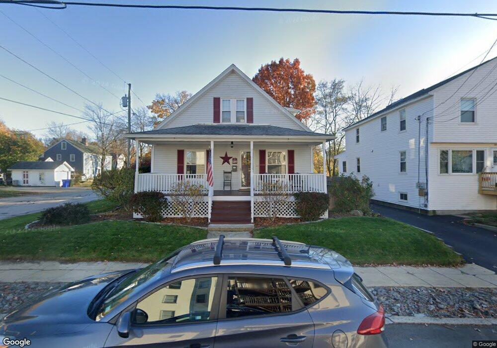
589 Spruce St Manchester, NH 03103
Hallsville NeighborhoodEstimated Value: $399,000 - $425,000
3
Beds
2
Baths
1,512
Sq Ft
$272/Sq Ft
Est. Value
About This Home
This home is located at 589 Spruce St, Manchester, NH 03103 and is currently estimated at $411,312, approximately $272 per square foot. 589 Spruce St is a home located in Hillsborough County with nearby schools including Jewett Street Elementary School, Southside Middle School, and Manchester Memorial High School.
Ownership History
Date
Name
Owned For
Owner Type
Purchase Details
Closed on
Jun 3, 2003
Sold by
Genest David D and Genest Kelly A
Bought by
Hurley Kimberly J
Current Estimated Value
Home Financials for this Owner
Home Financials are based on the most recent Mortgage that was taken out on this home.
Original Mortgage
$190,000
Interest Rate
5.86%
Create a Home Valuation Report for This Property
The Home Valuation Report is an in-depth analysis detailing your home's value as well as a comparison with similar homes in the area
Home Values in the Area
Average Home Value in this Area
Purchase History
| Date | Buyer | Sale Price | Title Company |
|---|---|---|---|
| Hurley Kimberly J | $200,000 | -- |
Source: Public Records
Mortgage History
| Date | Status | Borrower | Loan Amount |
|---|---|---|---|
| Open | Hurley Kimberly J | $255,899 | |
| Closed | Hurley Kimberly J | $191,000 | |
| Closed | Hurley Kimberly J | $25,000 | |
| Closed | Hurley Kimberly J | $190,000 |
Source: Public Records
Tax History Compared to Growth
Tax History
| Year | Tax Paid | Tax Assessment Tax Assessment Total Assessment is a certain percentage of the fair market value that is determined by local assessors to be the total taxable value of land and additions on the property. | Land | Improvement |
|---|---|---|---|---|
| 2024 | $5,592 | $285,600 | $84,600 | $201,000 |
| 2023 | $5,386 | $285,600 | $84,600 | $201,000 |
| 2022 | $5,209 | $285,600 | $84,600 | $201,000 |
| 2021 | $5,049 | $285,600 | $84,600 | $201,000 |
| 2020 | $4,752 | $192,700 | $58,300 | $134,400 |
| 2019 | $4,686 | $192,700 | $58,300 | $134,400 |
| 2018 | $4,111 | $192,700 | $58,300 | $134,400 |
| 2017 | $4,031 | $192,700 | $58,300 | $134,400 |
| 2016 | $4,459 | $192,700 | $58,300 | $134,400 |
| 2015 | $4,334 | $184,900 | $58,300 | $126,600 |
| 2014 | $4,345 | $184,900 | $58,300 | $126,600 |
| 2013 | $4,192 | $184,900 | $58,300 | $126,600 |
Source: Public Records
Map
Nearby Homes
- 440 Laurel St
- 10 Hayes Ave
- 662 Amherst St
- 335 Cypress St Unit 4A
- 335 Cypress St Unit 2P
- 203 Portsmouth Ave
- 527 Hanover St
- 146 Woodbine Ave
- 651 Summer St
- 635 Green St
- 625 Green St
- 201 Jewett St
- 173 Mammoth Rd
- 167 Mammoth Rd
- 426 Manchester St
- 445 E High St
- 601 Hall St
- 383 Concord St
- 383 Concord St Hcrd Plan 42577
- 165 Taylor St
- 585 Spruce St Unit 2
- 583 Spruce ( Upper) St Unit 1
- 583 Spruce ( Upper) St
- 583 Spruce St Unit 1
- 597 Spruce St
- 581 Spruce St
- 68 Kenney St
- 42 Kenney St
- 577 Spruce St
- 599 Soruce
- 578/B Spruce St
- 970 Cedar St
- 39 Kenney St
- 599 Spruce St
- 598 Spruce St
- 80 Kenney St
- 578 Spruce (One Block To Park) St
- 578 Spruce St
- 582 Spruce St
- 573 Spruce St