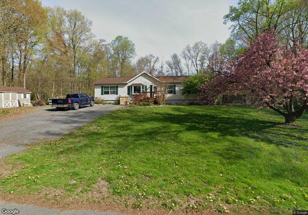
5891 Timothy Dr Narvon, PA 17555
Estimated Value: $314,000 - $432,000
3
Beds
2
Baths
1,680
Sq Ft
$226/Sq Ft
Est. Value
About This Home
This home is located at 5891 Timothy Dr, Narvon, PA 17555 and is currently estimated at $379,243, approximately $225 per square foot. 5891 Timothy Dr is a home located in Lancaster County with nearby schools including Pequea Valley Intermediate School, Pequea Valley High School, and Beartown School.
Ownership History
Date
Name
Owned For
Owner Type
Purchase Details
Closed on
Mar 28, 2002
Sold by
Gabriel Brian and Gabriel Gema
Bought by
Schroeder Frederick J and Schroeder Joyce L
Current Estimated Value
Home Financials for this Owner
Home Financials are based on the most recent Mortgage that was taken out on this home.
Original Mortgage
$27,500
Outstanding Balance
$11,457
Interest Rate
6.88%
Estimated Equity
$367,786
Create a Home Valuation Report for This Property
The Home Valuation Report is an in-depth analysis detailing your home's value as well as a comparison with similar homes in the area
Home Values in the Area
Average Home Value in this Area
Purchase History
| Date | Buyer | Sale Price | Title Company |
|---|---|---|---|
| Schroeder Frederick J | $40,000 | -- |
Source: Public Records
Mortgage History
| Date | Status | Borrower | Loan Amount |
|---|---|---|---|
| Open | Schroeder Frederick J | $27,500 |
Source: Public Records
Tax History Compared to Growth
Tax History
| Year | Tax Paid | Tax Assessment Tax Assessment Total Assessment is a certain percentage of the fair market value that is determined by local assessors to be the total taxable value of land and additions on the property. | Land | Improvement |
|---|---|---|---|---|
| 2025 | $3,108 | $161,800 | $63,000 | $98,800 |
| 2024 | $3,108 | $161,800 | $63,000 | $98,800 |
| 2023 | $3,008 | $161,800 | $63,000 | $98,800 |
| 2022 | $2,945 | $161,800 | $63,000 | $98,800 |
| 2021 | $2,885 | $161,800 | $63,000 | $98,800 |
| 2020 | $2,885 | $161,800 | $63,000 | $98,800 |
| 2019 | $2,846 | $161,800 | $63,000 | $98,800 |
| 2018 | $4,570 | $161,800 | $63,000 | $98,800 |
| 2017 | $2,761 | $125,300 | $34,000 | $91,300 |
| 2016 | $2,761 | $125,300 | $34,000 | $91,300 |
| 2015 | $491 | $125,300 | $34,000 | $91,300 |
| 2014 | $2,098 | $125,300 | $34,000 | $91,300 |
Source: Public Records
Map
Nearby Homes
- 5907 Wertztown Rd
- 1022 Elwood St
- 5884 Mast Rd
- 5788 Glen Oaks Dr
- 671 Gault Rd
- 5892 Meadville Rd
- 607 Buchland Rd
- 5720 Meadeville Rd
- 0 Cambridge Rd
- 283 Cambridge Rd
- 490 Red Hill Rd
- 650 Broad St
- 600 Meetinghouse Rd
- 2085 Main St
- 0 Westbrook Dr
- 0 Westbrook Dr
- 0 Westbrook Dr
- 0 Westbrook Dr
- 345 Kauffroth Rd
- 5210 Honeysuckle Ln
- 5901 Timothy Dr
- 5881 Timothy Dr
- 5890 Timothy Dr
- 5876 Michele Dr
- 5894 Michele Dr
- 5880 Timothy Dr
- 5900 Timothy Dr
- 5909 Timothy Dr
- 5873 Timothy Dr
- 5870 Michele Dr
- 5879 Michele Dr
- 5908 Timothy Dr
- 5872 Timothy Dr
- 5889 Michele Dr
- 5902 Michele Dr
- 5873 Michele Dr
- 876 Glorry Ln
- 5899 Michele Dr
- 5865 Timothy Dr
- 918 Glorry Ln