
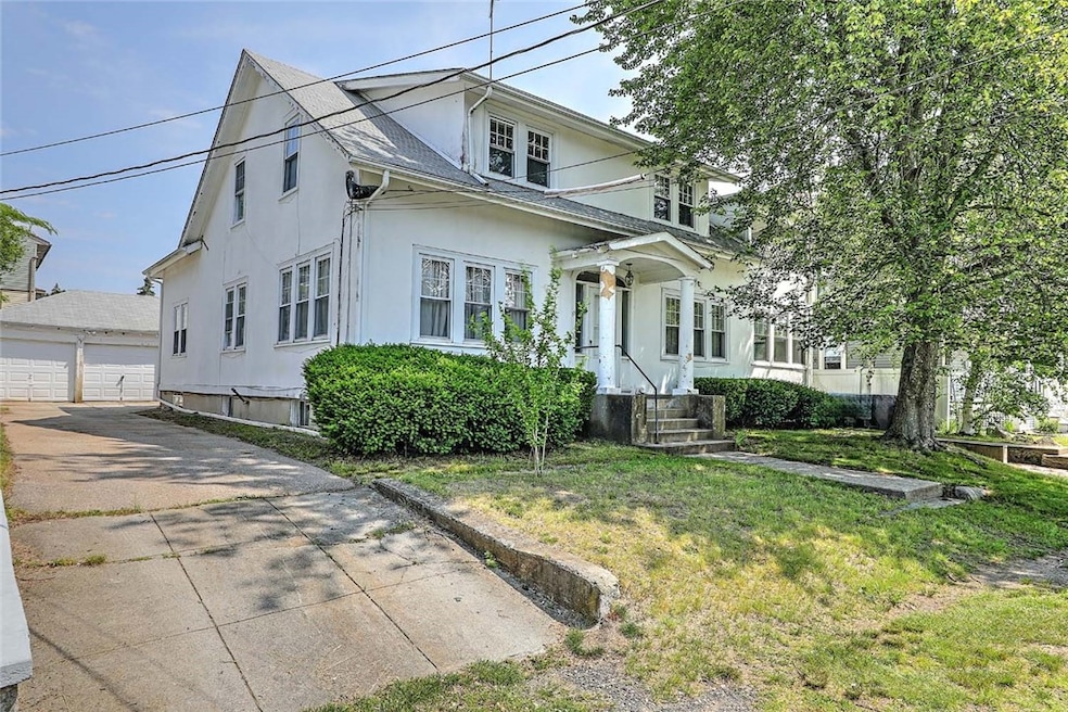


59 Colonial Ave Cranston, RI 02910
Eden Park Neighborhood
5
Beds
2
Baths
2,654
Sq Ft
6,800
Sq Ft Lot
Highlights
- Wood Flooring
- Balcony
- Bathtub with Shower
- Recreation Facilities
- 3 Car Detached Garage
- Storage Room
About This Home
As of August 2025Looking to build equity? This property offers a variety of options. It is currently a two unit but could be converted to a single family with an ADU or use the entire building as a single-family home. This Cottage Style home with second story dormers has over 2,650 square feet of living space. The first-floor unit has formal living and dining rooms, a sunroom, eat-in kitchen, full bath and three bedrooms. Up to the second level are two additional bedrooms, living room, a full bath, laundry and an eat-in kitchen with a balcony. There is a three-car garage for parking or combination workspace. This convenient location is just steps to Rolfe Square and an easy drive to Garden City and the interstate. Bring your design eye and imagine how you can transform this delightful home.
Last Agent to Sell the Property
Residential Properties Ltd. License #RES.0034320 Listed on: 06/19/2025
Property Details
Home Type
- Multi-Family
Est. Annual Taxes
- $5,684
Year Built
- Built in 1924
Parking
- 3 Car Detached Garage
- Driveway
Interior Spaces
- 2,654 Sq Ft Home
- 2-Story Property
- Fireplace Features Masonry
- Storage Room
- Utility Room
Kitchen
- Oven
- Range
- Dishwasher
Flooring
- Wood
- Carpet
Bedrooms and Bathrooms
- 5 Bedrooms
- 2 Full Bathrooms
- Bathtub with Shower
Laundry
- Dryer
- Washer
Unfinished Basement
- Basement Fills Entire Space Under The House
- Interior Basement Entry
Utilities
- No Cooling
- Heating System Uses Gas
- Baseboard Heating
- Heating System Uses Steam
- 100 Amp Service
- Gas Water Heater
Additional Features
- Balcony
- 6,800 Sq Ft Lot
Listing and Financial Details
- Tax Lot 1252
- Assessor Parcel Number 59COLONIALAVCRAN
Community Details
Overview
- 2 Units
- Eden Park Subdivision
Amenities
- Shops
- Restaurant
- Public Transportation
Recreation
- Recreation Facilities
Ownership History
Date
Name
Owned For
Owner Type
Purchase Details
Closed on
Aug 29, 2024
Sold by
Carty Virginia M
Bought by
Virginia M Carty Irt and Markovitz
Purchase Details
Closed on
Feb 23, 2017
Sold by
Carty Virginia M
Bought by
Virginia M Carty Lt 20
Similar Homes in the area
Create a Home Valuation Report for This Property
The Home Valuation Report is an in-depth analysis detailing your home's value as well as a comparison with similar homes in the area
Home Values in the Area
Average Home Value in this Area
Purchase History
| Date | Type | Sale Price | Title Company |
|---|---|---|---|
| Warranty Deed | -- | None Available | |
| Deed | -- | None Available | |
| Warranty Deed | -- | None Available | |
| Deed | -- | None Available | |
| Warranty Deed | -- | -- | |
| Warranty Deed | -- | -- |
Source: Public Records
Mortgage History
| Date | Status | Loan Amount | Loan Type |
|---|---|---|---|
| Previous Owner | $93,000 | No Value Available | |
| Previous Owner | $104,500 | No Value Available |
Source: Public Records
Property History
| Date | Event | Price | Change | Sq Ft Price |
|---|---|---|---|---|
| 08/28/2025 08/28/25 | Sold | $435,000 | +10.1% | $164 / Sq Ft |
| 06/24/2025 06/24/25 | Pending | -- | -- | -- |
| 06/19/2025 06/19/25 | For Sale | $395,000 | -- | $149 / Sq Ft |
Source: State-Wide MLS
Tax History Compared to Growth
Tax History
| Year | Tax Paid | Tax Assessment Tax Assessment Total Assessment is a certain percentage of the fair market value that is determined by local assessors to be the total taxable value of land and additions on the property. | Land | Improvement |
|---|---|---|---|---|
| 2024 | $5,684 | $417,600 | $110,400 | $307,200 |
| 2023 | $5,373 | $284,300 | $72,700 | $211,600 |
| 2022 | $5,262 | $284,300 | $72,700 | $211,600 |
| 2021 | $5,117 | $284,300 | $72,700 | $211,600 |
| 2020 | $5,168 | $248,800 | $69,200 | $179,600 |
| 2019 | $5,168 | $248,800 | $69,200 | $179,600 |
| 2018 | $5,048 | $248,800 | $69,200 | $179,600 |
| 2017 | $4,850 | $211,400 | $62,300 | $149,100 |
| 2016 | $4,746 | $211,400 | $62,300 | $149,100 |
| 2015 | $4,746 | $211,400 | $62,300 | $149,100 |
| 2014 | $3,997 | $198,500 | $62,300 | $136,200 |
Source: Public Records
Agents Affiliated with this Home
-
Jim DeRentis
Seller's Agent in 2025
Jim DeRentis
Residential Properties Ltd.
(401) 529-2188
2 in this area
486 Total Sales
-
Mike Caparco
Buyer's Agent in 2025
Mike Caparco
Keller Williams Coastal
(401) 338-6336
3 in this area
43 Total Sales
Map
Source: State-Wide MLS
MLS Number: 1388070
APN: CRAN-000009-000003-001252
Disclaimer: Certain information contained herein is derived from information provided by parties other than Homes.com. All information provided is deemed reliable, but is not guaranteed to be accurate and should be independently verified.
![]() IDX information is provided exclusively for personal, non-commercial use, and may not be used for any purpose other than to identify prospective properties consumers may be interested in purchasing. Information is deemed reliable but not guaranteed.
IDX information is provided exclusively for personal, non-commercial use, and may not be used for any purpose other than to identify prospective properties consumers may be interested in purchasing. Information is deemed reliable but not guaranteed.
Copyright © 2025 State-Wide MLS, Inc. All rights reserved.
Nearby Homes
- 64 Chestnut Ave
- 11 Branch Ave
- 101 Waldron Ave
- 483 Pontiac Ave
- 156 Potter St
- 75 Autumn St
- 14 Bryant Rd
- 109 Concord Ave
- 181 Grace St
- 58 Richard St
- 8 Somerset Rd
- 31 Myrtle Ave
- 216 Garden St
- 48 Wollaston St
- 199 Orchard St
- 21 Hemlock Ave
- 143 Auburn St
- 109 Fordson Ave
- 130 Fordson Ave Unit 3
- 16 Riverfarm Rd