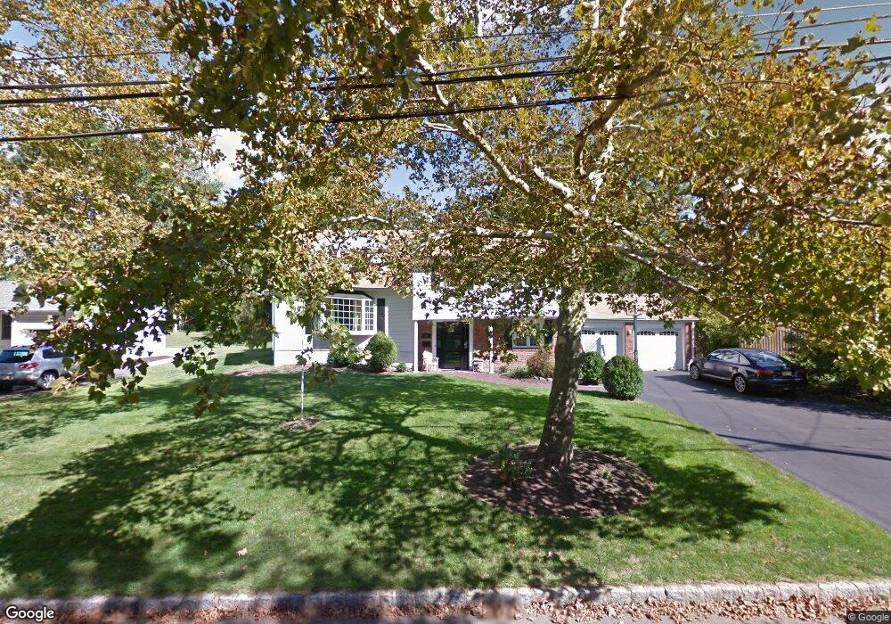
59 Glenbrook Rd New Providence, NJ 07974
Estimated Value: $1,173,000 - $1,424,000
--
Bed
--
Bath
2,738
Sq Ft
$474/Sq Ft
Est. Value
About This Home
This home is located at 59 Glenbrook Rd, New Providence, NJ 07974 and is currently estimated at $1,297,479, approximately $473 per square foot. 59 Glenbrook Rd is a home located in Union County with nearby schools including New Providence High School, The Academy of Our Lady of Peace, and Oak Knoll School of the Holy Child.
Ownership History
Date
Name
Owned For
Owner Type
Purchase Details
Closed on
Jul 10, 2009
Sold by
Marino Daniel and Marino Catherine
Bought by
Skotarczak Ronald and Skotarczak Erin
Current Estimated Value
Home Financials for this Owner
Home Financials are based on the most recent Mortgage that was taken out on this home.
Original Mortgage
$574,000
Outstanding Balance
$370,995
Interest Rate
5.12%
Mortgage Type
Purchase Money Mortgage
Estimated Equity
$926,484
Purchase Details
Closed on
Feb 3, 2000
Sold by
Mead Florence and Mead Marie C
Bought by
Marino Daniel and Marino Catherine
Home Financials for this Owner
Home Financials are based on the most recent Mortgage that was taken out on this home.
Original Mortgage
$316,000
Interest Rate
8.15%
Purchase Details
Closed on
Nov 18, 1999
Sold by
Mead Florence and Mead Marie C
Bought by
Mead Florence and Mead Marie C
Create a Home Valuation Report for This Property
The Home Valuation Report is an in-depth analysis detailing your home's value as well as a comparison with similar homes in the area
Home Values in the Area
Average Home Value in this Area
Purchase History
| Date | Buyer | Sale Price | Title Company |
|---|---|---|---|
| Skotarczak Ronald | $717,500 | Multiple | |
| Marino Daniel | $395,000 | -- | |
| Mead Florence | -- | -- |
Source: Public Records
Mortgage History
| Date | Status | Borrower | Loan Amount |
|---|---|---|---|
| Open | Skotarczak Ronald | $574,000 | |
| Previous Owner | Marino Daniel | $316,000 |
Source: Public Records
Tax History Compared to Growth
Tax History
| Year | Tax Paid | Tax Assessment Tax Assessment Total Assessment is a certain percentage of the fair market value that is determined by local assessors to be the total taxable value of land and additions on the property. | Land | Improvement |
|---|---|---|---|---|
| 2025 | $19,605 | $379,800 | $144,300 | $235,500 |
| 2024 | $17,815 | $379,800 | $144,300 | $235,500 |
| 2023 | $17,815 | $355,800 | $144,300 | $211,500 |
| 2022 | $17,569 | $355,800 | $144,300 | $211,500 |
| 2021 | $17,441 | $355,800 | $144,300 | $211,500 |
| 2020 | $17,434 | $355,800 | $144,300 | $211,500 |
| 2019 | $17,327 | $355,800 | $144,300 | $211,500 |
| 2018 | $17,239 | $355,800 | $144,300 | $211,500 |
| 2017 | $15,671 | $328,800 | $144,300 | $184,500 |
| 2016 | $15,450 | $328,800 | $144,300 | $184,500 |
| 2015 | $15,237 | $328,800 | $144,300 | $184,500 |
| 2014 | $15,006 | $328,800 | $144,300 | $184,500 |
Source: Public Records
Map
Nearby Homes
- 54 Badgley Dr
- 72 Central Ave
- 34 Grant Ave
- 106 Stoneridge Rd
- 1200 Springfield Ave Unit 1B
- 45 the Fellsway
- 19 Division Ave
- 197 Elkwood Ave
- 32 Marion Ave
- 16 Riverbend Ct
- 52 Greenwood Rd
- 340 Livingston Ave
- 282 South St
- 20 High St
- 100 Commonwealth Ave
- 29 Walton Ave
- 17 Valley View Ave
- 43 Passaic Ave
- 32 Charnwood Rd
- 283 Riveredge Dr
- 53 Glenbrook Rd
- 131 Brookside Dr
- 14 Midvale Dr
- 22 Midvale Dr
- 45 Glenbrook Rd
- 137 Brookside Dr
- 30 Midvale Dr
- 60 Glenbrook Rd
- 68 Glenbrook Rd
- 38 Midvale Dr
- 50 Glenbrook Rd
- 39 Glenbrook Rd
- 44 Midvale Dr
- 128 Brookside Dr
- 115 Brookside Dr
- 136 Brookside Dr
- 40 Glenbrook Rd
- 120 Brookside Dr
- 33 Glenbrook Rd
- 144 Brookside Dr