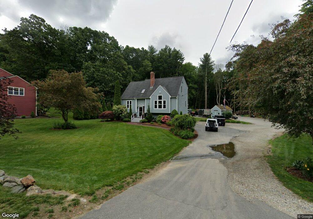
59 Mccracken Rd Millbury, MA 01527
Estimated Value: $579,000 - $680,000
4
Beds
2
Baths
1,763
Sq Ft
$348/Sq Ft
Est. Value
About This Home
This home is located at 59 Mccracken Rd, Millbury, MA 01527 and is currently estimated at $614,195, approximately $348 per square foot. 59 Mccracken Rd is a home located in Worcester County with nearby schools including Elmwood Street Elementary School, Raymond E. Shaw Elementary School, and Millbury Junior/Senior High School.
Ownership History
Date
Name
Owned For
Owner Type
Purchase Details
Closed on
Mar 4, 2005
Sold by
Ducharme Deborah A and Tarasiak Deborah A
Bought by
Tarasiak Deborah A
Current Estimated Value
Home Financials for this Owner
Home Financials are based on the most recent Mortgage that was taken out on this home.
Original Mortgage
$243,000
Outstanding Balance
$123,602
Interest Rate
5.66%
Mortgage Type
Purchase Money Mortgage
Estimated Equity
$490,593
Purchase Details
Closed on
May 9, 1994
Sold by
Zanadu Inc
Bought by
Tarasiak Paul and Ducharme Deborah
Create a Home Valuation Report for This Property
The Home Valuation Report is an in-depth analysis detailing your home's value as well as a comparison with similar homes in the area
Home Values in the Area
Average Home Value in this Area
Purchase History
| Date | Buyer | Sale Price | Title Company |
|---|---|---|---|
| Tarasiak Deborah A | -- | -- | |
| Tarasiak Paul | $134,990 | -- |
Source: Public Records
Mortgage History
| Date | Status | Borrower | Loan Amount |
|---|---|---|---|
| Open | Tarasiak Deborah A | $243,000 | |
| Previous Owner | Tarasiak Paul | $160,000 | |
| Previous Owner | Tarasiak Paul | $144,000 | |
| Previous Owner | Tarasiak Paul | $132,000 |
Source: Public Records
Tax History Compared to Growth
Tax History
| Year | Tax Paid | Tax Assessment Tax Assessment Total Assessment is a certain percentage of the fair market value that is determined by local assessors to be the total taxable value of land and additions on the property. | Land | Improvement |
|---|---|---|---|---|
| 2025 | $6,786 | $506,800 | $136,800 | $370,000 |
| 2024 | $6,233 | $471,100 | $126,700 | $344,400 |
| 2023 | $5,611 | $388,300 | $88,900 | $299,400 |
| 2022 | $5,442 | $362,800 | $88,900 | $273,900 |
| 2021 | $5,328 | $345,300 | $88,900 | $256,400 |
| 2020 | $5,159 | $336,500 | $88,900 | $247,600 |
| 2019 | $5,240 | $330,600 | $88,400 | $242,200 |
| 2018 | $6,590 | $314,600 | $88,400 | $226,200 |
| 2017 | $4,528 | $275,600 | $88,400 | $187,200 |
| 2016 | $4,426 | $268,900 | $88,400 | $180,500 |
| 2015 | $4,311 | $261,900 | $89,900 | $172,000 |
| 2014 | $4,246 | $248,300 | $93,900 | $154,400 |
Source: Public Records
Map
Nearby Homes
- 33 Tainter Hill Rd Unit 33B
- 5- 33 Tainter Hill Rd Unit 33A
- 5- 33 Tainter Hill Rd
- 557 SW Cutoff Unit 79
- 557 SW Cutoff Unit 107
- 557 SW Cutoff Unit 17
- 14 Auburn Rd
- 47 Washington St Unit 26
- 0 Auburn Rd
- 24 Upper Windbrook
- 3 Lower Windbrook Dr
- 2 Breezy Bend
- 15 Clearview Terrace Unit 68
- 90 Park Hill Ave
- 1295 Millbury St Unit B
- 52 Clearview Terrace Unit 39
- 55 Old Common Rd
- 40 River St
- 2 Camden Dr
- 32 Horne Way
- 57 Mccracken Rd
- 55 Mccracken Rd
- 55 Mccracken Rd
- Lot 71 Mccracken Rd
- 51 Mccracken Rd
- 45 Mccracken Rd
- 86 Mccracken Rd
- 58 Mccracken Rd
- 56 Mccracken Rd
- 65 Mccracken Rd
- 49 Mccracken Rd
- 50 Mccracken Rd
- 62 Mccracken Rd
- 52 Mccracken Rd
- 67 Mccracken Rd
- 68 Mccracken Rd
- 52 Dwinell Rd
- 46 Mccracken Rd
- 69 Mccracken Rd
- Lot B Dwinell Rd