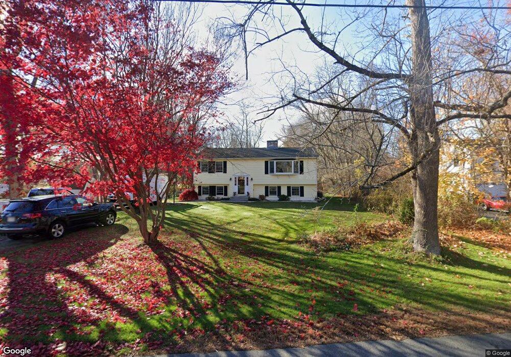
59 Mudnock Rd Salisbury, MA 01952
Estimated Value: $595,000 - $730,000
3
Beds
2
Baths
2,756
Sq Ft
$240/Sq Ft
Est. Value
About This Home
This home is located at 59 Mudnock Rd, Salisbury, MA 01952 and is currently estimated at $660,192, approximately $239 per square foot. 59 Mudnock Rd is a home located in Essex County with nearby schools including Triton Regional High School.
Ownership History
Date
Name
Owned For
Owner Type
Purchase Details
Closed on
Oct 17, 2024
Sold by
Kosakowski Linda J and Kosakowski Ray W
Bought by
Kosakowski Nt and Kosakowski
Current Estimated Value
Purchase Details
Closed on
Sep 30, 1994
Sold by
Chrestensen Arthur and Chrestensen F
Bought by
Smith Martin F
Home Financials for this Owner
Home Financials are based on the most recent Mortgage that was taken out on this home.
Original Mortgage
$85,000
Interest Rate
8.5%
Mortgage Type
Purchase Money Mortgage
Create a Home Valuation Report for This Property
The Home Valuation Report is an in-depth analysis detailing your home's value as well as a comparison with similar homes in the area
Home Values in the Area
Average Home Value in this Area
Purchase History
| Date | Buyer | Sale Price | Title Company |
|---|---|---|---|
| Kosakowski Nt | -- | None Available | |
| Kosakowski Nt | -- | None Available | |
| Smith Martin F | $107,500 | -- | |
| Smith Martin F | $107,500 | -- |
Source: Public Records
Mortgage History
| Date | Status | Borrower | Loan Amount |
|---|---|---|---|
| Previous Owner | Smith Martin F | $99,312 | |
| Previous Owner | Smith Martin F | $107,300 | |
| Previous Owner | Smith Martin F | $15,000 | |
| Previous Owner | Smith Martin F | $85,000 |
Source: Public Records
Tax History
| Year | Tax Paid | Tax Assessment Tax Assessment Total Assessment is a certain percentage of the fair market value that is determined by local assessors to be the total taxable value of land and additions on the property. | Land | Improvement |
|---|---|---|---|---|
| 2025 | $5,624 | $557,900 | $207,500 | $350,400 |
| 2024 | $5,289 | $506,100 | $196,600 | $309,500 |
| 2023 | $5,054 | $468,000 | $196,600 | $271,400 |
| 2022 | $4,836 | $434,100 | $174,800 | $259,300 |
| 2021 | $4,699 | $417,300 | $174,800 | $242,500 |
| 2020 | $4,458 | $389,000 | $183,600 | $205,400 |
| 2019 | $4,291 | $361,800 | $174,800 | $187,000 |
| 2018 | $4,114 | $349,200 | $164,000 | $185,200 |
| 2017 | $4,089 | $343,000 | $156,300 | $186,700 |
| 2016 | $3,702 | $317,200 | $139,100 | $178,100 |
| 2015 | $3,603 | $306,600 | $134,400 | $172,200 |
Source: Public Records
Map
Nearby Homes
- 11 Mudnock Rd
- 46 True Rd
- 2 True Rd
- 9 Meadowview Ln Unit A
- 14 Meadowview Ln Unit B
- 16 Meadowview Ln Unit B
- 48 Beach Rd Unit C
- 3 Lighthouse Cir Unit A
- 2 Heron Way Unit B
- 86 Ferry Rd
- 1 Learned Ln
- 8 Sweet Apple Tree Ln
- 191 Elm St
- 57 Baker Rd
- 10 Friedenfels St
- 157 Bridge Rd
- 42 Kendell Ln
- 1 Jefferson St
- 10 Union Place
- 154 Lafayette Rd
- 61 Mudnock Rd
- 57 Mudnock Rd
- 55 Mudnock Rd
- 56 Mudnock Rd
- 54 Mudnock Rd
- 63 Mudnock Rd
- 53 Mudnock Rd
- 10 Ferry Lots Ln
- 52 Mudnock Rd
- 12 Ferry Lots Ln
- 62 Mudnock Rd
- 58 Mudnock Rd
- 50 Mudnock Rd
- 2 Ferry Rd Unit B
- 2 Ferry Rd Unit B (Left)
- 2 Ferry Rd Unit A (Right)
- 2 Ferry Rd
- 2 Ferry Lots Ln
- 4 Ferry Lots Ln
- 51 Mudnock Rd
Your Personal Tour Guide
Ask me questions while you tour the home.