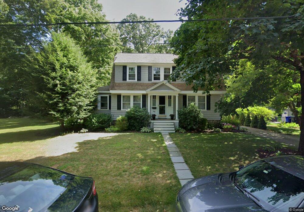
59 Oakland Ave Hanover, MA 02339
Estimated Value: $773,000 - $884,000
3
Beds
2
Baths
1,556
Sq Ft
$527/Sq Ft
Est. Value
About This Home
This home is located at 59 Oakland Ave, Hanover, MA 02339 and is currently estimated at $820,143, approximately $527 per square foot. 59 Oakland Ave is a home located in Plymouth County with nearby schools including Hanover High School, Cadence Academy Preschool - Hanover, and Cardinal Cushing Centers.
Ownership History
Date
Name
Owned For
Owner Type
Purchase Details
Closed on
Apr 2, 1998
Sold by
Carey Douglas C and Carey Deirdre A
Bought by
Champagne Jeanne M and Hibbard Robert P
Current Estimated Value
Purchase Details
Closed on
Apr 1, 1998
Sold by
Carey Douglas C and Carey Deirdre A
Bought by
Champagne Jeanne M and Hibbard Robert P
Purchase Details
Closed on
Jul 10, 1989
Sold by
Sidman Charles S
Bought by
Carey Douglas C
Create a Home Valuation Report for This Property
The Home Valuation Report is an in-depth analysis detailing your home's value as well as a comparison with similar homes in the area
Home Values in the Area
Average Home Value in this Area
Purchase History
| Date | Buyer | Sale Price | Title Company |
|---|---|---|---|
| Champagne Jeanne M | $219,500 | -- | |
| Champagne Jeanne M | $219,500 | -- | |
| Carey Douglas C | $187,500 | -- |
Source: Public Records
Mortgage History
| Date | Status | Borrower | Loan Amount |
|---|---|---|---|
| Open | Carey Douglas C | $80,000 | |
| Open | Carey Douglas C | $216,100 | |
| Closed | Carey Douglas C | $50,000 |
Source: Public Records
Tax History Compared to Growth
Tax History
| Year | Tax Paid | Tax Assessment Tax Assessment Total Assessment is a certain percentage of the fair market value that is determined by local assessors to be the total taxable value of land and additions on the property. | Land | Improvement |
|---|---|---|---|---|
| 2025 | $7,835 | $634,400 | $280,500 | $353,900 |
| 2024 | $7,707 | $600,200 | $280,500 | $319,700 |
| 2023 | $7,054 | $522,900 | $255,200 | $267,700 |
| 2022 | $7,338 | $481,200 | $255,200 | $226,000 |
| 2021 | $7,197 | $440,700 | $232,100 | $208,600 |
| 2020 | $7,039 | $431,600 | $232,100 | $199,500 |
| 2019 | $6,874 | $418,900 | $232,100 | $186,800 |
| 2018 | $6,525 | $400,800 | $232,100 | $168,700 |
| 2017 | $6,145 | $372,000 | $215,900 | $156,100 |
| 2016 | $5,884 | $349,000 | $196,300 | $152,700 |
| 2015 | $5,636 | $349,000 | $196,300 | $152,700 |
Source: Public Records
Map
Nearby Homes
- 20 Meadow Brook Rd
- 28 Old Shipyard Ln
- 26 Church St
- 186 Elm St
- 180 Elm St
- 55 Shipyard Ln
- 14 Longwood Ln Unit 14
- 133 Brigantine Cir
- 172 Washington St
- 265 Silver St
- 46 Lorna Ave
- 114 Graham Hill Dr
- 37 Tara Dr
- 218 Schoosett St
- 10 Shrine Rd
- 261 Washington St
- 7 Farmside Dr
- 107 Wildcat Ln
- 250 Center St
- 51 Cervelli Farm Dr
- 53 Oakland Ave
- 69 Oakland Ave
- 64 Oakland Ave
- 45 Oakland Ave
- 48 Oakland Ave
- 15 Barstow Ave
- 78 Oakland Ave
- 40 Oakland Ave
- 265 Washington St
- 86 Oakland Ave
- 87 Broadway
- 275 Washington St
- 101 Broadway
- 32 Oakland Ave
- 107 Broadway
- 257 Washington St Unit 3
- 243 Washington St
- 287 Washington St
- 94 Oakland Ave
- 123 Broadway