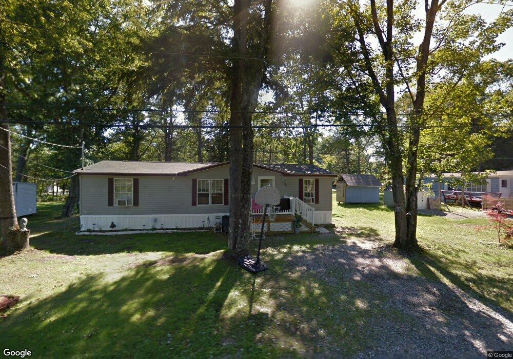
59 Old Post Ln Sanford, ME 04073
South Sanford NeighborhoodEstimated Value: $446,000 - $478,000
4
Beds
2
Baths
1,896
Sq Ft
$243/Sq Ft
Est. Value
About This Home
This home is located at 59 Old Post Ln, Sanford, ME 04073 and is currently estimated at $460,325, approximately $242 per square foot. 59 Old Post Ln is a home located in York County with nearby schools including Sanford Christian Academy and St Thomas Consolidated School.
Ownership History
Date
Name
Owned For
Owner Type
Purchase Details
Closed on
Oct 22, 2019
Sold by
Bridgeo Sherrill M
Bought by
Sherrill Bridgeo Rt and Bridgeo
Current Estimated Value
Purchase Details
Closed on
Aug 2, 2011
Sold by
Berube Jennifer J
Bought by
Bridgeo Sherrill M and Bridgeo Walter W
Purchase Details
Closed on
Jan 5, 2006
Sold by
Berube Scott C
Bought by
Berube Jennifer J
Create a Home Valuation Report for This Property
The Home Valuation Report is an in-depth analysis detailing your home's value as well as a comparison with similar homes in the area
Home Values in the Area
Average Home Value in this Area
Purchase History
| Date | Buyer | Sale Price | Title Company |
|---|---|---|---|
| Sherrill Bridgeo Rt | -- | -- | |
| Bridgeo Sherrill M | -- | -- | |
| Bridgeo Sherrill M | -- | -- | |
| Berube Jennifer J | -- | -- | |
| Berube Jennifer J | -- | -- |
Source: Public Records
Mortgage History
| Date | Status | Borrower | Loan Amount |
|---|---|---|---|
| Previous Owner | Berube Jennifer J | $160,000 |
Source: Public Records
Tax History Compared to Growth
Tax History
| Year | Tax Paid | Tax Assessment Tax Assessment Total Assessment is a certain percentage of the fair market value that is determined by local assessors to be the total taxable value of land and additions on the property. | Land | Improvement |
|---|---|---|---|---|
| 2025 | $5,239 | $306,400 | $52,600 | $253,800 |
| 2024 | $4,945 | $306,400 | $52,600 | $253,800 |
| 2023 | $4,601 | $303,900 | $52,600 | $251,300 |
| 2022 | $4,498 | $303,900 | $52,600 | $251,300 |
| 2021 | $4,509 | $248,000 | $52,600 | $195,400 |
| 2020 | $4,328 | $214,700 | $52,600 | $162,100 |
| 2019 | $4,163 | $201,100 | $52,600 | $148,500 |
| 2018 | $3,557 | $193,500 | $52,600 | $140,900 |
| 2017 | $3,986 | $192,200 | $52,600 | $139,600 |
| 2016 | $4,025 | $177,000 | $52,500 | $124,500 |
| 2015 | $4,170 | $189,200 | $61,600 | $127,600 |
| 2014 | $4,099 | $189,600 | $61,900 | $127,700 |
| 2013 | -- | $189,700 | $61,900 | $127,800 |
Source: Public Records
Map
Nearby Homes
- 12 Alice St
- 18 Oak Ridge Rd
- 392 High St
- 8 Stoney Brook Rd
- 13 Rachel Dr
- 9 Commodore Dr
- 6 Commodore Dr
- 5 Bedrock Dr Unit 5
- 1 Bedrock Dr Unit 1
- 2 Bedrock Dr Unit 2
- 8 Rock Pond Rd Unit 8
- 7 Raymond St
- 2 Oak Forest St
- 0 Pheasant Ln Unit 1633461
- 0 Pheasant Ln Unit 1611370
- 8 Hummingbird Ln
- 11 Wilson St
- 13 Timothy Ln
- 87 Farview Dr
- TBD Pheasant Ln