NOT LISTED FOR SALE

590 W Elusive Dr Unit 11 Payson, AZ 85541

Estimated Value: $35,418 - $377,000

0.82 Acre
$251,474 Price per Acre
35,719 Sq Ft Lot

Last Sold March 07, 2023

Last sale price $30,000

Est. 587% increase in value since last sale

Current estimated payment $1,133/month

81 Days on Market

Highlights

  • Mountain View
  • No HOA
  • Property is near a preserve or public land
  • Mountainous Lot
  • Cul-De-Sac

About This Lot

As of March 2023

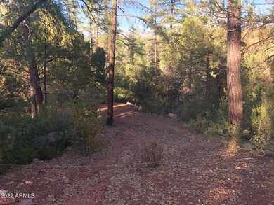
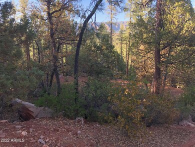
This lot is raw land that is connected to Tonto Forest and also connected to Lot 10 which has the pad in place.

Last Agent to Sell the Property

Charisse LeDe

Delex Realty License #SA560206000 Listed on: 01/14/2023

Delex Realty

Last Buyer's Agent

Audrey Hogue

My Home Group Real Estate License #SA652488000

My Home Group Real Estate

Property Details

Property Type

  • Land

Est. Annual Taxes

  • $533

Lot Details

  • 0.82 Acre Lot
  • Cul-De-Sac
  • Mountainous Lot
  • Additional Parcels

Property Views

  • Mountain Views

Community Details

  • No Home Owners Association
  • Elusive Acres Subdivision
  • Property is near a preserve or public land

Listing and Financial Details

  • Tax Lot 11
  • Assessor Parcel Number 302-13-031

Property Details

Property Type

Land

Est. Annual Taxes

$533

Lot Details

0

Listing Details

  • Cross Street: HWY 260 & Fire Control Road
  • Legal Info Range: 10E
  • Property Type: Land
  • Topography: Mountainous
  • Zoning: res
  • Tax Year: 2021
  • Lot Size Acres: 0.82
  • Road Surface Type: Gravel
  • Subdivision Name: ELUSIVE ACRES
  • View:Mountain View(s): Yes
  • Special Features: None
  • Property Sub Type: LotsLands

Exterior Features

  • Fencing: None
  • Lot Features: Cul-De-Sac, Borders Pres/Pub Lnd
  • View: Mountain(s)
  • Disclosures: None
  • Other Structures: None

Utilities

  • Electric: APS
  • Water Source: Hauled Water

Condo/Co-op/Association

  • Association: No

Schools

  • Junior High Dist: Payson Unified District

Lot Info

  • Lot Size: 00
  • Lot Size Sq Ft: 35873.0
  • Additional Parcels: Yes
  • Parcel #: 302-13-031
  • ResoLotSizeUnits: Acres

Tax Info

  • Tax Annual Amount: 533.0
  • Tax Book Number: 302.00
  • Tax Lot: 11
  • Tax Map Number: 13.00

Ownership History

Date Name Owned For Owner Type

Purchase Details

Closed on
Sep 13, 2018
Sold by
Stolze Robert and Ward Timothy
Bought by
Ward Timothy S
Current Estimated Value
$206,209
Source: Public Records

Range of Values:

--
Value Increase
--
Percent Increase
--
Adjusted for Inflation
Collateral Analytics

Collateral Analytics Collateral Analytics AVMs (Automated Valuation Model) employ a number of statistical approaches combined with neighborhood-specific comparable selection guarantees the most up-to-date and precise valuations.

Not Available

Collateral Analytics does not have data for the current month. Please view the chart for historical values.

ICE

ICE Mortgage Technology ICE Mortgage Technology’s AVM (Automated Valuation Model) is a state-of-the-art online residential property valuation tool that provides a quick and accurate estimate of the value of almost any home in the U.S.

Not Available

ICE Mortgage Technology does not have data for the current month. Please view the chart for historical values.

First American

First American First American Data & Analytics’ next-generation AVM combines unrivaled data assets with a blended ensemble of valuation models to produce highly accurate, reliable valuations you can trust.

Not Available

First American does not have data for the current month. Please view the chart for historical values.

Quantarium

Quantarium Quantarium’s valuation service, repeatedly proven the industry’s most accurate and comprehensive, is supercharged with a self-learning and auto-tuning AI engine that continually becomes smarter and more accurate as it processes daily inputs from the industry’s leading RE data lake.

Not Available

Quantarium does not have data for the current month. Please view the chart for historical values.

Average Value
Not Available
List Price
Sold Price
Create a Home Valuation Report for This Property
The Home Valuation Report is an in-depth analysis detailing your home's value as well as a comparison with similar homes in the area

Home Values in the Area

Source: Public Records

Average Home Value in this Area


Source: Public Records

Purchase History

Date Buyer Sale Price Title Company
Ward Timothy S $15,000 Pioneer Title Agency Inc
Source: Public Records

Property History

Date Event Price List to Sale Price per Sq Ft
03/07/2023 03/07/23 Sold $30,000 -21.1% --
02/20/2023 02/20/23 Pending -- -- --
01/14/2023 01/14/23 For Sale $38,000 0.0% --
01/14/2023 01/14/23 Price Changed $38,000 +26.7% --
01/12/2023 01/12/23 Off Market $30,000 -- --
12/01/2022 12/01/22 For Sale $80,000 -- --
Source: Arizona Regional Multiple Listing Service (ARMLS)

Tax History Compared to Growth

Source: Public Records

Tax History

Year Tax Paid Tax Assessment Tax Assessment Total Assessment is a certain percentage of the fair market value that is determined by local assessors to be the total taxable value of land and additions on the property. Land Improvement
2025 $575 -- -- --
2024 $575 $10,764 $6,447 $4,317
2023 $575 $9,249 $5,137 $4,112
2022 $551 $9,053 $5,137 $3,916
2021 $533 $8,866 $5,137 $3,729
2020 $520 $0 $0 $0
2019 $499 $0 $0 $0
2018 $475 $0 $0 $0
2017 $464 $0 $0 $0
2016 $453 $0 $0 $0
2015 $459 $0 $0 $0
Source: Public Records

Agents Affiliated with this Home

  • Section Image
  • Section Image
See All Agents

Map

Source: Arizona Regional Multiple Listing Service (ARMLS)

MLS Number: 6495406

Arizona Regional Multiple Listing Service (ARMLS)

APN: 302-13-031