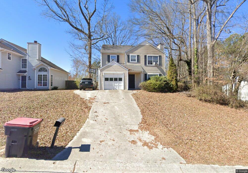
5900 Brookside Dr SE Mableton, GA 30126
Estimated Value: $298,000 - $333,000
3
Beds
3
Baths
1,688
Sq Ft
$187/Sq Ft
Est. Value
About This Home
This home is located at 5900 Brookside Dr SE, Mableton, GA 30126 and is currently estimated at $314,837, approximately $186 per square foot. 5900 Brookside Dr SE is a home located in Cobb County with nearby schools including Clay-Harmony Leland Elementary School, Lindley Middle School, and Pebblebrook High School.
Ownership History
Date
Name
Owned For
Owner Type
Purchase Details
Closed on
Mar 18, 2011
Sold by
Us Bk National Assn
Bought by
Ayoub Danny
Current Estimated Value
Purchase Details
Closed on
Nov 2, 2010
Sold by
Hill Quran L
Bought by
Us Bk National Assn
Purchase Details
Closed on
Jun 23, 2000
Sold by
Oliver E E
Bought by
Allen Christopher L
Home Financials for this Owner
Home Financials are based on the most recent Mortgage that was taken out on this home.
Original Mortgage
$111,180
Interest Rate
8.12%
Mortgage Type
VA
Create a Home Valuation Report for This Property
The Home Valuation Report is an in-depth analysis detailing your home's value as well as a comparison with similar homes in the area
Home Values in the Area
Average Home Value in this Area
Purchase History
| Date | Buyer | Sale Price | Title Company |
|---|---|---|---|
| Ayoub Danny | $49,000 | -- | |
| Us Bk National Assn | $55,038 | -- | |
| Allen Christopher L | $109,000 | -- |
Source: Public Records
Mortgage History
| Date | Status | Borrower | Loan Amount |
|---|---|---|---|
| Previous Owner | Allen Christopher L | $111,180 |
Source: Public Records
Tax History Compared to Growth
Tax History
| Year | Tax Paid | Tax Assessment Tax Assessment Total Assessment is a certain percentage of the fair market value that is determined by local assessors to be the total taxable value of land and additions on the property. | Land | Improvement |
|---|---|---|---|---|
| 2024 | $3,474 | $115,232 | $26,000 | $89,232 |
| 2023 | $2,450 | $81,276 | $24,000 | $57,276 |
| 2022 | $2,467 | $81,276 | $24,000 | $57,276 |
| 2021 | $1,836 | $60,500 | $22,000 | $38,500 |
| 2020 | $1,533 | $50,500 | $12,000 | $38,500 |
| 2019 | $1,533 | $50,500 | $12,000 | $38,500 |
| 2018 | $1,151 | $37,928 | $4,000 | $33,928 |
| 2017 | $1,090 | $37,928 | $4,000 | $33,928 |
| 2016 | $904 | $31,448 | $4,000 | $27,448 |
| 2015 | $926 | $31,448 | $4,000 | $27,448 |
| 2014 | $677 | $22,792 | $0 | $0 |
Source: Public Records
Map
Nearby Homes
- 1470 Riverline Ct SE
- 5937 Sharp Dr SE
- 6018 Oakdale Rd SE
- 6304 Brookwater View SE
- 1444 Ridgebend Way SE
- 6038 Mayfield Way SE
- 1565 Oakdale Bluffs Dr SE
- 1629 Watercress Ct SE
- 1507 Justine Way SE
- 6616 Brooklyn Ct SE
- 5977 Rosie Ln SE
- 6213 Indian Wood Cir SE
- 6148 Indian Wood Cir SE
- 6255 Oakdale Rd SE
- 6207 Indian Wood Cir SE
- 5975 Haddon Place SE
- 5975 Haddon Place
- 6254 Village Arbor Ln
- 5902 Brookside Dr SE
- 5892 Brookside Dr SE
- 5998 Brookside Ln SE
- 5904 Brookside Dr SE
- 6000 Brookside Ln SE
- 5965 Brookside Dr SE
- 5967 Brookside Dr SE
- 5903 Brookside Dr SE
- 5899 Brookside Dr SE
- 5890 Brookside Dr SE
- 5969 Brookside Dr SE
- 5905 Brookside Dr SE
- 5897 Brookside Dr SE
- 6002 Brookside Ln SE
- 5907 Brookside Dr SE
- 5907 Brookside Dr SE Unit 5
- 5888 Brookside Dr SE
- 5895 Brookside Dr SE
- 5995 Brookside Ln SE
- 1458 Brookline Ct SE