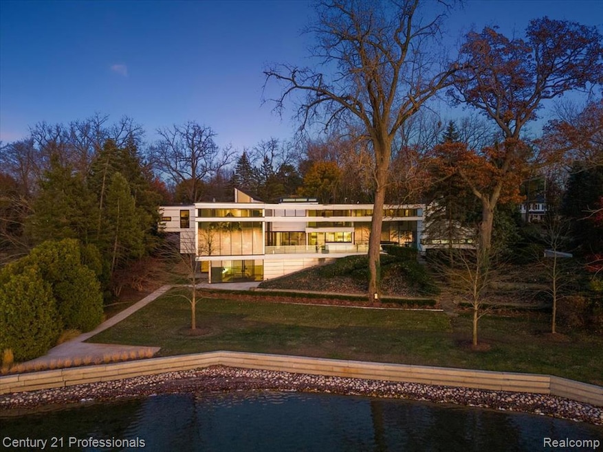
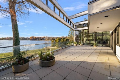
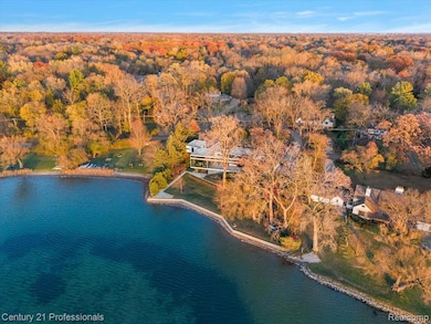
5904 Wing Lake Rd Bloomfield Hills, MI 48301
Estimated Value: $1,512,000 - $1,962,658
3
Beds
5
Baths
5,909
Sq Ft
$294/Sq Ft
Est. Value
About This Home
This home is located at 5904 Wing Lake Rd, Bloomfield Hills, MI 48301 and is currently estimated at $1,737,329, approximately $294 per square foot. 5904 Wing Lake Rd is a home located in Oakland County with nearby schools including Conant Elementary School, South Hills Middle School, and Bloomfield Hills High School.
Ownership History
Date
Name
Owned For
Owner Type
Purchase Details
Closed on
Aug 27, 2008
Sold by
Myers Irene M and William D Myers Trust
Bought by
Zekelman Alan
Current Estimated Value
Purchase Details
Closed on
Feb 27, 2008
Sold by
Myers Irene M
Bought by
Myers Irene M and Irene M Myers Trust
Purchase Details
Closed on
Sep 28, 2007
Sold by
Myers Irene M and Estate Of William Darryl Myers
Bought by
Myers Irene M and William D Myers Trust
Create a Home Valuation Report for This Property
The Home Valuation Report is an in-depth analysis detailing your home's value as well as a comparison with similar homes in the area
Home Values in the Area
Average Home Value in this Area
Purchase History
Date | Buyer | Sale Price | Title Company |
---|---|---|---|
Zekelman Alan | -- | None Available | |
Zekelman Alan | -- | Metropolitan Title Company | |
Myers Irene M | -- | None Available | |
Myers Irene M | -- | None Available |
Source: Public Records
Mortgage History
Date | Status | Borrower | Loan Amount |
---|---|---|---|
Previous Owner | Myers William D | $1,950,000 |
Source: Public Records
Tax History Compared to Growth
Tax History
Year | Tax Paid | Tax Assessment Tax Assessment Total Assessment is a certain percentage of the fair market value that is determined by local assessors to be the total taxable value of land and additions on the property. | Land | Improvement |
---|---|---|---|---|
2024 | $25,342 | $1,928,190 | $0 | $0 |
2023 | $24,168 | $1,720,850 | $0 | $0 |
2022 | $45,290 | $1,470,100 | $0 | $0 |
2021 | $44,099 | $1,396,290 | $0 | $0 |
2020 | $21,301 | $1,454,250 | $0 | $0 |
2019 | $41,390 | $1,340,450 | $0 | $0 |
2018 | $40,579 | $1,242,970 | $0 | $0 |
2017 | $39,946 | $1,196,800 | $0 | $0 |
2016 | $39,821 | $1,076,960 | $0 | $0 |
2015 | -- | $975,430 | $0 | $0 |
2014 | -- | $861,910 | $0 | $0 |
2011 | -- | $757,820 | $0 | $0 |
Source: Public Records
Map
Nearby Homes
- 5575 Forman Dr
- 4343 Quarton Rd
- 6391 Wing Lake Rd
- 4200 Surrey Cross
- 4115 Orchard Way
- 560 Billingsgate Ct Unit 30
- 1360 Trailwood Path Unit 76
- 1760 Trailwood Path
- 5908 Burnham Rd
- 100 Billingsgate Ct Unit 1
- 5799 Blandford Ct
- 5626 Shadow Ln
- 4456 W Maple Rd
- 1194 Rolling Hills Dr
- 6220 Thorncrest Dr
- 5340 Franklin Rd
- 1683 Mark Hopkins Rd
- 1651 Hoit Tower Dr
- 6701 Franklin Rd
- 5611 Priory Ln
- 5950 Wing Lake Rd
- 5885 Wing Lake Rd
- 5855 Wingcroft Ct
- 5955 Wing Lake Rd
- 5964 Wing Lake Rd
- 5965 Wing Lake Rd
- 5875 Wingcroft Ct
- 5865 Wingcroft Ct
- 5841 Wing Lake Rd
- 4260 Sandy Ln
- 5970 Wing Lake Rd
- 4261 Carey Ln
- 5975 Wing Lake Rd
- 4250 Sandy Ln
- 5990 Wing Lake Rd
- 6024 Worlington Rd
- 4247 Carey Ln
- 6005 Wing Lake Rd
- 5815 Wing Lake Rd
- 4274 Carey Ln