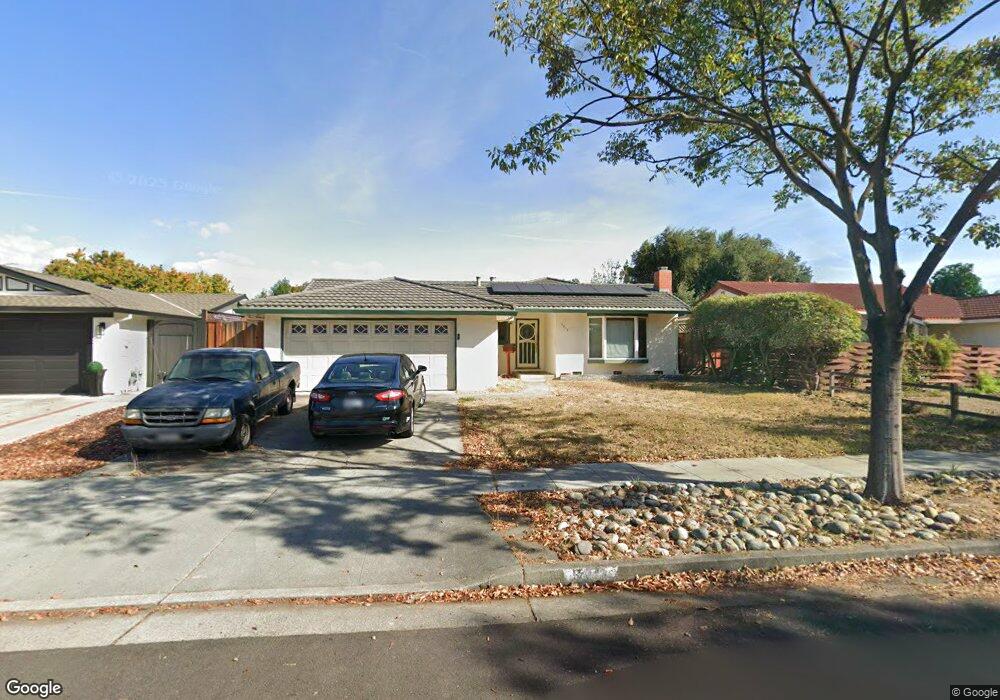
5912 Mohawk Dr San Jose, CA 95123
Shawnee NeighborhoodEstimated Value: $1,282,000 - $1,374,000
4
Beds
2
Baths
1,345
Sq Ft
$975/Sq Ft
Est. Value
About This Home
This home is located at 5912 Mohawk Dr, San Jose, CA 95123 and is currently estimated at $1,310,965, approximately $974 per square foot. 5912 Mohawk Dr is a home located in Santa Clara County with nearby schools including Frost (Earl) Elementary School, Herman (Leonard) Intermediate School, and Santa Teresa High School.
Ownership History
Date
Name
Owned For
Owner Type
Purchase Details
Closed on
Aug 14, 2003
Sold by
Baker Colleen P
Bought by
Baker Colleen P and Colleen P Baker Trust
Current Estimated Value
Home Financials for this Owner
Home Financials are based on the most recent Mortgage that was taken out on this home.
Original Mortgage
$364,000
Interest Rate
5.37%
Mortgage Type
Purchase Money Mortgage
Purchase Details
Closed on
Jun 25, 2001
Sold by
Baker Colleen and Baker Colleen P
Bought by
Baker Colleen P and Colleen P Baker Trust
Create a Home Valuation Report for This Property
The Home Valuation Report is an in-depth analysis detailing your home's value as well as a comparison with similar homes in the area
Home Values in the Area
Average Home Value in this Area
Purchase History
| Date | Buyer | Sale Price | Title Company |
|---|---|---|---|
| Baker Colleen P | -- | Old Republic Title Company | |
| Baker Colleen P | -- | Old Republic Title Company | |
| Baker Colleen P | -- | -- |
Source: Public Records
Mortgage History
| Date | Status | Borrower | Loan Amount |
|---|---|---|---|
| Closed | Baker Colleen P | $364,000 |
Source: Public Records
Tax History
| Year | Tax Paid | Tax Assessment Tax Assessment Total Assessment is a certain percentage of the fair market value that is determined by local assessors to be the total taxable value of land and additions on the property. | Land | Improvement |
|---|---|---|---|---|
| 2025 | $4,054 | $203,693 | $46,834 | $156,859 |
| 2024 | $4,054 | $199,700 | $45,916 | $153,784 |
| 2023 | $3,949 | $195,785 | $45,016 | $150,769 |
| 2022 | $3,909 | $191,947 | $44,134 | $147,813 |
| 2021 | $3,791 | $188,184 | $43,269 | $144,915 |
| 2020 | $3,667 | $186,256 | $42,826 | $143,430 |
| 2019 | $3,559 | $182,605 | $41,987 | $140,618 |
| 2018 | $3,509 | $179,025 | $41,164 | $137,861 |
| 2017 | $3,453 | $175,515 | $40,357 | $135,158 |
| 2016 | $3,289 | $172,074 | $39,566 | $132,508 |
| 2015 | $3,215 | $169,490 | $38,972 | $130,518 |
| 2014 | $2,660 | $166,171 | $38,209 | $127,962 |
Source: Public Records
Map
Nearby Homes
- 488 Tuscarora Dr
- 559 Yurok Cir
- 5711 Hillbright Cir
- 476 Safari Dr
- 440 Ariel Dr
- 619 Pima Dr
- 5798 Ribchester Ct
- 6020 Colter Place
- 5806 Blossom Ave
- 6230 Current Dr
- 6225 Gunter Way
- 6217 Hopi Ct
- 5830 Zileman Ct
- 6209 Hopi Ct
- 5810 Zileman Dr
- 6221 Glider Dr
- 616 Brenda Lee Dr
- 5888 Lean Way
- 5705 Chesbro Ave
- 294 Tradewinds Dr Unit 4
Your Personal Tour Guide
Ask me questions while you tour the home.