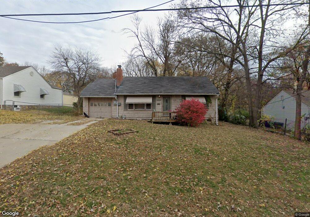
5939 Stearns St Shawnee, KS 66203
Estimated Value: $240,000 - $261,000
2
Beds
1
Bath
768
Sq Ft
$328/Sq Ft
Est. Value
About This Home
This home is located at 5939 Stearns St, Shawnee, KS 66203 and is currently estimated at $252,211, approximately $328 per square foot. 5939 Stearns St is a home located in Johnson County with nearby schools including Merriam Park Elementary School, Hocker Grove Middle School, and Shawnee Mission North High School.
Ownership History
Date
Name
Owned For
Owner Type
Purchase Details
Closed on
May 23, 2024
Sold by
Grahovac Nancy L and Colburn Nancy L
Bought by
Shortstop Properties Llc
Current Estimated Value
Home Financials for this Owner
Home Financials are based on the most recent Mortgage that was taken out on this home.
Original Mortgage
$135,000
Outstanding Balance
$100,731
Interest Rate
6.88%
Mortgage Type
New Conventional
Estimated Equity
$151,480
Create a Home Valuation Report for This Property
The Home Valuation Report is an in-depth analysis detailing your home's value as well as a comparison with similar homes in the area
Home Values in the Area
Average Home Value in this Area
Purchase History
| Date | Buyer | Sale Price | Title Company |
|---|---|---|---|
| Shortstop Properties Llc | -- | Accurate Title |
Source: Public Records
Mortgage History
| Date | Status | Borrower | Loan Amount |
|---|---|---|---|
| Open | Shortstop Properties Llc | $135,000 |
Source: Public Records
Tax History Compared to Growth
Tax History
| Year | Tax Paid | Tax Assessment Tax Assessment Total Assessment is a certain percentage of the fair market value that is determined by local assessors to be the total taxable value of land and additions on the property. | Land | Improvement |
|---|---|---|---|---|
| 2024 | $2,536 | $24,334 | $5,822 | $18,512 |
| 2023 | $2,522 | $23,609 | $5,822 | $17,787 |
| 2022 | $2,242 | $20,918 | $5,291 | $15,627 |
| 2021 | $2,087 | $18,101 | $4,598 | $13,503 |
| 2020 | $1,907 | $16,307 | $4,183 | $12,124 |
| 2019 | $1,891 | $16,042 | $3,489 | $12,553 |
| 2018 | $1,719 | $14,617 | $3,165 | $11,452 |
| 2017 | $1,694 | $14,180 | $3,165 | $11,015 |
| 2016 | $1,549 | $12,788 | $3,165 | $9,623 |
| 2015 | $1,465 | $12,696 | $3,166 | $9,530 |
| 2013 | -- | $11,868 | $3,166 | $8,702 |
Source: Public Records
Map
Nearby Homes
- 5933 Knox Ave
- Ashwood Plan at Bristol Highlands - North
- The Fleetwood Plan at Bristol Highlands - The Villas
- Cypress II Plan at Bristol Highlands - North
- The Fleetwood Plan at Bristol Highlands - The Manors
- The Brentwood Plan at Bristol Highlands - The Villas
- Yorkshire V Plan at Bristol Highlands - North
- The Kirkwood Plan at Bristol Highlands - The Villas
- 8013 Payne St
- The Rockwood Plan at Bristol Highlands - The Villas
- Magnolia Plan at Bristol Highlands - North
- 11002 W 55th Terrace
- 6420 Ballentine St
- 10120 W 65th St
- 5517 Hayes St
- 9719 W 53rd St
- 10116 W 52nd Terrace
- 5308 Mcanany Dr
- 9929 W 52nd St
- 10924 W 67th St
- 5937 Stearns St
- 5941 Stearns St
- 5927 Stearns St
- 6001 Stearns St
- 5940 Stearns St
- 5948 Stearns St
- 5925 Stearns St
- 6000 Stearns St
- 5934 Stearns St
- 6003 Stearns St
- 5930 Stearns St
- 6010 Stearns St
- 5924 Stearns St
- 10302 W 60th Terrace
- 10125 W 59th Terrace
- 6005 Stearns St
- 10415 W 60th St
- 10224 W 60th Terrace
- 10124 W 59th Terrace
- 10121 W 59th Terrace