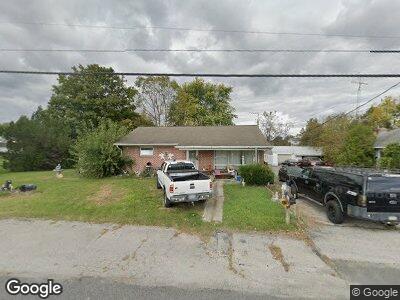
5940 Hanover Rd Hanover, PA 17331
Estimated Value: $261,000 - $283,000
3
Beds
2
Baths
1,298
Sq Ft
$207/Sq Ft
Est. Value
About This Home
This home is located at 5940 Hanover Rd, Hanover, PA 17331 and is currently estimated at $268,905, approximately $207 per square foot. 5940 Hanover Rd is a home located in Adams County with nearby schools including New Oxford Senior High School, St. Teresa of Calcutta Catholic School - McSherrystown Campus, and St. Teresa of Calcutta Catholic School - Conewago Campus.
Ownership History
Date
Name
Owned For
Owner Type
Purchase Details
Closed on
May 13, 2005
Sold by
Bashore Vincent A and Bashore Angie M
Bought by
Ripple Myrtle L
Current Estimated Value
Home Financials for this Owner
Home Financials are based on the most recent Mortgage that was taken out on this home.
Original Mortgage
$145,000
Outstanding Balance
$106,938
Interest Rate
5.95%
Mortgage Type
USDA
Estimated Equity
$165,866
Create a Home Valuation Report for This Property
The Home Valuation Report is an in-depth analysis detailing your home's value as well as a comparison with similar homes in the area
Home Values in the Area
Average Home Value in this Area
Purchase History
| Date | Buyer | Sale Price | Title Company |
|---|---|---|---|
| Ripple Myrtle L | $145,000 | -- |
Source: Public Records
Mortgage History
| Date | Status | Borrower | Loan Amount |
|---|---|---|---|
| Open | Ripple Myrtle L | $145,000 |
Source: Public Records
Tax History Compared to Growth
Tax History
| Year | Tax Paid | Tax Assessment Tax Assessment Total Assessment is a certain percentage of the fair market value that is determined by local assessors to be the total taxable value of land and additions on the property. | Land | Improvement |
|---|---|---|---|---|
| 2025 | $3,896 | $162,700 | $47,500 | $115,200 |
| 2024 | $3,599 | $162,700 | $47,500 | $115,200 |
| 2023 | $3,466 | $162,700 | $47,500 | $115,200 |
| 2022 | $3,360 | $162,700 | $47,500 | $115,200 |
| 2021 | $3,274 | $162,700 | $47,500 | $115,200 |
| 2020 | $3,278 | $162,700 | $47,500 | $115,200 |
| 2019 | $3,131 | $162,700 | $47,500 | $115,200 |
| 2018 | $3,065 | $162,700 | $47,500 | $115,200 |
| 2017 | $2,939 | $162,700 | $47,500 | $115,200 |
| 2016 | -- | $162,700 | $47,500 | $115,200 |
| 2015 | -- | $162,700 | $47,500 | $115,200 |
| 2014 | -- | $162,700 | $47,500 | $115,200 |
Source: Public Records
Map
Nearby Homes
- 11 Flint Dr
- 73 Flint Dr
- 65 Flint Dr
- 108 Flint Dr
- 54 Flint Dr Unit 50
- 24 Red Stone Ln
- 54 Red Stone Ln
- 62 Red Stone Ln Unit 43
- 9 Buckskin Dr Unit 71
- 25 Buckskin Dr Unit 73
- 17 Buckskin Dr
- 41 Squire Cir Unit 25A
- 5694 Hanover Rd
- 184 St Michaels Way
- 240 Stafford Dr Unit 96
- 25 Warm Breeze Ct Unit 97
- 355 North St
- 1004 Hostetter Rd Unit 265
- 502 South St Unit 1
- 140 N Allwood Dr Unit 327
- 5940 Hanover Rd
- 5950 Hanover Rd
- 5956 Hanover Rd Unit 2
- 28 Shoshone Dr Unit 8
- 5964 Hanover Rd
- 24 Shoshone Dr Unit 7
- 5955 Hanover Rd
- Lot at 595 Hanover Rd
- 32 Shoshone Dr Unit 9
- 36 Shoshone Dr Unit 10
- 20 Shoshone Dr Unit 6
- 105 Flint Dr
- 25 Shoshone Dr Unit 99
- 8 Shoshone Dr Unit 5
- 37 Shoshone Dr Unit 100
- 26 Seneca Dr Unit 4
- 113 Flint Dr
- 40 Shoshone Dr Unit 11
- 20 Seneca Dr Unit 3
- 15 Shoshone Dr Unit 98